> For the complete documentation index, see [llms.txt](https://docs.geopard.tech/geopard-tutorials/llms.txt). Markdown versions of documentation pages are available by appending `.md` to page URLs; this page is available as [Markdown](https://docs.geopard.tech/geopard-tutorials/tr/urun-turu-web-uygulamasi/zones-maps-and-analytics/relative-variation-factor.md).
# Bağıl değişkenlik faktörü
Farklı tarlalar ve veri kümeleri arasındaki değişkenliği karşılaştırmak için ortalamaya göre mekânsal değişkenliği nicelleştirin.
Tarlada son bir-iki hafta, bir-iki ay, hatta birkaç yıl içinde meydana gelen değişiklikleri tespit etmek, ürün gelişimi hakkında içgörü edinmeye yardımcı olur.
Göreceli Değişim Faktörü veya Göreceli Değişim İndeksi şu amaçlarla kullanılabilir:
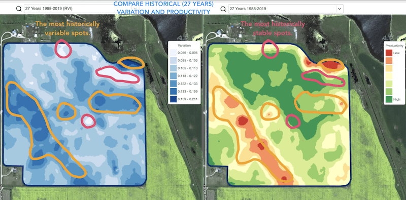
* 5-10-20 yıl boyunca benzer performans gösteren noktaları belirlemek ve hata olasılığını azaltmak için denemeleri benzer koşullara sahip alanlarda yapmak
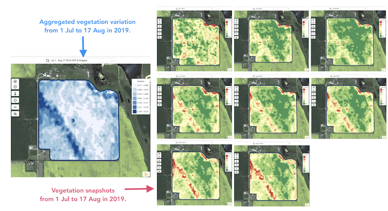
* Sezon boyunca meydana gelen değişiklikleri izlemek ve büyüme döneminde ürün performansını değerlendirmek
* Bir hava olayı, hastalık veya zararlı saldırısından sonra zarar gören alanları belirlemek ve bu alanların büyüklüğünü hesaplamak
* Son iki görüntü arasındaki farkı tespit etmek ve ürün performansını kontrol etmek.
GeoPard’ın Göreceli Değişim İndeksi (RVI), tüm bu durumları ve daha fazlasını kapsar. RVI, sezon içi ve geçmiş yönetim bölgeleriyle birlikte kullanıldığında ürün gelişimi hakkında daha fazla içgörü sağlar.
Değişiklikleri izlemek ve tarlanızdaki her nokta hakkında içgörü edinmek için tarlanızı ve uydu görüntülerini seçmeniz yeterlidir.
---
# Agent Instructions
This documentation is published with GitBook. GitBook is the documentation platform designed so that both humans and AI agents can read, navigate, and reason over technical content effectively. Learn more at gitbook.com.
## Querying This Documentation
If you need additional information that is not directly available in this page, you can query the documentation by asking a question.
Perform an HTTP GET request on the following URL with the `ask` and `goal` query parameters:
```
GET https://docs.geopard.tech/geopard-tutorials/tr/urun-turu-web-uygulamasi/zones-maps-and-analytics/relative-variation-factor.md?ask=&goal=
```
`ask` is the immediate question: it should be specific, self-contained, and written in natural language.
`goal` is what the user is ultimately trying to achieve, the reason they need the answer. Sharing it helps GitBook give you a better, more relevant answer. A goal is most helpful when it describes the outcome the user wants rather than restating the question. For example, with `ask=how do I create an API token`, a goal like `automate deployments from our CI pipeline` lets GitBook tailor the answer to that use case.
The response will contain a direct answer to the question and relevant excerpts and sources from the documentation.
Use this mechanism when the answer is not explicitly present in the current page, you need clarification or additional context, or you want to retrieve related documentation sections.