> For the complete documentation index, see [llms.txt](https://docs.geopard.tech/geopard-tutorials/llms.txt). Markdown versions of documentation pages are available by appending `.md` to page URLs; this page is available as [Markdown](https://docs.geopard.tech/geopard-tutorials/svn/predstavitev-izdelka-spletna-aplikacija/zones-maps-and-analytics/create-a-zones-map-using-satellite-imagery.md).
# Ustvari zemljevid con s pomočjo satelitskih posnetkov
Iz satelitskih posnetkov ustvarite upravljavske cone za ciljanje spremenljivosti in usmerjanje odločitev o variabilnem odmerjanju.
1. Na seznamu izberite polje in kliknite gumb **Ustvari karto območij** , izberite **Enoslojna** in nato kliknite **Naprej**.
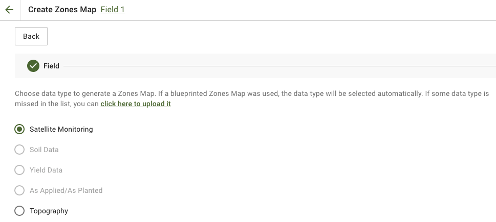
2. Izberite **Satelitsko spremljanje** vrsto podatkov za nadaljevanje.
3. V naslednjem koraku lahko izberete satelitski posnetek. Filtrirate lahko po mesecu, letu, ponudniku ali NDVI ter preklapljate med prikazi posnetka, kot sta NIR in EVI2. **Tukaj je kratek opis vrst indeksov** Povezava pojasnjuje razpoložljive indekse. Če želite spremeniti indeks, kliknite puščico ob možnosti **EVI2**. Nato kliknite **Naprej**.
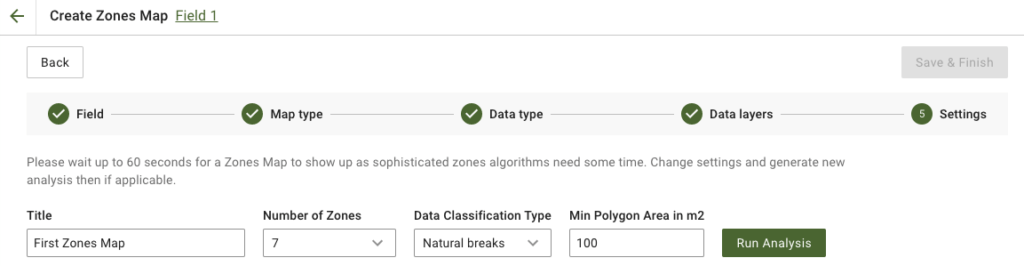
4. V naslednjem koraku lahko uredite naslov, spremenite število območij, [izberete vrsto klasifikacije podatkov](https://docs.geopard.tech/geopard-tutorials/svn/predstavitev-izdelka-spletna-aplikacija/zones-maps-and-analytics/using-data-classification.md), določite pa lahko tudi najmanjšo površino poligona v kvadratnih metrih. Kliknite **Zaženi analizo** za nadaljevanje.
Analiza lahko traja do 60 sekund, odvisno od izbranih parametrov.
5. Ko je končana, kliknite **Shrani in dokončaj**.
Ko je karta shranjena, se prikaže naslednje sporočilo:
Ustvarite lahko še eno karto območij, dodelite odmerke ali odprete pravkar ustvarjeno karto območij. Ob odprtju se prikaže podoben pogled.
---
# Agent Instructions
This documentation is published with GitBook. GitBook is the documentation platform designed so that both humans and AI agents can read, navigate, and reason over technical content effectively. Learn more at gitbook.com.
## Querying This Documentation
If you need additional information that is not directly available in this page, you can query the documentation by asking a question.
Perform an HTTP GET request on the following URL with the `ask` and `goal` query parameters:
```
GET https://docs.geopard.tech/geopard-tutorials/svn/predstavitev-izdelka-spletna-aplikacija/zones-maps-and-analytics/create-a-zones-map-using-satellite-imagery.md?ask=&goal=
```
`ask` is the immediate question: it should be specific, self-contained, and written in natural language.
`goal` is what the user is ultimately trying to achieve, the reason they need the answer. Sharing it helps GitBook give you a better, more relevant answer. A goal is most helpful when it describes the outcome the user wants rather than restating the question. For example, with `ask=how do I create an API token`, a goal like `automate deployments from our CI pipeline` lets GitBook tailor the answer to that use case.
The response will contain a direct answer to the question and relevant excerpts and sources from the documentation.
Use this mechanism when the answer is not explicitly present in the current page, you need clarification or additional context, or you want to retrieve related documentation sections.