> For the complete documentation index, see [llms.txt](https://docs.geopard.tech/geopard-tutorials/llms.txt). Markdown versions of documentation pages are available by appending `.md` to page URLs; this page is available as [Markdown](https://docs.geopard.tech/geopard-tutorials/pt-br/tour-do-produto-aplicativo-web/export-download.md).
# Exportar / Baixar
O GeoPard não prende seus dados. Você pode baixar dados brutos e análises a qualquer momento, em lote, pela interface ou pela API.
Para ver os formatos de dados de exportação compatíveis, consulte a [página Compatibilidade de dados](https://geopard.tech/data-compatibility/).
{% hint style="success" %}
Experimente exportar mapas e prescrições para suas próprias áreas: [Comece grátis](https://app.geopard.tech/auth/sign-up?utm_source=docs\&utm_medium=cta\&utm_campaign=export-download)
{% endhint %}
Raven Slingshot e Viper Pro 4 – shapefiles
Trimble – shapefiles e ISOXML
Dados John Deere GS3 e GS4 ([detalhes do GS3](https://stellarsupport.deere.com/site_media/pdf/en/manuals/gs3_2630/ompfp13946_j3_19_25oct13_402dcy.pdf), [detalhes do GS4](https://www.deere.com/assets/pdfs/common/stellarsupport/Gen4CommandCenter_ReleaseNotes_16-1_English.pdf))
John Deere – integrado ao MyJD Ops Center; veja mais detalhes em nossa publicação no blog
AGCO – ISOXML e shapefiles
CNH – compatibilidade com ISOXML/shapefiles:\
\&#xNAN;*CNH Voyager 2 ou Case Pro 700 – ISOXML*\
\&#xNAN;*Monitores Case IH – versão de firmware 30.6.0.0 ou mais recente – compatibilidade com shapefile* [detalhes](https://assets.cnhindustrial.com/caseih/NAFTA/NAFTAASSETS/Products/Advanced-Farming-Systems/Brochures/AFS%20Precision%20Farming%20Catalog_05-07-2019_PM-18308.pdf)
Topcon/TAP – compatível com shapefile
Monitores Mueller – compatíveis com ISOXML/shapefiles, [detalhes](https://www.mueller-elektronik.de/pm_manuals/TRACK-Leader%20f%C3%BCr%20Tasten-Terminals/de/701717643.html)
ISOXML (Claas, Topcon, Dickey John, CNH e outros)
Monitores AgLeader – compatibilidade com shapefile, [detalhes](https://www.agleader.com/blog/loading-prescription-files-into-ag-leader-integra-and-versa-displays/?locale=en)
 Amazone / Amatron – Shapefile, ISOXML ([detalhes do Amatron 3](https://et.amazone.de/files/pdf/MG5560-EN-II.pdf), [detalhes do Amatron4](https://et.amazone.de/files/pdf/MG6010-EN-II.pdf))
GeoJSON – formato genérico de dados vetoriais, compatível com a maioria dos programas de SIG, incluindo Esri ArcGIS e QGIS. Disponível para usuários da API.
Shapefile – formato genérico de dados vetoriais, compatível com a maioria dos programas de SIG, incluindo Esri ArcGIS e QGIS.
API / widgets para integrar as análises do GeoPard a outros sistemas.
### **Exportação de limites de talhões**
Para exportar um shapefile do seu talhão ou dos seus talhões, use **Exportar dados** e acesse a guia **Baixar arquivos** .
1. Expanda a fazenda e o talhão desejados. Selecione na árvore o limite que deseja exportar e clique em **Baixar** ou **Baixar selecionados** se quiser exportar várias camadas selecionadas de uma só vez.
O limite selecionado será baixado no seu computador como um arquivo .shp dentro de um arquivo .zip, que você poderá carregar no maquinário.
### **Exportação de mapas de zonas**
O GeoPard permite exportar mapas de zonas dos seus talhões com aplicações em taxa variável para fluxos de trabalho de agricultura de precisão.
Clique no item de menu **Exportar dados** . Em seguida, acesse a guia **Baixar arquivos** .
1. Expanda a fazenda e o talhão desejados. Selecione na árvore os mapas de zonas que deseja exportar e clique em **Baixar** ou **Baixar seleção** se quiser exportar vários mapas selecionados de uma só vez.
Os mapas de zonas selecionados serão baixados para o seu computador como um arquivo .shp dentro de um arquivo .zip, que você poderá carregar no maquinário.
### Exportar ensaios na fazenda
Os ensaios são exportados a partir do respectivo **Mapa de zonas**.
O GeoPard exporta o ensaio junto com o Mapa de zonas como uma única camada pronta para aplicação. Isso mantém os tratamentos georreferenciados e prontos para a execução pela máquina ou para análises posteriores.
Siga este fluxo de trabalho:
1. Abra o talhão e acesse o **Mapa de zonas** que contém o ensaio salvo.
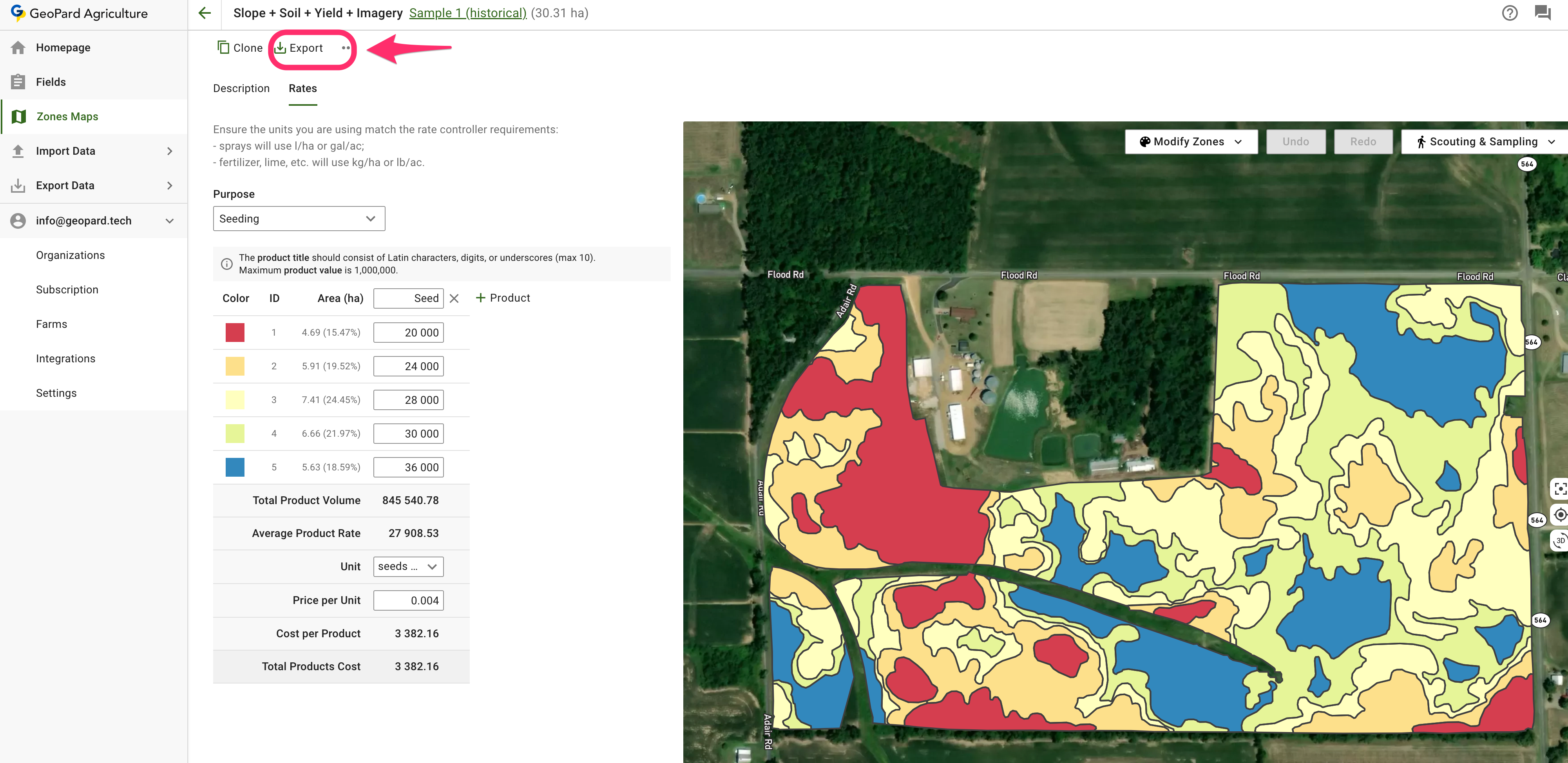
2. Clique em **Exportar** na página do Mapa de zonas.
3. Escolha o formato de saída necessário:
* **ISOXML** para terminais e controladores compatíveis
* **Exportação para John Deere** quando quiser enviar a prescrição para o Operations Center
* **Shapefile** quando precisar de um arquivo vetorial compatível com SIG ou pronto para controladores
4. Baixe o arquivo exportado e carregue-o no fluxo de trabalho do seu equipamento.
{% hint style="info" %}
Os ensaios não são exportados como uma camada independente. Eles são exportados junto com o Mapa de zonas correspondente.
{% endhint %}
Páginas relacionadas úteis:
* [Projeto e criação de ensaios na fazenda](https://docs.geopard.tech/geopard-tutorials/pt-br/tour-do-produto-aplicativo-web/on-farm-trials-design-and-creation.md)
* [Exportar mapa VRA no formato ISOXML](https://docs.geopard.tech/geopard-tutorials/pt-br/tour-do-produto-aplicativo-web/export-download/export-vra-map-in-isoxml-format.md)
* [Exportar mapas Rx para o John Deere Operations Center como arquivos](https://docs.geopard.tech/geopard-tutorials/pt-br/tour-do-produto-aplicativo-web/john-deere-operations-center-integration/6.-export-rx-maps-to-john-deere-operations-center-as-files.md)
* [Exportar mapas Rx para o John Deere Operations Center como planos de trabalho](https://docs.geopard.tech/geopard-tutorials/pt-br/tour-do-produto-aplicativo-web/john-deere-operations-center-integration/8.-export-rx-maps-to-john-deere-operations-center-as-work-plans.md)
### Exportar mapa VRA no formato ISOXML
O GeoPard oferece suporte à exportação nos formatos de dados ISOBUS / ISOXML ([ISO 11783-1:2017](https://www.iso.org/standard/57556.html)) .
Etapas para exportar:
1. Clique em "Ir para a página do mapa de zonas"
2. Clique em "Exportar"
3. Baixar ISOXML
4. O arquivo baixado `.zip` deve ser parecido com este. Ele contém as três variantes de ISOXML. Consulte as especificações do seu monitor para escolher a opção correta.
O arquivo ZIP de exportação ISOXML resultante é parecido com este
### **Exportar para o MyJohnDeere**
Os usuários do GeoPard podem exportar dados, como prescrições Rx e outras camadas de mapas, para o John Deere Operations Center.
Você pode exportar os conjuntos de dados pelo item de menu **Exportar dados** Selecione **Para o MyJohnDeere**.
1. Você deve selecionar uma organização de destino que a GeoPard usará para carregar os arquivos. Se a organização correta não estiver disponível, acesse **Aqui, você pode alterar o link da organização** e adicioná-la. Se a organização do John Deere estiver desativada (o nome aparece em cinza), conceda acesso no John Deere Operations Center. Clique em **Avançar**.
2. Você deve selecionar os ativos que a GeoPard carregará no John Deere Operations Center. É possível filtrar os ativos. Depois de selecionar todos os ativos, você pode carregá-los todos clicando no botão **Exportar tudo** ou carregar ativos individualmente clicando no botão **Exportar** button.
Após clicar, você verá uma mensagem com o resultado da operação. Em seguida, confira o resultado no John Deere Operations Center.
### **Exportar equações**
Agora é possível baixar o Mapa de equações com os dados agrupados em MultiPolygons por valor.\
O Mapa de equações com poucas taxas é exportado assim:
Assim, a máquina não precisa alternar entre zonas com tanta frequência.\
\
Você pode baixar esses arquivos usando:\
\
\
Observação: ainda não modificamos o fluxo "Exportar para My JohnDeere como arquivos" para oferecer suporte a esse recurso.
---
# Agent Instructions
This documentation is published with GitBook. GitBook is the documentation platform designed so that both humans and AI agents can read, navigate, and reason over technical content effectively. Learn more at gitbook.com.
## Querying This Documentation
If you need additional information that is not directly available in this page, you can query the documentation by asking a question.
Perform an HTTP GET request on the following URL with the `ask` and `goal` query parameters:
```
GET https://docs.geopard.tech/geopard-tutorials/pt-br/tour-do-produto-aplicativo-web/export-download.md?ask=&goal=
```
`ask` is the immediate question: it should be specific, self-contained, and written in natural language.
`goal` is what the user is ultimately trying to achieve, the reason they need the answer. Sharing it helps GitBook give you a better, more relevant answer. A goal is most helpful when it describes the outcome the user wants rather than restating the question. For example, with `ask=how do I create an API token`, a goal like `automate deployments from our CI pipeline` lets GitBook tailor the answer to that use case.
The response will contain a direct answer to the question and relevant excerpts and sources from the documentation.
Use this mechanism when the answer is not explicitly present in the current page, you need clarification or additional context, or you want to retrieve related documentation sections.