> For the complete documentation index, see [llms.txt](https://docs.geopard.tech/geopard-tutorials/llms.txt). Markdown versions of documentation pages are available by appending `.md` to page URLs; this page is available as [Markdown](https://docs.geopard.tech/geopard-tutorials/pl/przewodnik-po-produkcie-aplikacja-webowa/zones-maps-and-analytics.md).

# Mapy stref i analityka

Twórz strefy zarządzania na podstawie obrazów, plonów, gleby, topografii i równań, aby podejmować lepsze decyzje o zmiennym dawkowaniu.

Użytkownicy mogą rozpocząć tworzenie mapy stref na dwa sposoby. Pierwszy polega na kliknięciu przycisku **Utwórz mapę stref** , który pozwala wybrać sposób utworzenia mapy stref. Drugi sposób to **Klonowanie** istniejącej mapy stref, aby przetestować parametry i modyfikacje bez konieczności zmiany wyboru metody tworzenia mapy stref.

{% hint style="info" %}
Zobacz interaktywną stronę poświęconą strefom zarządzania i mapom VRA w serwisie geopard.tech: [Strefy zarządzania i mapy VRA](https://geopard.tech/management-zones-vra-maps/)
{% endhint %}

## Wyświetl mapę stref

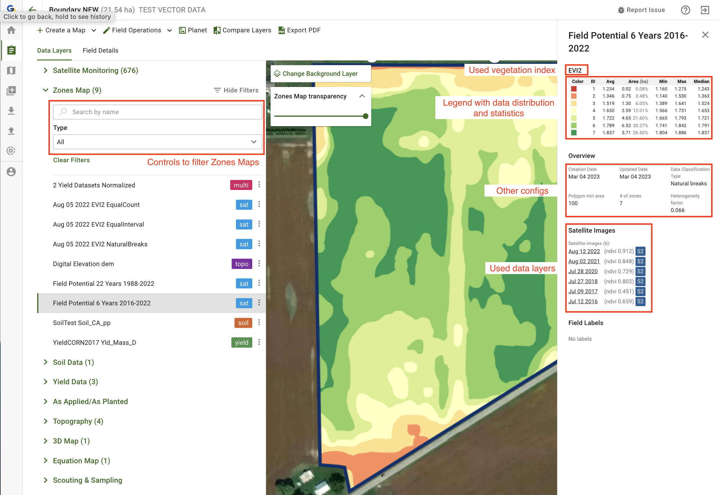
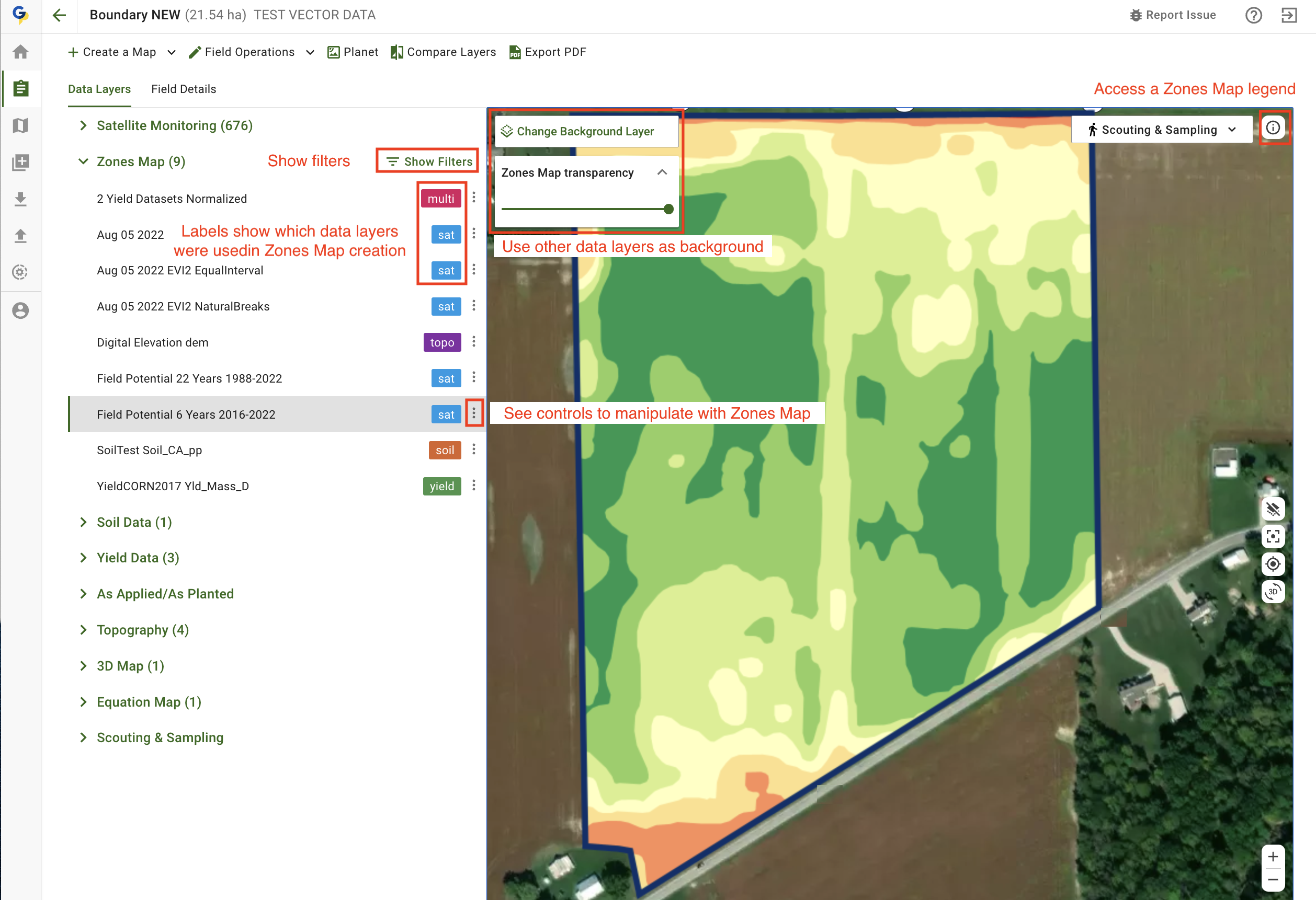
Na kolejnych ekranach znajdziesz krótkie omówienie dostępnych elementów sterujących, które pomoże Ci zrozumieć, jakie informacje znajdują się w poszczególnych częściach ekranu.

<figure><img src="https://3832317038-files.gitbook.io/~/files/v0/b/gitbook-x-prod.appspot.com/o/spaces%2FYICBELdyAXXebKAzfLOR%2Fuploads%2Fxq40oN6Fp3OTLVB3vxAn%2Fimage.png?alt=media&amp;token=05cbc074-02d2-4219-bdc4-0554998436d9" alt=""><figcaption><p>Elementy sterujące mapami stref</p></figcaption></figure>

<figure><img src="https://3832317038-files.gitbook.io/~/files/v0/b/gitbook-x-prod.appspot.com/o/spaces%2FYICBELdyAXXebKAzfLOR%2Fuploads%2F6qMbc4RgZYE5WC4KKuAJ%2Fimage.png?alt=media&amp;token=e2bda194-60c7-4e34-baa2-434bc94b3ee9" alt=""><figcaption><p>Elementy sterujące mapami stref</p></figcaption></figure>

## Użyj przycisku „Utwórz mapę stref”

Aby utworzyć mapę stref dla pola, otwórz je z listy pól, a następnie kliknij przycisk **Utwórz mapę stref** :

<figure><img src="https://lh5.googleusercontent.com/7IapbLUHoeZR3k-q_yNsfktTcTTbd7sJbLdflCuRCauAHm88Ckro45eeRObbCDU2SvcOj3yzBpRRUHdqYaME8cYYAodwpLQVohl3HloDgzdG4VhIEdD9f6M9gdV4uh2Ogj9ioGG1" alt="This image has an empty alt attribute; its file name is 24-1.png" width="563"><figcaption><p>Rozpocznij tworzenie mapy stref</p></figcaption></figure>

Przejdziesz do narzędzia tworzenia stref, w którym należy wybrać typ mapy stref, którą chcesz utworzyć.

<figure><img src="https://lh6.googleusercontent.com/M5yZVRKrPxTeEzqGoNxeTo_pIY8lZhPmRK_CfkaarMSTtUzaTmih2fE_JCN8Xazjj3KeSTeJ7LatqzbInUtWDydLFnyL3Lv4dF65TGC0AS-ivaAleEszHnz8-CjotlhMZAJl4fz9" alt="This image has an empty alt attribute; its file name is image-1.png" width="563"><figcaption><p>Dostępne typy map stref</p></figcaption></figure>

Więcej informacji o korzystaniu z poszczególnych typów znajdziesz w kolejnych sekcjach:

1. [Tworzenie mapy stref na podstawie zdjęć satelitarnych](https://docs.geopard.tech/geopard-tutorials/pl/przewodnik-po-produkcie-aplikacja-webowa/zones-maps-and-analytics/create-a-zones-map-using-satellite-imagery.md)
2. [Tworzenie mapy stref na podstawie danych o glebie, plonach lub zabiegach aplikacyjnych](https://docs.geopard.tech/geopard-tutorials/pl/przewodnik-po-produkcie-aplikacja-webowa/zones-maps-and-analytics/create-a-zones-map-using-soil-yield-or-as-applied-data.md)
3. [Tworzenie mapy stref na podstawie ukształtowania terenu](https://docs.geopard.tech/geopard-tutorials/pl/przewodnik-po-produkcie-aplikacja-webowa/zones-maps-and-analytics/create-a-zones-map-using-topography.md)
4. [Tworzenie mapy stref na podstawie szablonu](https://docs.geopard.tech/geopard-tutorials/pl/przewodnik-po-produkcie-aplikacja-webowa/zones-maps-and-analytics/create-a-zones-map-using-a-template.md)
5. [Korzystanie z klasyfikacji danych](https://docs.geopard.tech/geopard-tutorials/pl/przewodnik-po-produkcie-aplikacja-webowa/zones-maps-and-analytics/using-data-classification.md)
6. [Jak przypisywać VRA](https://docs.geopard.tech/geopard-tutorials/pl/przewodnik-po-produkcie-aplikacja-webowa/zones-maps-and-analytics/assign-variable-rates-in-zones-ag-input-rates-distribution-tool.md)
7. [Edycja mapy stref: łączenie i dzielenie stref](https://docs.geopard.tech/geopard-tutorials/pl/przewodnik-po-produkcie-aplikacja-webowa/zones-maps-and-analytics/edit-zones-map-merge-and-split.md)
8. [Strefy wieloletnie](https://docs.geopard.tech/geopard-tutorials/pl/przewodnik-po-produkcie-aplikacja-webowa/zones-maps-and-analytics/multi-year-zones.md)
9. [Analiza wielu warstw](https://docs.geopard.tech/geopard-tutorials/pl/przewodnik-po-produkcie-aplikacja-webowa/zones-maps-and-analytics/multi-layer-analytics.md)

## Klonowanie istniejącej mapy stref

Aby sklonować istniejącą mapę stref, kliknij przycisk <img src="https://3832317038-files.gitbook.io/~/files/v0/b/gitbook-x-prod.appspot.com/o/spaces%2FYICBELdyAXXebKAzfLOR%2Fuploads%2F3vG8QyQkqzewbqEGatt6%2Fimage.png?alt=media&amp;token=740d067b-4388-47b8-b28f-b308efc70c00" alt="" data-size="line"> i wybierz opcję **Klonuj** . Zostanie otwarty kreator map stref z wczytaną wcześniej używaną konfiguracją, obejmującą między innymi warstwy danych, liczbę stref i inne ustawienia.
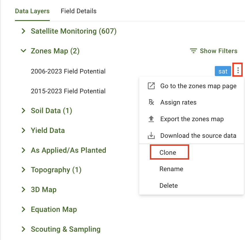
<figure><img src="https://3832317038-files.gitbook.io/~/files/v0/b/gitbook-x-prod.appspot.com/o/spaces%2FYICBELdyAXXebKAzfLOR%2Fuploads%2FLZZvkkL1VF7uAFBMBbuR%2Fimage.png?alt=media&amp;token=cf13456d-7817-4ce8-b861-c7d08286e983" alt="" width="563"><figcaption><p>Rozpocznij klonowanie istniejącej mapy stref</p></figcaption></figure>


---

# Agent Instructions
This documentation is published with GitBook. GitBook is the documentation platform designed so that both humans and AI agents can read, navigate, and reason over technical content effectively. Learn more at gitbook.com.

## Querying This Documentation
If you need additional information that is not directly available in this page, you can query the documentation by asking a question.

Perform an HTTP GET request on the following URL with the `ask` and `goal` query parameters:

```
GET https://docs.geopard.tech/geopard-tutorials/pl/przewodnik-po-produkcie-aplikacja-webowa/zones-maps-and-analytics.md?ask=<question>&goal=<user_goal>
```

`ask` is the immediate question: it should be specific, self-contained, and written in natural language.
`goal` is what the user is ultimately trying to achieve, the reason they need the answer. Sharing it helps GitBook give you a better, more relevant answer. A goal is most helpful when it describes the outcome the user wants rather than restating the question. For example, with `ask=how do I create an API token`, a goal like `automate deployments from our CI pipeline` lets GitBook tailor the answer to that use case.

The response will contain a direct answer to the question and relevant excerpts and sources from the documentation.

Use this mechanism when the answer is not explicitly present in the current page, you need clarification or additional context, or you want to retrieve related documentation sections.