> For the complete documentation index, see [llms.txt](https://docs.geopard.tech/geopard-tutorials/llms.txt). Markdown versions of documentation pages are available by appending `.md` to page URLs; this page is available as [Markdown](https://docs.geopard.tech/geopard-tutorials/pl/dokumentacja-api/schematy-podstawowych-przeplywow/3.-pobierz-obrazy-satelitarne.md).
# 3. Pobierz obrazy satelitarne
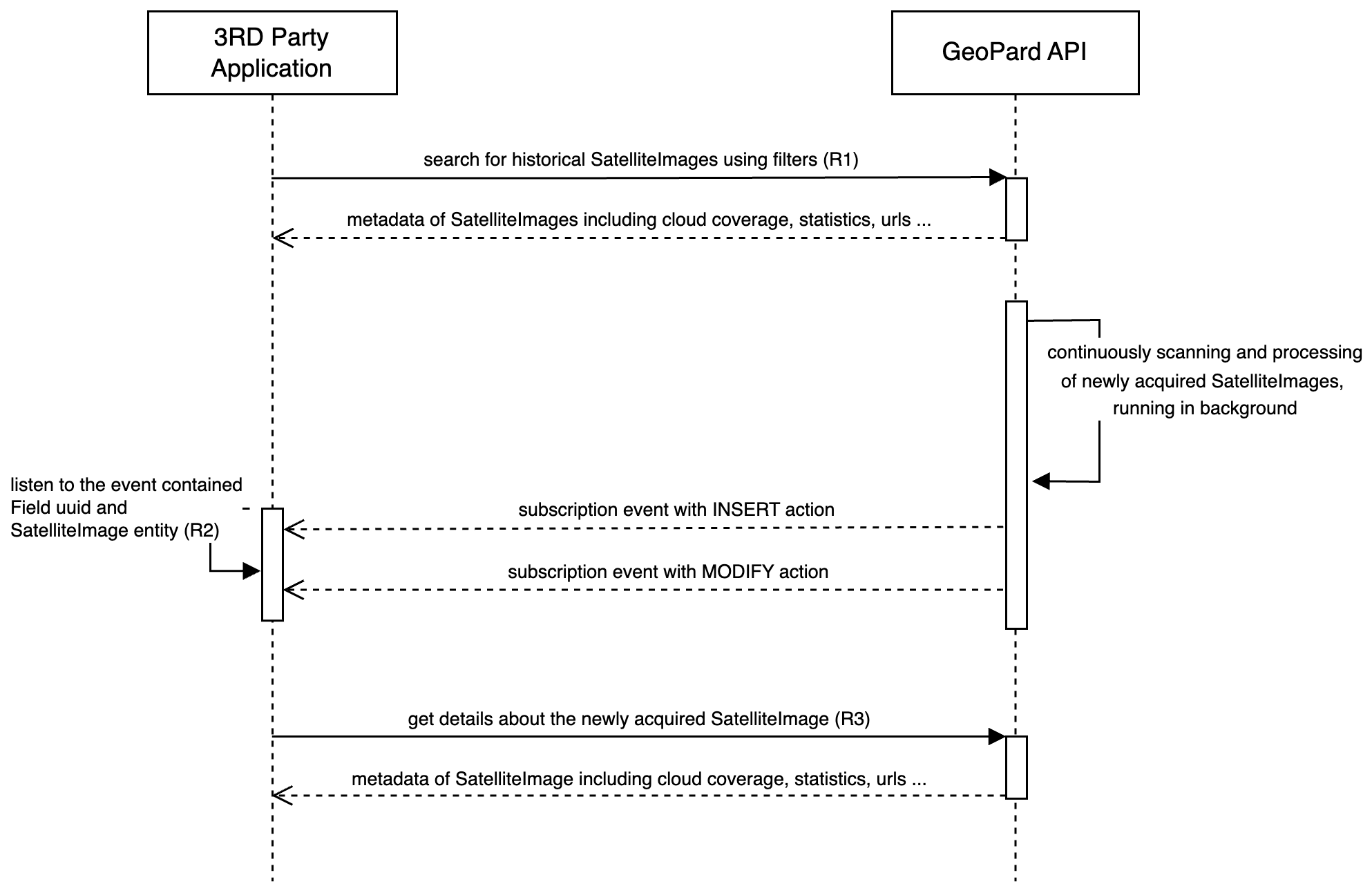
Poniższy diagram pokazuje, jak pobrać historyczne obrazy satelitarne i otrzymywać nowo pozyskane, gdy tylko staną się dostępne w GeoPard.
GeoPard obsługuje kilku dostawców, w tym Sentinel-2, Landsat 4/5/7/8/9 oraz Planet. Obrazy satelitarne można pobierać za pomocą ogólnych zapytań, takich jak `getFarms` jak i `getFields`, przy czym odpowiednie dane znajdują się w encji Field ([Żądanie 1 lub R1](/geopard-tutorials/pl/dokumentacja-api/przeglad-zapytan-api-geopard/3.-zapytanie-pobierz-satelliteimages.md)). Odbiorcy API mogą filtrować obrazy satelitarne według zakresu dat, dostawcy, procentu zachmurzenia oraz renderowanych typów map geo.
Aby być na bieżąco z nowo pozyskanymi i przetworzonymi obrazami satelitarnymi, API GeoPard wysyła zdarzenia subskrypcji przez WebSocket ([Żądanie 2 lub R2](/geopard-tutorials/pl/dokumentacja-api/przeglad-zapytan-api-geopard/1.-subskrypcja-pobierz-zdarzenia.md)). Gdy otrzymasz `MODIFY` zdarzenie dla obrazu satelitarnego dotyczącego odpowiedniego pola, ten obraz jest gotowy do pobrania z API GeoPard po jego UUID ([Żądanie 3 lub R3](/geopard-tutorials/pl/dokumentacja-api/przeglad-zapytan-api-geopard/4.-zapytanie-pobierz-zdefiniowany-satelliteimage.md)).
Taka architektura oparta na zdarzeniach zapewnia, że klienci API są szybko powiadamiani i mogą uzyskać dostęp do najnowszego obrazu satelitarnego natychmiast po jego przetworzeniu i udostępnieniu.
Diagram sekwencji: pobieranie historycznych i nowo pozyskanych obrazów satelitarnych
---
# Agent Instructions
This documentation is published with GitBook. GitBook is the documentation platform designed so that both humans and AI agents can read, navigate, and reason over technical content effectively. Learn more at gitbook.com.
## Querying This Documentation
If you need additional information that is not directly available in this page, you can query the documentation by asking a question.
Perform an HTTP GET request on the following URL with the `ask` and `goal` query parameters:
```
GET https://docs.geopard.tech/geopard-tutorials/pl/dokumentacja-api/schematy-podstawowych-przeplywow/3.-pobierz-obrazy-satelitarne.md?ask=&goal=
```
`ask` is the immediate question: it should be specific, self-contained, and written in natural language.
`goal` is what the user is ultimately trying to achieve, the reason they need the answer. Sharing it helps GitBook give you a better, more relevant answer. A goal is most helpful when it describes the outcome the user wants rather than restating the question. For example, with `ask=how do I create an API token`, a goal like `automate deployments from our CI pipeline` lets GitBook tailor the answer to that use case.
The response will contain a direct answer to the question and relevant excerpts and sources from the documentation.
Use this mechanism when the answer is not explicitly present in the current page, you need clarification or additional context, or you want to retrieve related documentation sections.