# Flerårssoner
Historiske (flerårige) styringssoner gir innsikt i hvert punkt på jordet.
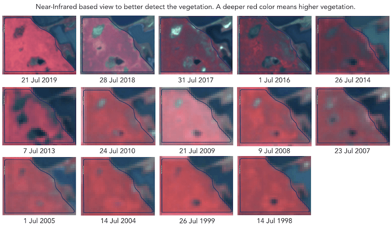
Historiske (flerårige) styringssoner bygges basert på over 30 år med arkiv av satellittbilder. Bilder med topp vegetasjon i hver sesong velges automatisk som inndata til analyser. Ellers representerer hvert slikt bilde en potensiell avlingsfil for det aktuelle året.
Mønsteret i avlingsutviklingen på jordet hjelper deg å bli bedre kjent med jordbruksarealet og å ta riktige beslutninger med riktige mengder innsatsmidler på riktig sted. Historiske styringssoner kan brukes som en mal for tildelingsfiler (Rx-filer) til såing, gjødsling og sonebasert jordprøvetaking.
---
# Agent Instructions: Querying This Documentation
If you need additional information that is not directly available in this page, you can query the documentation dynamically by asking a question.
Perform an HTTP GET request on the current page URL with the `ask` query parameter:
```
GET https://docs.geopard.tech/geopard-tutorials/nor/produkttur-nettapp/soner-kart-og-analyse/flerarssoner.md?ask=
```
The question should be specific, self-contained, and written in natural language.
The response will contain a direct answer to the question and relevant excerpts and sources from the documentation.
Use this mechanism when the answer is not explicitly present in the current page, you need clarification or additional context, or you want to retrieve related documentation sections.