> For the complete documentation index, see [llms.txt](https://docs.geopard.tech/geopard-tutorials/llms.txt). Markdown versions of documentation pages are available by appending `.md` to page URLs; this page is available as [Markdown](https://docs.geopard.tech/geopard-tutorials/lva/produkta-apskats-timekla-lietotne/export-download.md).
# Eksportēt / lejupielādēt
GeoPard nenotur jūsu datus ieslodzītus. Jūs jebkurā laikā varat lejupielādēt neapstrādātus datus un analītiku masveidā, izmantojot lietotāja saskarni vai API.
Informāciju par atbalstītajiem eksportējamo datu formātiem skatiet [lapā “Datu saderība”](https://geopard.tech/data-compatibility/).
{% hint style="success" %}
Izmēģiniet karšu un mēslojuma vai sējas normu karšu eksportēšanu saviem laukiem: [Sākt bez maksas](https://app.geopard.tech/auth/sign-up?utm_source=docs\&utm_medium=cta\&utm_campaign=export-download)
{% endhint %}
Raven Slingshot un Viper Pro 4 — shapefile faili
Trimble — shapefile faili un ISOXML
John Deere GS3 un GS4 dati ([informācija par GS3](https://stellarsupport.deere.com/site_media/pdf/en/manuals/gs3_2630/ompfp13946_j3_19_25oct13_402dcy.pdf), [informācija par GS4](https://www.deere.com/assets/pdfs/common/stellarsupport/Gen4CommandCenter_ReleaseNotes_16-1_English.pdf))
John Deere — integrēts ar MyJD Ops Center; skatiet informāciju mūsu emuāra ierakstā
AGCO — ISOXML un shapefile faili
CNH — tiek atbalstīti ISOXML un shapefile formāti:\
\&#xNAN;*CNH Voyager 2 vai Case Pro 700 — ISOXML*\
\&#xNAN;*Case IH monitori — programmaparatūras versija 30.6.0.0 vai jaunāka — saderība ar shapefile formātu* [informācija](https://assets.cnhindustrial.com/caseih/NAFTA/NAFTAASSETS/Products/Advanced-Farming-Systems/Brochures/AFS%20Precision%20Farming%20Catalog_05-07-2019_PM-18308.pdf)
Topcon/TAP — tiek atbalstīts shapefile formāts
Mueller monitori — tiek atbalstīti ISOXML un shapefile formāti, [informācija](https://www.mueller-elektronik.de/pm_manuals/TRACK-Leader%20f%C3%BCr%20Tasten-Terminals/de/701717643.html)
ISOXML (Claas, Topcon, Dickey John, CNH un citi)
AgLeader monitori — tiek atbalstīts shapefile formāts, [informācija](https://www.agleader.com/blog/loading-prescription-files-into-ag-leader-integra-and-versa-displays/?locale=en)
 Amazone / Amatron — shapefile un ISOXML formāti ([informācija par Amatron 3](https://et.amazone.de/files/pdf/MG5560-EN-II.pdf), [informācija par Amatron4](https://et.amazone.de/files/pdf/MG6010-EN-II.pdf))
GeoJSON — vispārīgs vektordatu formāts. To atbalsta lielākā daļa ĢIS programmu, tostarp Esri ArcGIS un QGIS. Pieejams API lietotājiem.
Shapefile — vispārīgs vektordatu formāts. To atbalsta lielākā daļa ĢIS programmu, tostarp Esri ArcGIS un QGIS.
API / logrīki GeoPard analītikas integrēšanai citās sistēmās.
### **Lauku robežu eksportēšana**
Lai eksportētu shapefile failu ar viena vai vairāku lauku robežām, izmantojiet **Datu eksportēšana** un atveriet cilni **Failu lejupielāde** .
1. Izvērsiet vajadzīgo saimniecību un lauku. Koka skatā atlasiet eksportējamo robežu un pēc tam noklikšķiniet uz **Lejupielādēt** vai **Lejupielādēt atlasīto** ja vēlaties vienlaikus eksportēt vairākus atlasītos slāņus.
Atlasītā robeža tiks lejupielādēta datorā kā .shp fails .zip arhīvā. Pēc tam to varēsiet augšupielādēt tehnikā.
### **Zonu karšu eksportēšana**
GeoPard ļauj eksportēt zonu kartes no jūsu laukiem, lai precīzās lauksaimniecības darba procesos izmantotu mainīgas devas lietojumus.
Noklikšķiniet uz izvēlnes vienuma **Datu eksportēšana** Pēc tam atveriet cilni **Failu lejupielāde** .
1. Izvērsiet vajadzīgo saimniecību un lauku. Koka skatā atlasiet eksportējamās zonu kartes un pēc tam noklikšķiniet uz **Lejupielādēt** vai **Lejupielādēt atlasītos** ja vēlaties vienlaikus eksportēt vairākas atlasītās kartes.
Atlasīto zonu kartes tiks lejupielādētas jūsu datorā kā .shp fails .zip arhīvā, ko varat augšupielādēt tehnikā.
### Eksportēt saimniecības izmēģinājumus
Izmēģinājumi tiek eksportēti no saistītās **Zonu kartes**.
GeoPard eksportē izmēģinājumu kopā ar Zonu karti kā vienu darbam ar tehniku gatavu slāni. Tādējādi apstrādes varianti tiek piesaistīti koordinātām un ir gatavi izpildei ar tehniku vai vēlākai analīzei.
Veiciet tālāk norādītās darbības:
1. Atveriet lauku un dodieties uz **Zonu karti** kurā ir saglabāts izmēģinājums.
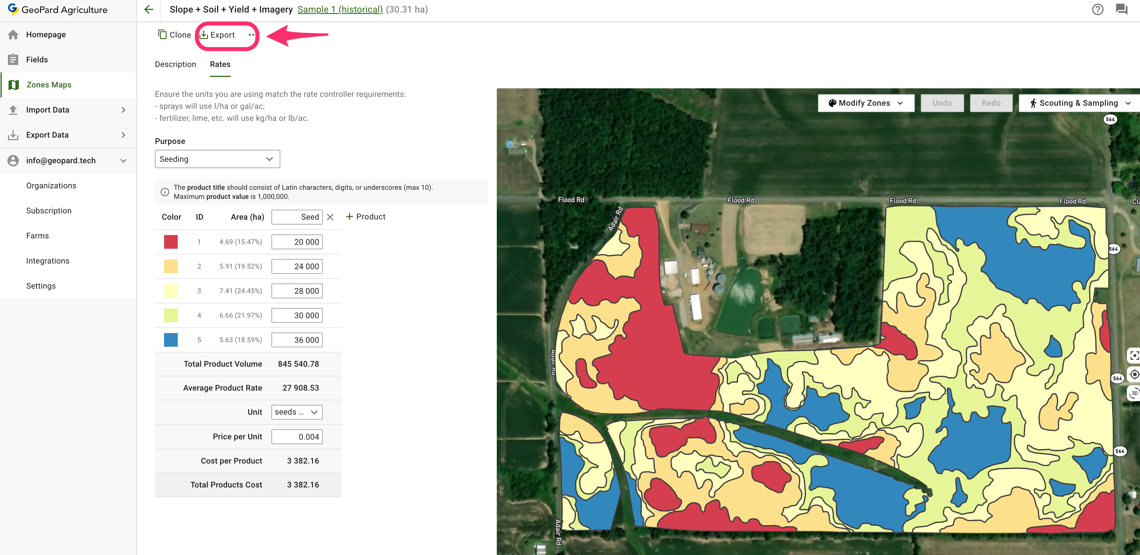
2. Noklikšķiniet uz **Eksportēt** Zonu kartes lapā.
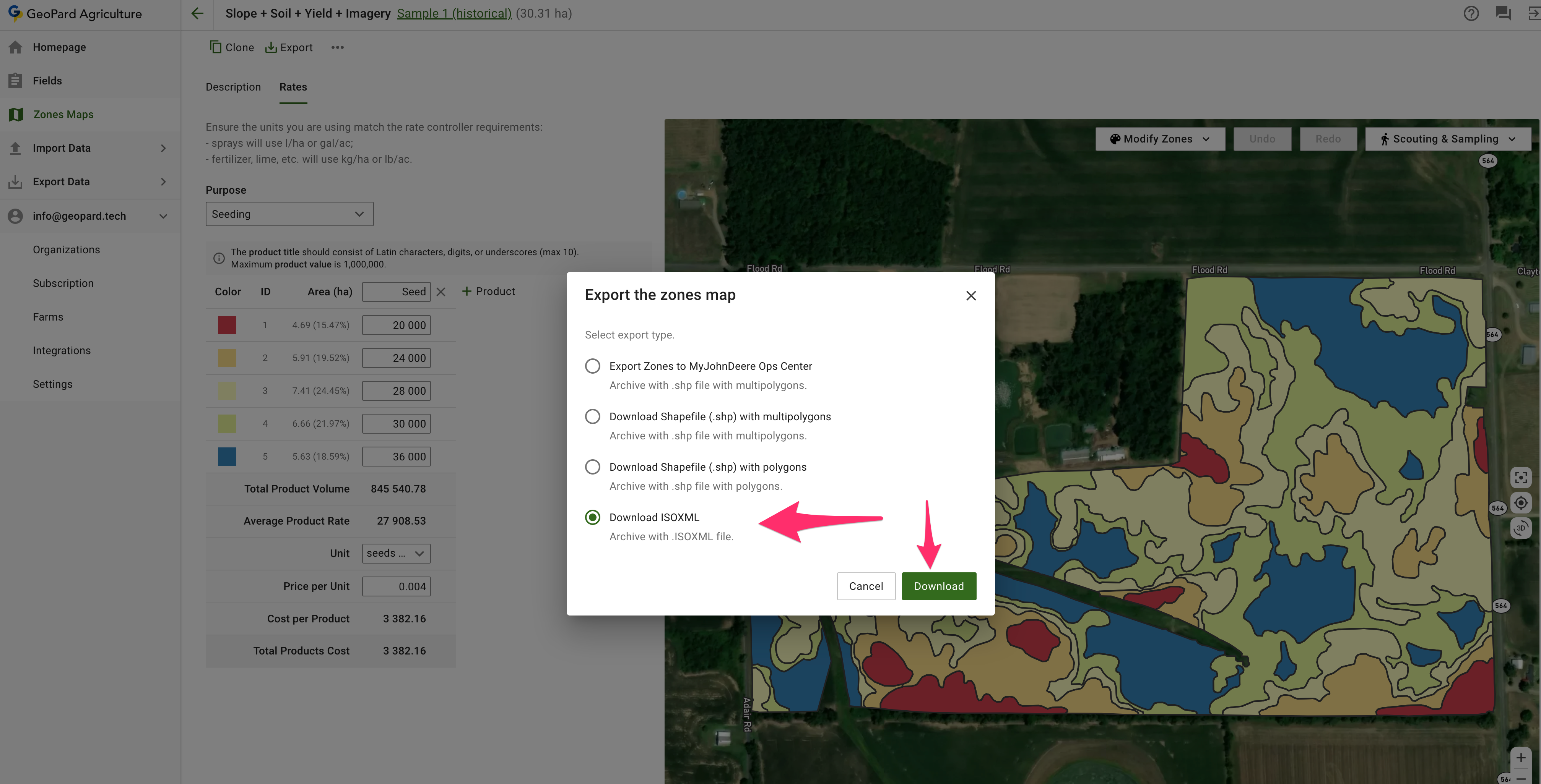
3. Izvēlieties vajadzīgo izvades formātu:
* **ISOXML** saderīgiem termināļiem un kontrolleriem
* **John Deere eksports** ja vēlaties nosūtīt izkliedes karti uz Operations Center
* **Shapefile** ja nepieciešams GIS vai darbam ar kontrolleri gatavs vektorfails
4. Lejupielādējiet eksportēto failu un ielādējiet to tehnikas darbplūsmā.
{% hint style="info" %}
Izmēģinājumi netiek eksportēti kā atsevišķs, patstāvīgs slānis. Tie tiek eksportēti apvienojumā ar saistīto Zonu karti.
{% endhint %}
Noderīgas saistītās lapas:
* [Saimniecības izmēģinājumu plānošana un izveide](https://docs.geopard.tech/geopard-tutorials/lva/produkta-apskats-timekla-lietotne/on-farm-trials-design-and-creation.md)
* [Eksportēt mainīgas devas karti ISOXML formātā](https://docs.geopard.tech/geopard-tutorials/lva/produkta-apskats-timekla-lietotne/export-download/export-vra-map-in-isoxml-format.md)
* [Eksportēt Rx kartes uz John Deere Operations Center kā failus](https://docs.geopard.tech/geopard-tutorials/lva/produkta-apskats-timekla-lietotne/john-deere-operations-center-integration/6.-export-rx-maps-to-john-deere-operations-center-as-files.md)
* [Eksportēt Rx kartes uz John Deere Operations Center kā darba plānus](https://docs.geopard.tech/geopard-tutorials/lva/produkta-apskats-timekla-lietotne/john-deere-operations-center-integration/8.-export-rx-maps-to-john-deere-operations-center-as-work-plans.md)
### Eksportēt mainīgas devas karti ISOXML formātā
GeoPard atbalsta eksportēšanu ISOBUS / ISOXML ([ISO 11783-1:2017](https://www.iso.org/standard/57556.html)) datu formātos.
Eksportēšanas darbības:
1. Noklikšķiniet uz “Go to the Zones map page”
2. Noklikšķiniet uz “Export”
3. Lejupielādēt ISOXML
4. Lejupielādētajam `.zip` failam jāizskatās šādi. Tajā ir visi trīs ISOXML varianti. Apskatiet termināļa specifikāciju, lai izvēlētos pareizo variantu.
Izveidotajam ISOXML eksportēšanas ZIP failam jāizskatās šādi
### **Eksportēt uz MyJohnDeere**
GeoPard lietotāji var eksportēt datus, piemēram, Rx izkliedes kartes un citus karšu slāņus, uz John Deere Operations Center.
Datu kopas var eksportēt, izmantojot izvēlnes vienumu **Eksportēt datus** . Atlasiet **Uz MyJohnDeere**.
1. Atlasiet mērķa organizāciju, ko GeoPard izmantos failu augšupielādei. Ja vajadzīgā organizācija nav pieejama, atveriet **Šeit varat mainīt organizācijas** saiti un pievienot organizācijas. Ja John Deere organizācija ir atspējota (tās nosaukums ir pelēkā krāsā), piešķiriet piekļuvi John Deere Operations Center. Noklikšķiniet uz **Tālāk**.
2. Atlasiet resursus, ko GeoPard augšupielādēs John Deere Operations Center. Resursus var filtrēt. Kad visi resursi ir atlasīti, varat augšupielādēt tos visus, noklikšķinot uz pogas **Eksportēt visu** vai augšupielādēt atsevišķus resursus, noklikšķinot uz pogas **Eksportēt** .
Pēc noklikšķināšanas tiks parādīts ziņojums par darbības rezultātu. Pēc tam rezultātu varēsiet skatīt John Deere Operations Center.
### **Eksporta vienādojumi**
Tagad vienādojumu karti var lejupielādēt, apvienojot datus multipoligonos pēc to vērtības.\
Vienādojuma karte ar dažām devām tiek eksportēta šādi:
Tādējādi tehnikai nav pārāk bieži jāpārslēdzas starp zonām.\
\
Šādus arhīvus var lejupielādēt, izmantojot:\
\
\
Ņemiet vērā: mēs vēl neesam mainījuši darbplūsmu “Export to My JohnDeere as Files”, lai atbalstītu šo funkciju.
---
# Agent Instructions
This documentation is published with GitBook. GitBook is the documentation platform designed so that both humans and AI agents can read, navigate, and reason over technical content effectively. Learn more at gitbook.com.
## Querying This Documentation
If you need additional information that is not directly available in this page, you can query the documentation by asking a question.
Perform an HTTP GET request on the following URL with the `ask` and `goal` query parameters:
```
GET https://docs.geopard.tech/geopard-tutorials/lva/produkta-apskats-timekla-lietotne/export-download.md?ask=&goal=
```
`ask` is the immediate question: it should be specific, self-contained, and written in natural language.
`goal` is what the user is ultimately trying to achieve, the reason they need the answer. Sharing it helps GitBook give you a better, more relevant answer. A goal is most helpful when it describes the outcome the user wants rather than restating the question. For example, with `ask=how do I create an API token`, a goal like `automate deployments from our CI pipeline` lets GitBook tailor the answer to that use case.
The response will contain a direct answer to the question and relevant excerpts and sources from the documentation.
Use this mechanism when the answer is not explicitly present in the current page, you need clarification or additional context, or you want to retrieve related documentation sections.