> For the complete documentation index, see [llms.txt](https://docs.geopard.tech/geopard-tutorials/llms.txt). Markdown versions of documentation pages are available by appending `.md` to page URLs; this page is available as [Markdown](https://docs.geopard.tech/geopard-tutorials/jpn/tsu-webapuri/znmapputo/dtawotteznmappuwo.md).
# 土壌、収量、散布実績データを使ってゾーンマップを作成
土壌、収量、機械データから管理ゾーンを作成し、圃場の真のばらつきを反映させます。
データセットからゾーンマップを作成したい場合は、まず圃場にデータをアップロードしてください。
1. 一覧で圃場を選択し、 **ゾーンマップを作成** ボタンをクリックして、 **単一レイヤー**を選択し、次に **次へ**.
2. をクリックします。 **土壌データ** の種類を選択して続行します。収量データまたは作業実績データも使用できます。
3. 次の手順で、使用したい特定の土壌データセットを選択し、 **次へ**.
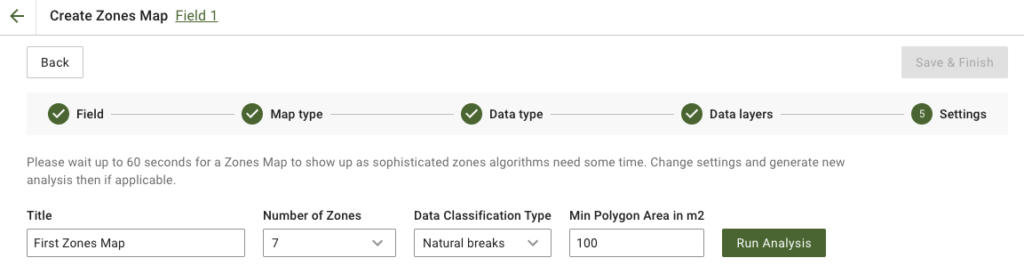
4. 次の手順では、タイトルを編集したり、ゾーン数を変更したり、 [データ分類タイプを選択したり](/geopard-tutorials/jpn/tsu-webapuri/znmapputo/dtawo.md)、最小ポリゴン面積を平方メートル単位で設定したりできます。 **分析を実行** をクリックして進みます。
分析は、指定したパラメータによっては最大60秒かかる場合があります。
5. 完了したら、 **保存して完了**.
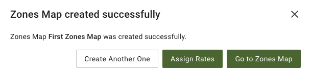
をクリックします。保存後、次のメッセージが表示されます。
別のゾーンマップを作成したり、散布量を割り当てたり、先ほど作成したゾーンマップを開いたりできます。開くと、同様の画面が表示されます。
---
# Agent Instructions
This documentation is published with GitBook. GitBook is the documentation platform designed so that both humans and AI agents can read, navigate, and reason over technical content effectively. Learn more at gitbook.com.
## Querying This Documentation
If you need additional information that is not directly available in this page, you can query the documentation by asking a question.
Perform an HTTP GET request on the following URL with the `ask` and `goal` query parameters:
```
GET https://docs.geopard.tech/geopard-tutorials/jpn/tsu-webapuri/znmapputo/dtawotteznmappuwo.md?ask=&goal=
```
`ask` is the immediate question: it should be specific, self-contained, and written in natural language.
`goal` is what the user is ultimately trying to achieve, the reason they need the answer. Sharing it helps GitBook give you a better, more relevant answer. A goal is most helpful when it describes the outcome the user wants rather than restating the question. For example, with `ask=how do I create an API token`, a goal like `automate deployments from our CI pipeline` lets GitBook tailor the answer to that use case.
The response will contain a direct answer to the question and relevant excerpts and sources from the documentation.
Use this mechanism when the answer is not explicitly present in the current page, you need clarification or additional context, or you want to retrieve related documentation sections.