> For the complete documentation index, see [llms.txt](https://docs.geopard.tech/geopard-tutorials/llms.txt). Markdown versions of documentation pages are available by appending `.md` to page URLs; this page is available as [Markdown](https://docs.geopard.tech/geopard-tutorials/jpn/tsu-webapuri/zones-maps-and-analytics/using-data-classification.md).

# データ分類を使用

AUTO、Natural Breaks、Equal Interval、Equal Count、Spatially Localized など、GeoPardの分類手法がゾーンマップにどう反映されるかを学びます。

データ分類は、地理データの分析と可視化における重要なステップです。GeoPardには、ユーザーがデータを効果的に理解し、解釈できるよう、複数の分類方法が用意されています。GeoPardでよく使われる方法は、自動分類、自然分類、等間隔分類、等数分類（面積）、空間局所分類です。各方法は用途に応じて使い分けます。以下で説明します。

## AUTO classification

自動分類では、適切な分類方法が選択されます **データの分布とゾーンの面積に基づいて**。分類方法を手動で比較する際の試行錯誤を減らし、より早く実用的なゾーンマップを作成できます。

このオプションは、まず適切な出発点を得て、マップ作成の時間を短縮したい場合に便利です。保存する前に結果を確認し、ほかのゾーン設定を調整することもできます。

<figure><img src="https://1993076779-files.gitbook.io/~/files/v0/b/gitbook-x-prod.appspot.com/o/spaces%2FYICBELdyAXXebKAzfLOR%2Fuploads%2F9w5QnaWrwVXAXPQTAw5L%2Fimage.png?alt=media&amp;token=b4c57f60-c506-4454-ab3e-e0525235975f" alt=""><figcaption><p>AUTO classification</p></figcaption></figure>

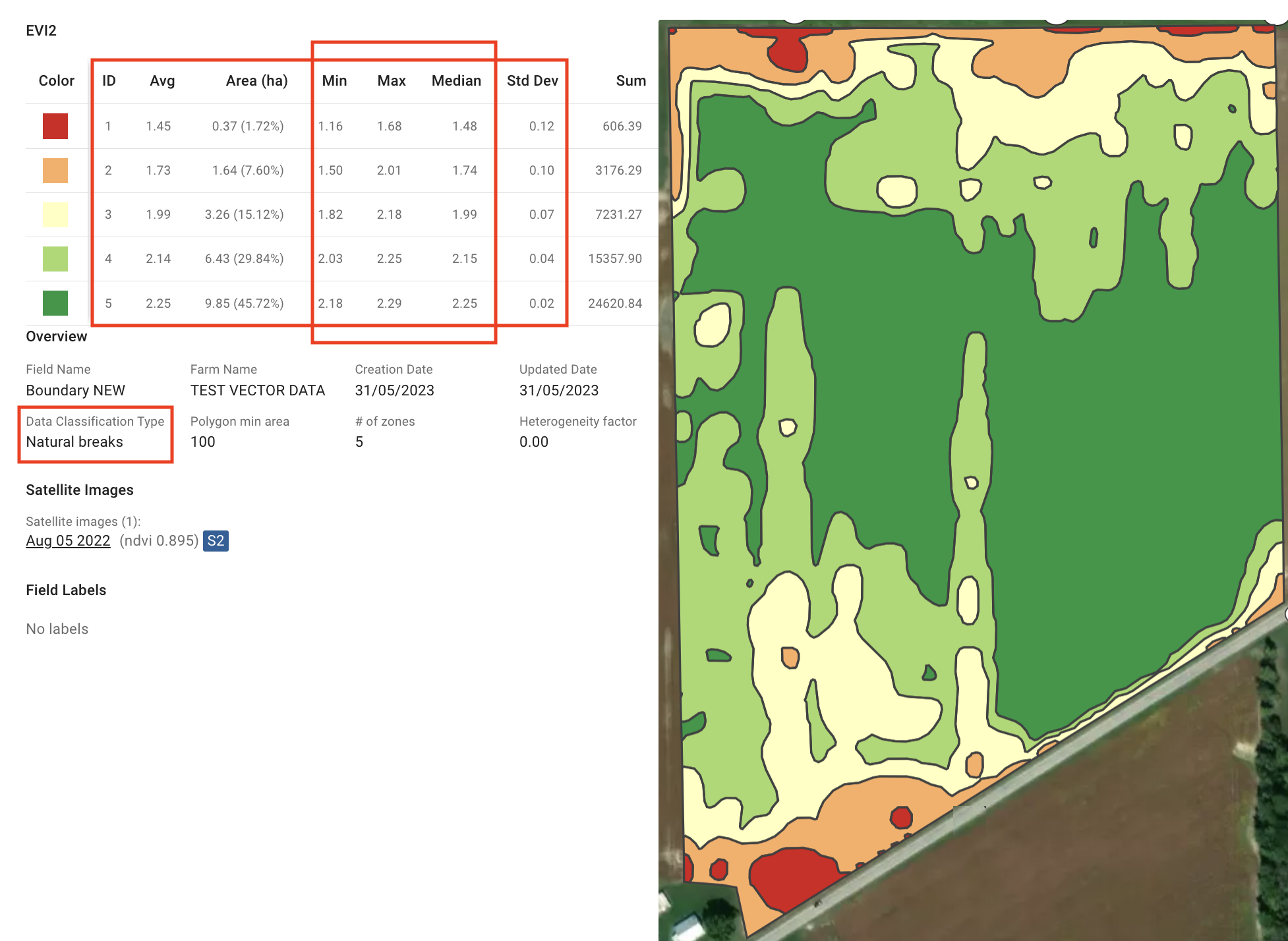
## 1. 自然分類

自然分類では、データ分布に見られる「自然な」境界値を特定し、データを明確なグループに分けます。クラス間の差を最大化し、各クラス内の差を最小化します。自然分類は、明確なパターンや集まりがあるデータに適しており、効果的な探索と分析に役立ちます。

<figure><img src="https://1993076779-files.gitbook.io/~/files/v0/b/gitbook-x-prod.appspot.com/o/spaces%2FYICBELdyAXXebKAzfLOR%2Fuploads%2FQzmD8cm9fyq0vTDYwxvq%2Fimage.png?alt=media&amp;token=4cf3e432-cbe6-459b-8fd6-75e7cb540024" alt=""><figcaption><p>自然分類</p></figcaption></figure>

## 2. 等間隔分類

等間隔分類では、データの範囲を同じ幅の区間に分割します。データ分布をバランスよく表現できるため、各区間内の値を簡単に解釈し、比較できます。等間隔分類は、明確なパターンがなく、均等に分布したデータに適しています。

<figure><img src="https://1993076779-files.gitbook.io/~/files/v0/b/gitbook-x-prod.appspot.com/o/spaces%2FYICBELdyAXXebKAzfLOR%2Fuploads%2FkOZpBpxYxxyhGVbicPLO%2Fimage.png?alt=media&amp;token=0f1211c8-2ac2-4786-a0e8-ed8ae7ffd843" alt=""><figcaption><p>等間隔分類</p></figcaption></figure>

## 3. 等数（面積）分類

等数分類では、各クラスに含まれるデータ値の数が等しくなります。データの偏りや分布の不均一さがある場合でも、バランスの取れた表現を維持できます。等数分類を使うと、圃場や地域間で公平に比較でき、一貫性のある分析と可視化が可能になります。

面積が比較的均等なゾーンを作成することを目指しますが、丸め処理やゾーン品質の向上処理によって、わずかな差が生じることがあります。そのため、EVI2、MCARI1、WDRVIなど、より粒度の高い植生指数を使用すると、より精度の高い結果が得られます。また、 [ゾーンの最終的な形状は、精度を高めるために微調整されます](https://geopard.tech/blog/432ca9jhnt-zones-quality/).

<figure><img src="https://1993076779-files.gitbook.io/~/files/v0/b/gitbook-x-prod.appspot.com/o/spaces%2FYICBELdyAXXebKAzfLOR%2Fuploads%2FKimgcw9kK0ED2uGagkEM%2Fimage.png?alt=media&amp;token=31e7fd08-ecec-4253-ac0a-582edf368bdc" alt=""><figcaption><p>等数（面積）分類</p></figcaption></figure>

## 4. 空間局所分類

空間局所分類では、データを地理空間的にクラスタリングし、局所的なゾーンを作成します。主な用途は土壌サンプリング用ゾーンの計画で、圃場を管理しやすい区域に効率的に分割できます。

柔軟性を高めるため、空間局所分類には次の3つのオプションがあります。 **空間方向**, **価値重視に向けて**、および **バランス型**.

### 4.1. 空間的に局所化されたバランス型の選択肢

この **バランス型の** 選択肢は、両者の中間的なアプローチを提供します。 **空間重視に向けて** と **価値重視に向けて**。地理的な近接性とデータ値の類似性のバランスを取ったクラスターで、ゾーンマップを作成します。この方法は、空間的なまとまりとデータの一貫性の両方が重要な場合に適しています。

<figure><img src="https://1993076779-files.gitbook.io/~/files/v0/b/gitbook-x-prod.appspot.com/o/spaces%2FYICBELdyAXXebKAzfLOR%2Fuploads%2FHkWvnjWzBOiljEnXQOhU%2Fimage.png?alt=media&amp;token=c5bd0315-ed78-4638-b219-3dac4abde057" alt=""><figcaption><p>空間局所型分類（バランス型オプション）</p></figcaption></figure>

### 4.2. 空間局所型の「値寄り」

次の **値寄り** 空間局所型分類の「値寄り」オプションでは、地理的な近接性ではなくデータ値に基づいてゾーンをクラスター化します。植生や土壌の品質など、属性が似ているエリアをまとめ、各ゾーン内のデータの一貫性を最も重視したゾーンマップを作成します。

<figure><img src="https://1993076779-files.gitbook.io/~/files/v0/b/gitbook-x-prod.appspot.com/o/spaces%2FYICBELdyAXXebKAzfLOR%2Fuploads%2FF7h0AB4cF7xbWCmA7PmK%2Fimage.png?alt=media&amp;token=5e9d6b86-5f7c-4acf-9990-e4c2a7a746c1" alt=""><figcaption><p>空間局所型分類（「値寄り」オプション）</p></figcaption></figure>

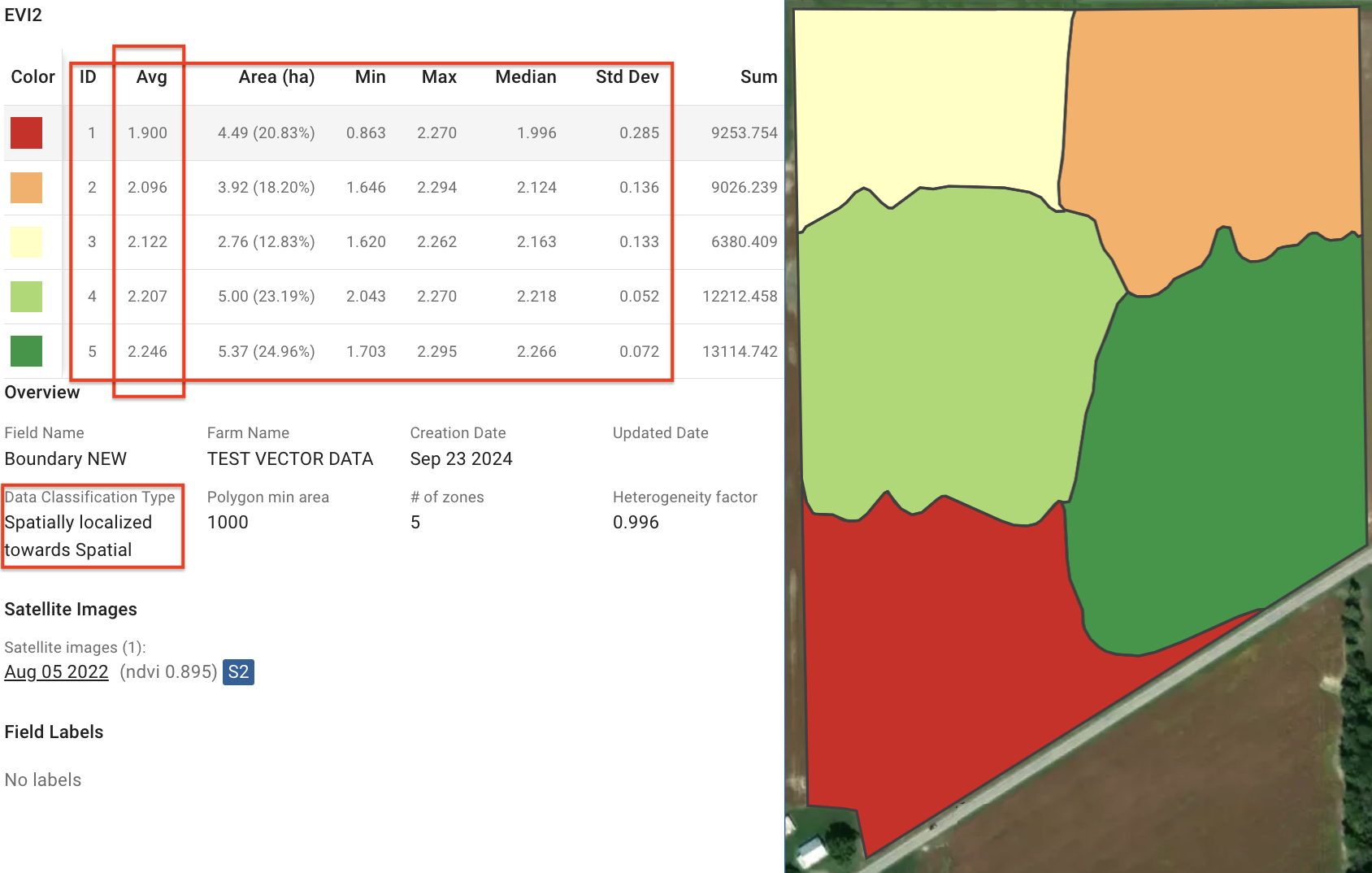
### 4.3. 空間局所型の「空間寄り」

次の **空間寄り** 空間局所型分類のオプションは、地理的により集中したゾーンの作成に重点を置きます。近接性を優先し、各ゾーンが空間的にコンパクトになるようクラスタリングしたゾーンマップを作成します。物流や空間サンプリングなど、物理的な位置が最も重要となる場合に最適です。

<figure><img src="https://1993076779-files.gitbook.io/~/files/v0/b/gitbook-x-prod.appspot.com/o/spaces%2FYICBELdyAXXebKAzfLOR%2Fuploads%2FDh2CT0aMwFrdBdPSDhjg%2Fimage.png?alt=media&amp;token=808f32ce-22c6-4baf-8370-5b65177ea3bd" alt=""><figcaption><p>空間局所型分類（空間オプション寄り）</p></figcaption></figure>


---

# Agent Instructions
This documentation is published with GitBook. GitBook is the documentation platform designed so that both humans and AI agents can read, navigate, and reason over technical content effectively. Learn more at gitbook.com.

## Querying This Documentation
If you need additional information that is not directly available in this page, you can query the documentation by asking a question.

Perform an HTTP GET request on the following URL with the `ask` and `goal` query parameters:

```
GET https://docs.geopard.tech/geopard-tutorials/jpn/tsu-webapuri/zones-maps-and-analytics/using-data-classification.md?ask=<question>&goal=<user_goal>
```

`ask` is the immediate question: it should be specific, self-contained, and written in natural language.
`goal` is what the user is ultimately trying to achieve, the reason they need the answer. Sharing it helps GitBook give you a better, more relevant answer. A goal is most helpful when it describes the outcome the user wants rather than restating the question. For example, with `ask=how do I create an API token`, a goal like `automate deployments from our CI pipeline` lets GitBook tailor the answer to that use case.

The response will contain a direct answer to the question and relevant excerpts and sources from the documentation.

Use this mechanism when the answer is not explicitly present in the current page, you need clarification or additional context, or you want to retrieve related documentation sections.