> For the complete documentation index, see [llms.txt](https://docs.geopard.tech/geopard-tutorials/llms.txt). Markdown versions of documentation pages are available by appending `.md` to page URLs; this page is available as [Markdown](https://docs.geopard.tech/geopard-tutorials/jpn/tsu-webapuri/john-deere-operations-center-integration.md).
# John Deere Operations Centerとの連携
GeoPardをOperations Centerに接続して、圃場境界、収量、播種実績、散布実績のデータをインポートし、処方箋をファイルまたは作業計画として送信します。
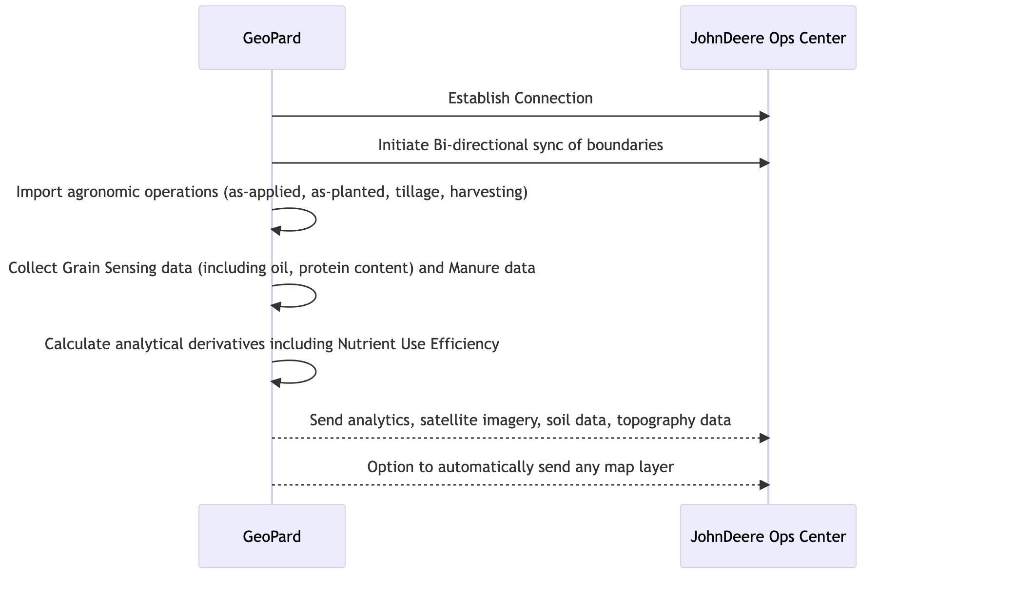
GeoPardはJohn Deere Operations Centerと双方向で連携します。圃場境界、収量、播種実績、施用実績、耕起データを取り込み、処方マップ(ファイルまたは作業計画として)、圃場境界、マップレイヤー、施用実績をOperations Centerに送信します。John Deereのログイン情報で接続し、GeoPardによる読み取りを許可する組織を選択します。コンサルタントは、複数の農家の組織を1つのGeoPardアカウントに接続できます。
{% hint style="success" %}
John Deereアカウントで登録して、GeoPardで圃場を確認しましょう。 [無料で始める](https://app.geopard.tech/auth/sign-up?utm_source=docs\&utm_medium=cta\&utm_campaign=john-deere-operations-center-integration)
{% endhint %}
John Deere Operations Centerのアカウントをお持ちの場合、GeoPardと簡単に連携して、追加機能やメリットを活用できます。まずは、 app.geopard.tech にアクセスし、100ヘクタール(250エーカー)を利用できる無料トライアルに登録してください。
### 双方向自動連携でサポートされる機能
1. [MyJohnDeere Operations Centerに接続](https://docs.geopard.tech/geopard-tutorials/jpn/tsu-webapuri/john-deere-operations-center-integration/2.-connect-to-john-deere-operations-center.md) — GeoPardを使用
2. [MyJohnDeereの組織に接続](https://docs.geopard.tech/geopard-tutorials/jpn/tsu-webapuri/john-deere-operations-center-integration/3.-connect-to-john-deere-organizations.md)
3. [MyJohnDeere Operations Centerからインポート ](https://docs.geopard.tech/geopard-tutorials/jpn/tsu-webapuri/john-deere-operations-center-integration/4.-import-into-geopard-from-john-deere-operations-center.md)— GeoPardへ
* 圃場境界
* 作業マップ
* *播種(播種実績)*
* *施用実績:施用* 肥料・作物保護剤・生育調整剤の施用量
* *GrainSensingデータ*( [John Deere HarvestLab™ 3000](https://www.deere.com/en/technology-products/precision-ag-technology/data-management/harvest-lab-constituent-sensing/)
* *堆肥データ*
* *収穫*
* *耕起*
* *過去データの完全なアーカイブ*
4. GeoPardからJohn Deere Operations Centerにエクスポート
* [圃場境界](https://docs.geopard.tech/geopard-tutorials/jpn/tsu-webapuri/john-deere-operations-center-integration/7.-export-field-boundaries-to-john-deere-operations-center.md)
* [John Deere Operations Centerと圃場を同期](https://docs.geopard.tech/geopard-tutorials/jpn/tsu-webapuri/john-deere-operations-center-integration/11.-synchronize-a-field-with-john-deere-operations-center.md)
* [作業計画としての可変施肥・散布マップ](https://docs.geopard.tech/geopard-tutorials/jpn/tsu-webapuri/john-deere-operations-center-integration/8.-export-rx-maps-to-john-deere-operations-center-as-work-plans.md) (
* 可変播種
* 可変施肥(近日公開)
* 作物保護(近日公開)
* 植物成長調整剤(近日公開)
* [ファイルとしてのVRAマップ](https://docs.geopard.tech/geopard-tutorials/jpn/tsu-webapuri/john-deere-operations-center-integration/6.-export-rx-maps-to-john-deere-operations-center-as-files.md) 向け
* 可変播種
* 可変施肥
* 作物保護
* 植物成長調整剤
* 管理ゾーン(例:圃場ポテンシャルマップ)
* LiDARまたはGPSデータに基づく地形マップ
* 土壌サンプリングまたはスキャンによる土壌マップ([電気伝導度](https://geopard.tech/blog/k9s011204i-high-density-sensor-data/)、Veris/EM38/DualEM、 [SoilOptix](https://geopard.tech/blog/brrck2udr1-soiloptix-data-analysis-in-precision-agr/), [TopSoilMapper](https://geopard.tech/blog/agte3p8ec1-analyze-geoprospectors-topsoilmapper-dat/)).
* Landsat、Sentinel、Planetの各プロバイダーが提供する、RGB、NIR、コントラスト強調植生画像を含む衛星画像
* 数式に基づく分析; [詳細はこちら](https://geopard.tech/blog/equation-based-analytics-precision/) NUE、ROIマップ、目標値と実測値の比較計算について
5. [データの自動同期](https://docs.geopard.tech/geopard-tutorials/jpn/tsu-webapuri/john-deere-operations-center-integration/5.-configure-automated-data-sync.md)\
以下の機能は、GeoPardのJohn Deere連携ページで個別に設定できます。
* GeoPardは新たに収集された作業マップを継続的に確認し、自動的にダウンロードして既存の圃場境界に関連付けます。\
追跡可能な作業マップには、次のものがあります。 *播種*, *散布*, *収穫*、および *耕起*.
* GeoPardは、ユーザーが変更した *圃場境界* をすべてOps Centerに反映します。
* GeoPardは、 *地形マップ*, *土壌マップ* サンプルやスキャナーから取得したデータ、 *管理ゾーン*、および *数式マップ* を、ビジュアルマップレイヤーとしてJohn Deere Operations Centerに送信します。
6. Climate FieldViewとのデータ接続\
John Deere Operations Centerを介して、GeoPardとFieldView間でほぼリアルタイムのデータ交換を行います。GeoPardは、過去のアーカイブを含むFieldViewに保存された作業データを取り込み、圃場境界とVRAマップを送信します。
{% hint style="success" %}
John Deereアカウントで登録して、GeoPardで圃場を確認しましょう。 [無料で始める](https://app.geopard.tech/auth/sign-up?utm_source=docs\&utm_medium=cta\&utm_campaign=john-deere-operations-center-integration)
{% endhint %}
---
# Agent Instructions
This documentation is published with GitBook. GitBook is the documentation platform designed so that both humans and AI agents can read, navigate, and reason over technical content effectively. Learn more at gitbook.com.
## Querying This Documentation
If you need additional information that is not directly available in this page, you can query the documentation by asking a question.
Perform an HTTP GET request on the following URL with the `ask` and `goal` query parameters:
```
GET https://docs.geopard.tech/geopard-tutorials/jpn/tsu-webapuri/john-deere-operations-center-integration.md?ask=&goal=
```
`ask` is the immediate question: it should be specific, self-contained, and written in natural language.
`goal` is what the user is ultimately trying to achieve, the reason they need the answer. Sharing it helps GitBook give you a better, more relevant answer. A goal is most helpful when it describes the outcome the user wants rather than restating the question. For example, with `ask=how do I create an API token`, a goal like `automate deployments from our CI pipeline` lets GitBook tailor the answer to that use case.
The response will contain a direct answer to the question and relevant excerpts and sources from the documentation.
Use this mechanism when the answer is not explicitly present in the current page, you need clarification or additional context, or you want to retrieve related documentation sections.