{% endstep %}
{% endstepper %}
## オプション B — 方程式ベース
[方程式ベースの](https://docs.geopard.tech/geopard-tutorials/jpn/tsu-webapuri/equation-based-analytics.md) マップも可変量除草剤散布マップとして利用できます。
## 経済効果と投資収益率(ROI)
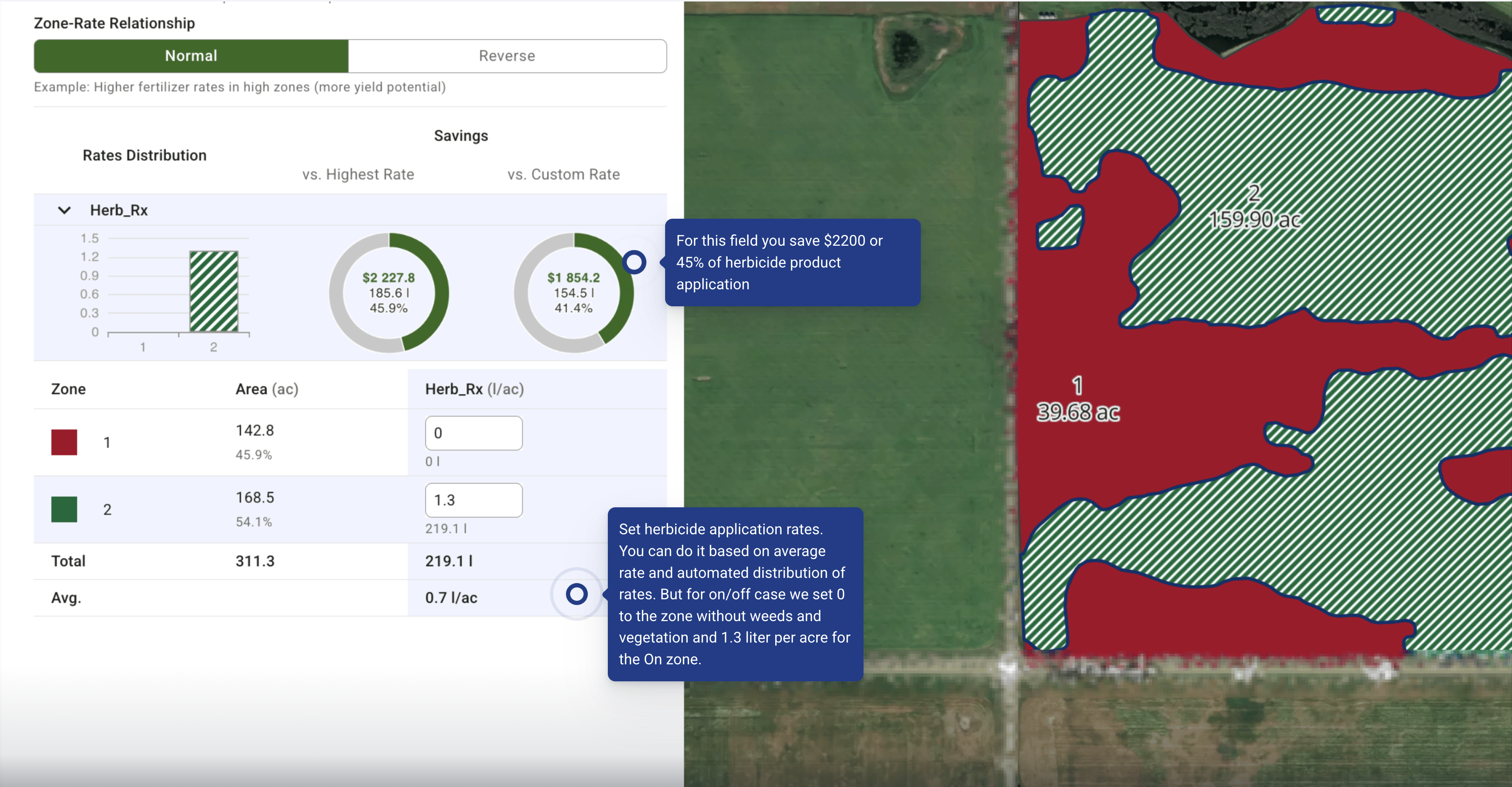
| 指標 | 値 |
| ---------------------------------- | ----------------------------------------------------: |
| 圃場面積 | **311.3 ac** |
| 可変量散布ゾーン(面積比) | **散布なし:** 142.8 ac(45.9%) • **散布あり:** 168.5 ac(54.1%) |
| 散布あり区域の散布量(除草剤) | **1.3 L/ac** |
| 可変量散布時の平均散布量 | **0.7 L/ac** |
| 一律散布の場合の総量(全農地に 1.3 L/ac) | **404.7 L** |
| 可変量散布時の総量(散布あり/なし) | **219.1 L** |
| **一律散布と比べた使用量の削減** | **185.6 L(45.9%)** |
| 1 リットルあたりの価格 | **$12.00/L** |
| **一律散布と比べた資材費の削減** | **$2 227.8** |
| **別シナリオ — 独自の「カスタム」散布量の組み合わせとの比較** | **154.5 L 削減 → $1 854.2** |
##
## Q\&A
* **画像の重ね合わせ表示**:画像とゾーンの表示を切り替え、畦畔や湿地を確認します。
* **現地確認**:圃場で、または高解像度のドローン/スマートフォン画像で、最大のパッチを3~5か所確認します。
* **境界のアーティファクト**:境界に筋状の模様が見られる場合は、 **境界バッファー(−3~−6 m)** を追加するか、しきい値を再設定します。
* **雲/影**:雲や影がある場合は、撮影日を変更するか、雲レイヤーを使ってマスクします。
* **パッチにノイズが多い** → **最小面積**を大きくするか、 **平滑化**を追加するか、 **Planet 3 m画像**.
***
## 推奨デフォルト値(圃場ごとに調整)
* **植生指数**:まずは [**OSAVI**](https://docs.geopard.tech/geopard-tutorials/jpn/tsu-webapuri/satellite-monitoring/indices-for-crops-and-soils.md) を使い、群落が閉じるまでは、 **CIred-edge** を **6~9葉期** 以降に試します。
* **最小パッチサイズ**: **セクション面積の2倍以上** (例:ブーム幅12 m、セクション幅3 mの場合 ⇒ 約72 m²)。制御を安定させるには、値を切り上げます。
* **バッファー**: **−3 m** 圃場境界からの距離; **散布禁止区域** は製品ラベル/規制に従います。
***
## コントローラー別のエクスポートのヒント
* **SHP**:属性 `RATE` (数値型)を確認します。
* **ISOXML**:操作タイプの名称、 **製品**、および **単位** は、端末が求める表記と完全に一致させます。
* **John Deere Ops Center**:数クリックでOps Centerに [Rxファイル](https://docs.geopard.tech/geopard-tutorials/jpn/tsu-webapuri/export-download/export-to-myjohndeere.md) または [WorkPlan](https://docs.geopard.tech/geopard-tutorials/jpn/tsu-webapuri/john-deere-operations-center-integration/8.-export-rx-maps-to-john-deere-operations-center-as-work-plans.md)
***
## コンプライアンスと農学上の注意事項
* 従ってください **ラベルに記載された散布量**, **緩衝地帯**, **風** および **ドリフト** に関する規則。
* スポット散布の成功率は、 **出芽後7~14日でこのワークフローを再実行すると、** 散布漏れを見つけやすくなり、向上します。
* 有効性を証明し、次回のしきい値を調整できるよう、 **作業前後の** 写真を一組保管してください。
---
# Agent Instructions
This documentation is published with GitBook. GitBook is the documentation platform designed so that both humans and AI agents can read, navigate, and reason over technical content effectively. Learn more at gitbook.com.
## Querying This Documentation
If you need additional information that is not directly available in this page, you can query the documentation by asking a question.
Perform an HTTP GET request on the following URL with the `ask` and `goal` query parameters:
```
GET https://docs.geopard.tech/geopard-tutorials/jpn/nong-xue/crop-protection/weed-patches-detection-and-herbicide-vra-rx-map.md?ask=&goal=
```
`ask` is the immediate question: it should be specific, self-contained, and written in natural language.
`goal` is what the user is ultimately trying to achieve, the reason they need the answer. Sharing it helps GitBook give you a better, more relevant answer. A goal is most helpful when it describes the outcome the user wants rather than restating the question. For example, with `ask=how do I create an API token`, a goal like `automate deployments from our CI pipeline` lets GitBook tailor the answer to that use case.
The response will contain a direct answer to the question and relevant excerpts and sources from the documentation.
Use this mechanism when the answer is not explicitly present in the current page, you need clarification or additional context, or you want to retrieve related documentation sections.
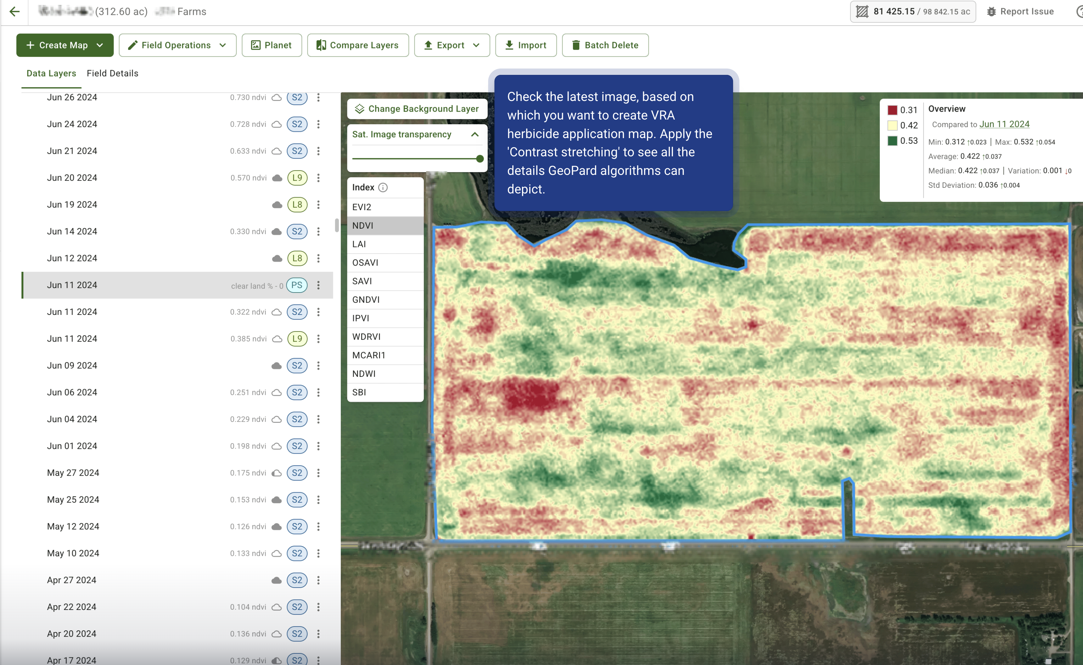

 .
{% endhint %}
{% @arcade/embed url="