> For the complete documentation index, see [llms.txt](https://docs.geopard.tech/geopard-tutorials/llms.txt). Markdown versions of documentation pages are available by appending `.md` to page URLs; this page is available as [Markdown](https://docs.geopard.tech/geopard-tutorials/it/tour-del-prodotto-app-web/mappe-di-zone-e-analisi/fattore-di-variazione-relativa.md).
# Fattore di variazione relativa
Quantifica la variazione spaziale rispetto alla media per confrontare la variabilità tra appezzamenti e set di dati.
Rilevare i cambiamenti avvenuti nel campo durante le ultime una-due settimane o uno-due mesi, o persino nell’arco di un paio d’anni, aiuta a ottenere informazioni sullo sviluppo colturale.
Il fattore di variazione relativa o l’Indice di Variazione Relativa può essere usato per:
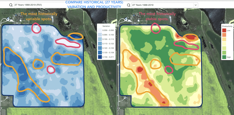
* individuare zone con prestazioni simili nell’arco di 5-10-20 anni e collocare le prove in aree con condizioni simili per ridurre la probabilità di errore
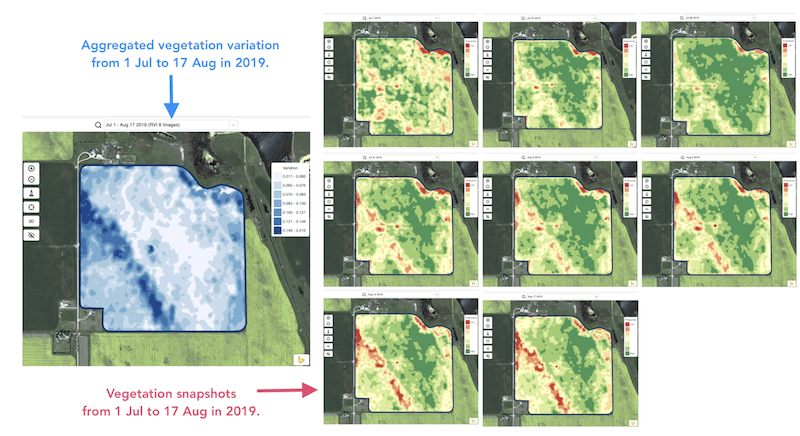
* monitorare i cambiamenti durante la stagione e valutare le prestazioni della coltura nel corso della crescita
* riconoscere le aree danneggiate dopo un evento meteorologico avverso o un attacco di malattia o parassiti e calcolare le superfici danneggiate
* rilevare la differenza tra le ultime due immagini e controllare le prestazioni della coltura.
L’Indice di Variazione Relativa (RVI) di GeoPard copre tutti questi casi e molti altri. L’RVI fornirà maggiori informazioni sullo sviluppo colturale se utilizzato insieme e in combinazione con le zone di gestione stagionali e storiche.
Basta scegliere il tuo campo e le immagini satellitari per monitorare i cambiamenti al loro interno e ottenere informazioni su ogni punto del tuo campo.
---
# Agent Instructions
This documentation is published with GitBook. GitBook is the documentation platform designed so that both humans and AI agents can read, navigate, and reason over technical content effectively. Learn more at gitbook.com.
## Querying This Documentation
If you need additional information that is not directly available in this page, you can query the documentation by asking a question.
Perform an HTTP GET request on the following URL with the `ask` and `goal` query parameters:
```
GET https://docs.geopard.tech/geopard-tutorials/it/tour-del-prodotto-app-web/mappe-di-zone-e-analisi/fattore-di-variazione-relativa.md?ask=&goal=
```
`ask` is the immediate question: it should be specific, self-contained, and written in natural language.
`goal` is what the user is ultimately trying to achieve, the reason they need the answer. Sharing it helps GitBook give you a better, more relevant answer. A goal is most helpful when it describes the outcome the user wants rather than restating the question. For example, with `ask=how do I create an API token`, a goal like `automate deployments from our CI pipeline` lets GitBook tailor the answer to that use case.
The response will contain a direct answer to the question and relevant excerpts and sources from the documentation.
Use this mechanism when the answer is not explicitly present in the current page, you need clarification or additional context, or you want to retrieve related documentation sections.