> For the complete documentation index, see [llms.txt](https://docs.geopard.tech/geopard-tutorials/llms.txt). Markdown versions of documentation pages are available by appending `.md` to page URLs; this page is available as [Markdown](https://docs.geopard.tech/geopard-tutorials/it/tour-del-prodotto-app-web/export-download.md).
# Esporta / Scarica
GeoPard non blocca i tuoi dati. Puoi scaricare in qualsiasi momento i dati grezzi e le analisi, in blocco, tramite l’interfaccia utente o l’API.
Per i formati di dati esportabili supportati, consulta la [pagina Compatibilità dei dati](https://geopard.tech/data-compatibility/).
{% hint style="success" %}
Prova a esportare mappe e prescrizioni per i tuoi campi: [Inizia gratis](https://app.geopard.tech/auth/sign-up?utm_source=docs\&utm_medium=cta\&utm_campaign=export-download)
{% endhint %}
Raven Slingshot e Viper Pro 4 – shapefile
Trimble – shapefile e ISOXML
Dati John Deere GS3 e GS4 ([dettagli GS3](https://stellarsupport.deere.com/site_media/pdf/en/manuals/gs3_2630/ompfp13946_j3_19_25oct13_402dcy.pdf), [dettagli GS4](https://www.deere.com/assets/pdfs/common/stellarsupport/Gen4CommandCenter_ReleaseNotes_16-1_English.pdf))
John Deere – integrato con MyJD Ops Center; scopri i dettagli nel nostro post sul blog
AGCO – ISOXML e shapefile
CNH – supporto per ISOXML/shapefile:\
\&#xNAN;*CNH Voyager 2 o Case Pro 700 – ISOXML*\
\&#xNAN;*Monitor Case IH – versione firmware 30.6.0.0 o successiva – compatibilità con gli shapefile* [dettagli](https://assets.cnhindustrial.com/caseih/NAFTA/NAFTAASSETS/Products/Advanced-Farming-Systems/Brochures/AFS%20Precision%20Farming%20Catalog_05-07-2019_PM-18308.pdf)
Topcon/TAP – supporto per shapefile
Monitor Mueller – supporto per ISOXML/shapefile, [dettagli](https://www.mueller-elektronik.de/pm_manuals/TRACK-Leader%20f%C3%BCr%20Tasten-Terminals/de/701717643.html)
ISOXML (Claas, Topcon, Dickey John, CNH e altri)
Monitor AgLeader – supporto per shapefile, [dettagli](https://www.agleader.com/blog/loading-prescription-files-into-ag-leader-integra-and-versa-displays/?locale=en)
 Amazone / Amatron – shapefile, ISOXML ([dettagli di Amatron 3](https://et.amazone.de/files/pdf/MG5560-EN-II.pdf), [dettagli di Amatron4](https://et.amazone.de/files/pdf/MG6010-EN-II.pdf))
GeoJSON – un formato generico di dati vettoriali. È supportato dalla maggior parte dei programmi GIS, tra cui Esri ArcGIS e QGIS. Disponibile per gli utenti API.
Shapefile – un formato generico di dati vettoriali. È supportato dalla maggior parte dei programmi GIS, tra cui Esri ArcGIS e QGIS.
API e widget per integrare le analisi GeoPard in altri sistemi.
### **Esportazione dei confini dei campi**
Per esportare uno shapefile del tuo campo o dei tuoi campi, usa **Esporta dati** e vai alla scheda **Scarica file** .
1. Espandi l'azienda agricola e il campo desiderati. Seleziona dall'albero il confine che vuoi esportare, quindi fai clic su **Scarica** oppure **Scarica selezionati** se vuoi esportare più livelli selezionati contemporaneamente.
Il confine selezionato verrà scaricato sul tuo computer come file .shp in un archivio .zip, che potrai caricare sulle macchine agricole.
### **Esportazione delle mappe delle zone**
GeoPard ti consente di esportare le mappe delle zone dei tuoi campi con applicazioni a dose variabile, per i flussi di lavoro dell'agricoltura di precisione.
Fai clic sulla voce di menu **Esporta dati** Quindi vai alla scheda **Scarica file** .
1. Espandi l'azienda agricola e il campo desiderati. Seleziona dall'albero le mappe delle zone che vuoi esportare, quindi fai clic su **Scarica** oppure **Scarica selezionati** se vuoi esportare più mappe selezionate contemporaneamente.
Le mappe delle zone selezionate verranno scaricate sul computer come file .shp in un archivio .zip, che puoi caricare sulle macchine agricole.
### Esportare le prove in campo
Le prove vengono esportate dalla relativa **Mappa delle zone**.
GeoPard esporta la prova insieme alla Mappa delle zone come un unico layer pronto per l’applicazione. In questo modo, i trattamenti mantengono il riferimento geografico e sono pronti per l’esecuzione con le macchine agricole o per analisi successive.
Segui questa procedura:
1. Apri il campo e vai alla **Mappa delle zone** che contiene la prova salvata.
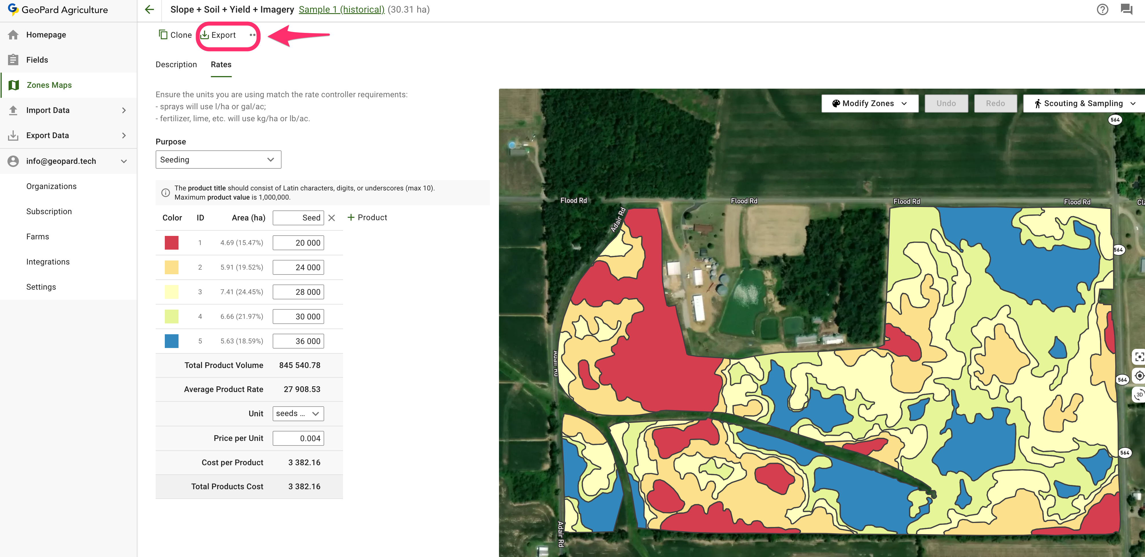
2. Fai clic su **Esporta** nella pagina della Mappa delle zone.
3. Scegli il formato di output desiderato:
* **ISOXML** per terminali e controller compatibili
* **Esportazione John Deere** quando vuoi inviare la prescrizione a Operations Center
* **Shapefile** quando ti serve un file vettoriale compatibile con un sistema GIS o un controller
4. Scarica il file esportato e caricalo nel flusso di lavoro delle tue attrezzature.
{% hint style="info" %}
Le prove non vengono esportate come layer autonomo separato. Vengono esportate insieme alla relativa Mappa delle zone.
{% endhint %}
Pagine utili correlate:
* [Progettazione e creazione di prove in campo](https://docs.geopard.tech/geopard-tutorials/it/tour-del-prodotto-app-web/on-farm-trials-design-and-creation.md)
* [Esportare una mappa VRA in formato ISOXML](https://docs.geopard.tech/geopard-tutorials/it/tour-del-prodotto-app-web/export-download/export-vra-map-in-isoxml-format.md)
* [Esportare le mappe di prescrizione in John Deere Operations Center come file](https://docs.geopard.tech/geopard-tutorials/it/tour-del-prodotto-app-web/john-deere-operations-center-integration/6.-export-rx-maps-to-john-deere-operations-center-as-files.md)
* [Esportare le mappe di prescrizione in John Deere Operations Center come piani di lavoro](https://docs.geopard.tech/geopard-tutorials/it/tour-del-prodotto-app-web/john-deere-operations-center-integration/8.-export-rx-maps-to-john-deere-operations-center-as-work-plans.md)
### Esportare una mappa VRA in formato ISOXML
GeoPard supporta l’esportazione nei formati di dati ISOBUS / ISOXML ([ISO 11783-1:2017](https://www.iso.org/standard/57556.html)).
Procedura di esportazione:
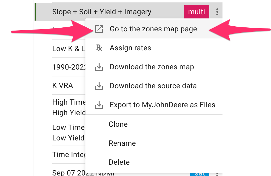
1. Fai clic su «Vai alla pagina della mappa delle zone»
2. Fai clic su «Esporta»
3. Scarica ISOXML
4. Il file scaricato `.zip` dovrebbe avere questo aspetto. Contiene tutte e tre le varianti ISOXML. Consulta le specifiche del monitor per scegliere quella corretta.
Il file ZIP dell’esportazione ISOXML risultante ha questo aspetto
### **Esporta in MyJohnDeere**
Gli utenti GeoPard possono esportare dati come le prescrizioni Rx e altri layer cartografici in John Deere Operations Center.
Puoi esportare i set di dati tramite la voce di menu **Esporta dati** Seleziona **Su MyJohnDeere**.
1. Seleziona un'organizzazione di destinazione che GeoPard utilizzerà per caricare i file. Se l'organizzazione corretta non è disponibile, vai al **Qui puoi modificare il collegamento dell'organizzazione** e aggiungerla. Se l'organizzazione John Deere è disabilitata (il nome è visualizzato in grigio), aggiungi l'accesso nel John Deere Operations Center. Fai clic su **Avanti**.
2. Seleziona gli asset che GeoPard caricherà nel John Deere Operations Center. Puoi filtrare gli asset. Dopo aver selezionato tutti gli asset, puoi caricarli tutti facendo clic sul pulsante **Esporta tutto** oppure caricare singoli asset facendo clic sul pulsante **Esporta** .
Dopo aver fatto clic, viene visualizzato un messaggio con l'esito dell'operazione. Il risultato sarà quindi disponibile nel John Deere Operations Center.
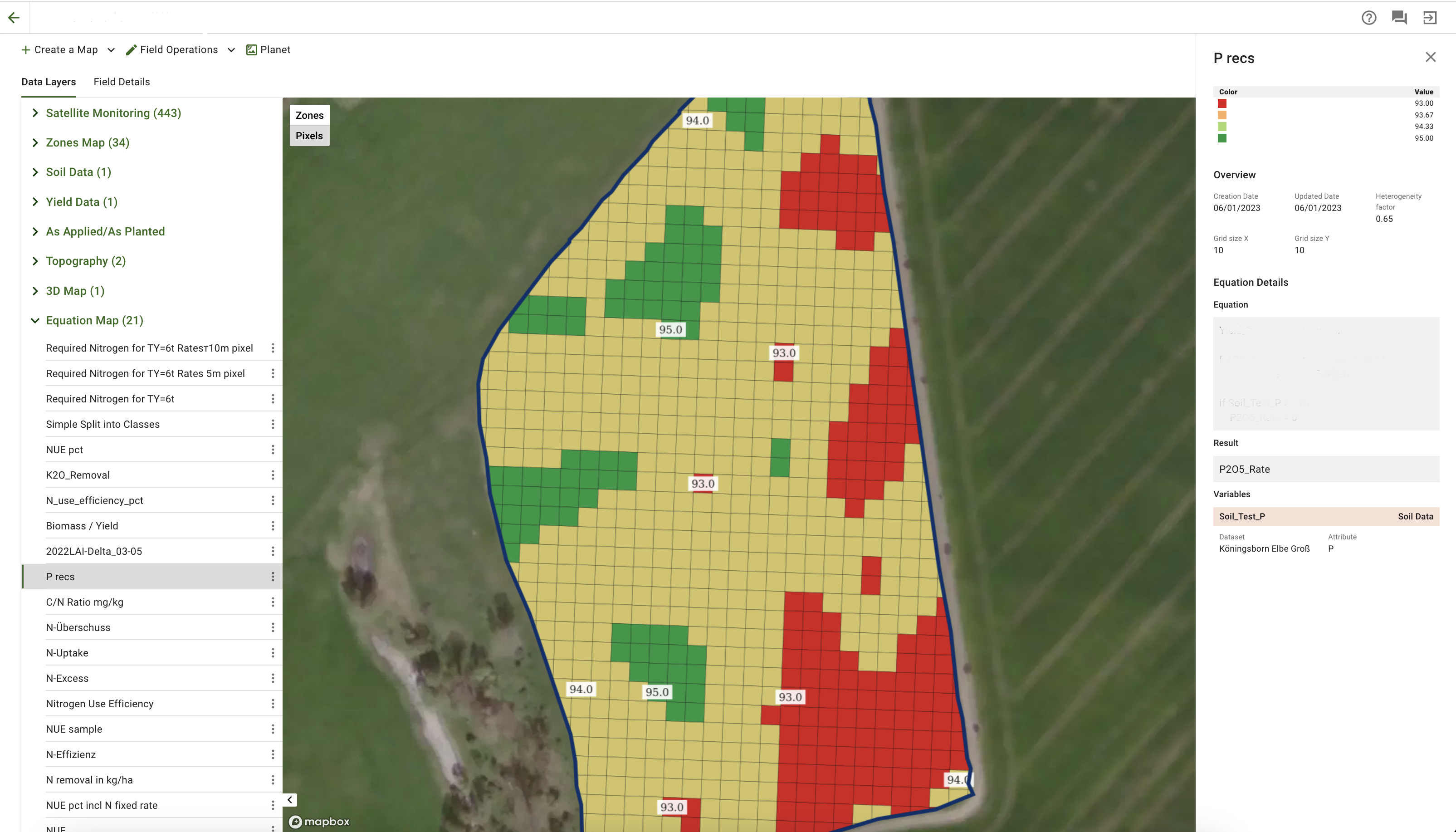
### **Esportare le equazioni**
Ora è possibile scaricare la Mappa delle equazioni con i dati raggruppati in MultiPolygon in base al loro valore.\
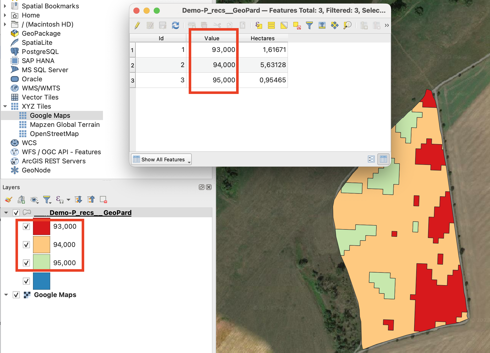
La Mappa delle equazioni con più dosi viene esportata come segue:
In questo modo la macchina non deve cambiare zona troppo spesso.\
\
Puoi scaricare archivi di questo tipo usando:\
\
\
Nota: non abbiamo ancora modificato il flusso «Esporta in My JohnDeere come file» per supportare questa funzionalità.
---
# Agent Instructions
This documentation is published with GitBook. GitBook is the documentation platform designed so that both humans and AI agents can read, navigate, and reason over technical content effectively. Learn more at gitbook.com.
## Querying This Documentation
If you need additional information that is not directly available in this page, you can query the documentation by asking a question.
Perform an HTTP GET request on the following URL with the `ask` and `goal` query parameters:
```
GET https://docs.geopard.tech/geopard-tutorials/it/tour-del-prodotto-app-web/export-download.md?ask=&goal=
```
`ask` is the immediate question: it should be specific, self-contained, and written in natural language.
`goal` is what the user is ultimately trying to achieve, the reason they need the answer. Sharing it helps GitBook give you a better, more relevant answer. A goal is most helpful when it describes the outcome the user wants rather than restating the question. For example, with `ask=how do I create an API token`, a goal like `automate deployments from our CI pipeline` lets GitBook tailor the answer to that use case.
The response will contain a direct answer to the question and relevant excerpts and sources from the documentation.
Use this mechanism when the answer is not explicitly present in the current page, you need clarification or additional context, or you want to retrieve related documentation sections.