> For the complete documentation index, see [llms.txt](https://docs.geopard.tech/geopard-tutorials/llms.txt). Markdown versions of documentation pages are available by appending `.md` to page URLs; this page is available as [Markdown](https://docs.geopard.tech/geopard-tutorials/it/suggerimenti-rapidi-gis/qgis-converti-csv-in-shp.md).
# QGIS: converti CSV in SHP
Converti i dati puntuali CSV in uno shapefile in QGIS per l'importazione in GeoPard e l'uso GIS.
Il tutorial aiuta a convertire CSV in SHP (shapefile). Di seguito sono riportati i passaggi su come farlo utilizzando [QGIS](https://www.qgis.org/en/site/) software desktop.
**IMPORTANTE**: I dati in formato CSV devono contenere `longitudine` e `latitudine` colonne per creare la corretta mappatura della georeferenziazione.
**FASE 1**: Avvia il processo di importazione usando "Layer" >> "Aggiungi layer" >> "Aggiungi layer di testo delimitato".
**FASE 2**: Configura i parametri di importazione e fai clic sul pulsante "Aggiungi".
1. Definisci il percorso del file CSV
2. Controlla il separatore di colonna, dovrebbe essere una virgola.
3. Controlla la prima riga. Di solito contiene i nomi degli attributi. Deve essere esclusa dall'analisi.
4. Seleziona le colonne del dataset con i dati di Latitudine (X) e Longitudine (Y).
5. Imposta il Sistema di Riferimento delle Coordinate. Di solito si usa ESPG:4326.
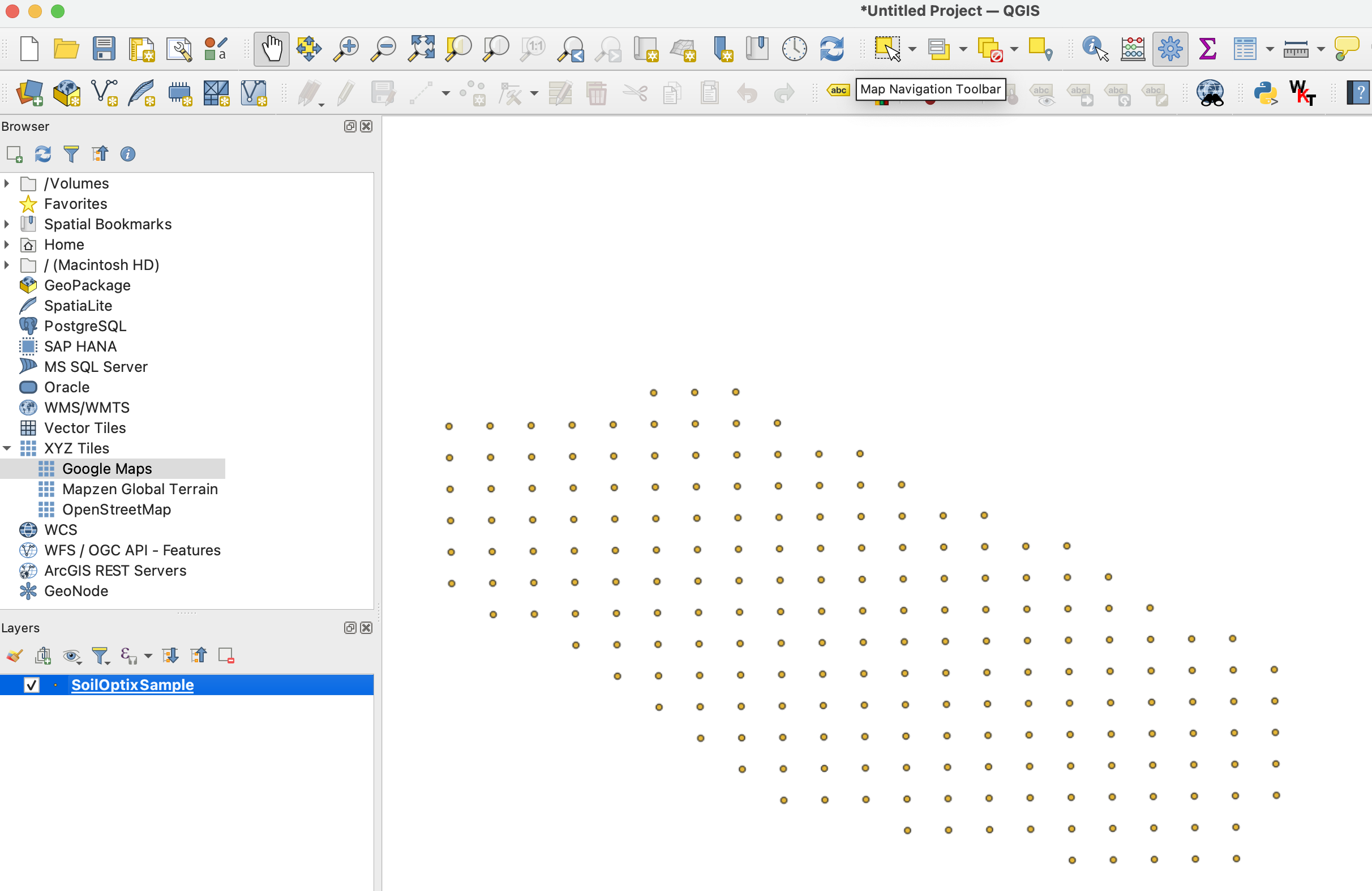
Il risultato atteso dopo **FASE 2** assomiglia a
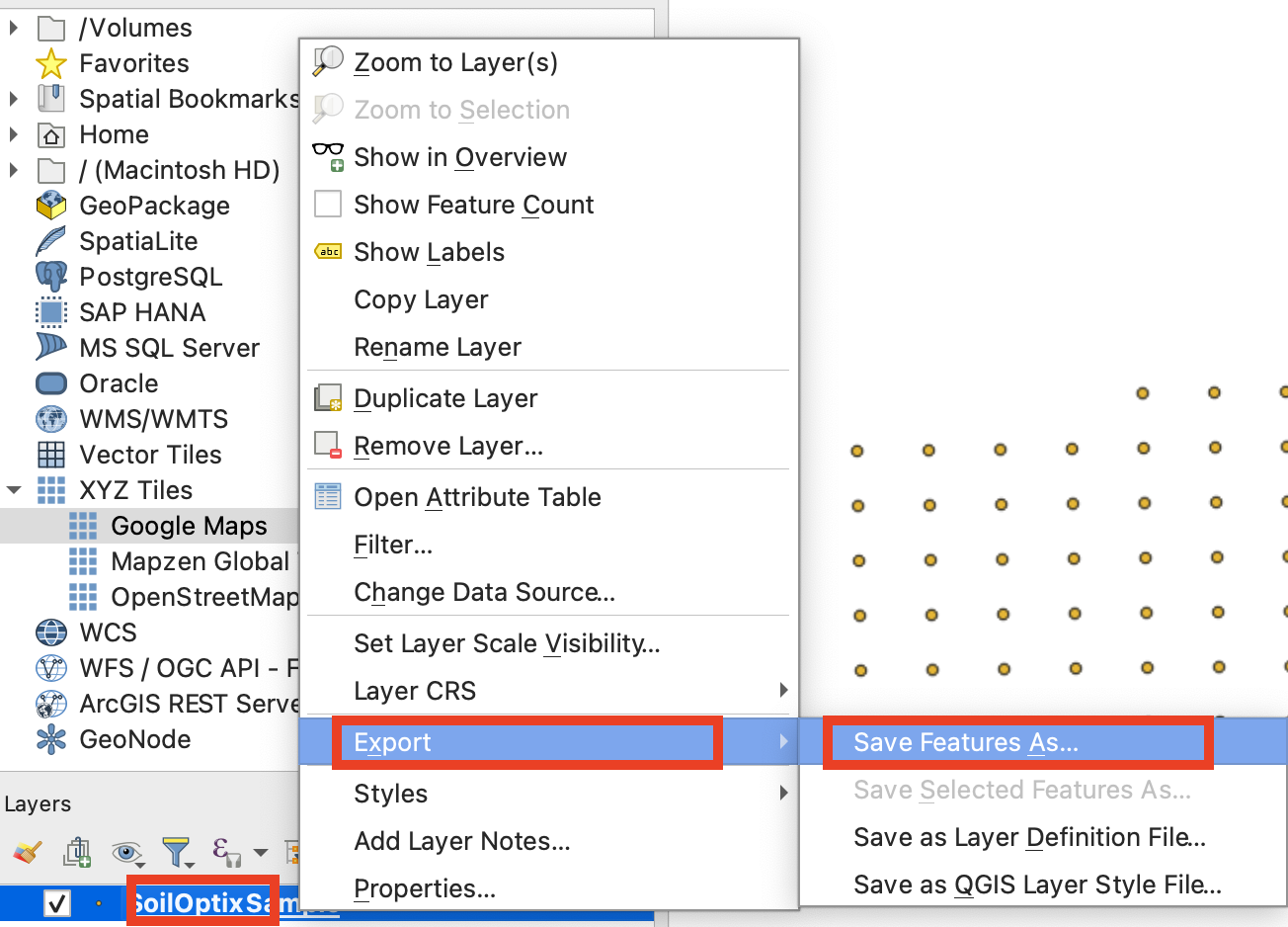
**FASE 3**: Avvia il flusso di esportazione tramite clic con il "Tasto destro del mouse" >> "Esporta" >> "Salva elementi come ..."
**FASE 4**: Configura le corrette opzioni di esportazione e fai clic su "Ok".
1. Imposta il percorso dello shapefile esportato.
2. Imposta il Sistema di Riferimento delle Coordinate (CRS) su ESPG:4326, che è accettato da GeoPard.
---
# Agent Instructions
This documentation is published with GitBook. GitBook is the documentation platform designed so that both humans and AI agents can read, navigate, and reason over technical content effectively. Learn more at gitbook.com.
## Querying This Documentation
If you need additional information that is not directly available in this page, you can query the documentation by asking a question.
Perform an HTTP GET request on the following URL with the `ask` and `goal` query parameters:
```
GET https://docs.geopard.tech/geopard-tutorials/it/suggerimenti-rapidi-gis/qgis-converti-csv-in-shp.md?ask=&goal=
```
`ask` is the immediate question: it should be specific, self-contained, and written in natural language.
`goal` is what the user is ultimately trying to achieve, the reason they need the answer. Sharing it helps GitBook give you a better, more relevant answer. A goal is most helpful when it describes the outcome the user wants rather than restating the question. For example, with `ask=how do I create an API token`, a goal like `automate deployments from our CI pipeline` lets GitBook tailor the answer to that use case.
The response will contain a direct answer to the question and relevant excerpts and sources from the documentation.
Use this mechanism when the answer is not explicitly present in the current page, you need clarification or additional context, or you want to retrieve related documentation sections.