> For the complete documentation index, see [llms.txt](https://docs.geopard.tech/geopard-tutorials/llms.txt). Markdown versions of documentation pages are available by appending `.md` to page URLs; this page is available as [Markdown](https://docs.geopard.tech/geopard-tutorials/hu/termektura-webalkalmazas/zones-maps-and-analytics/create-a-zones-map-using-satellite-imagery.md).
# Zónatérkép készítése műholdképek alapján
Építs gazdálkodási zónákat műholdképekből, hogy célzottan kezeld a változékonyságot és támogasd a változó dózisú döntéseket.
1. Válassza ki a táblát a listából, majd kattintson a **Zónatérkép létrehozása** gombra, válassza ki a **Egyrétegű**lehetőséget, majd kattintson a **Tovább**.
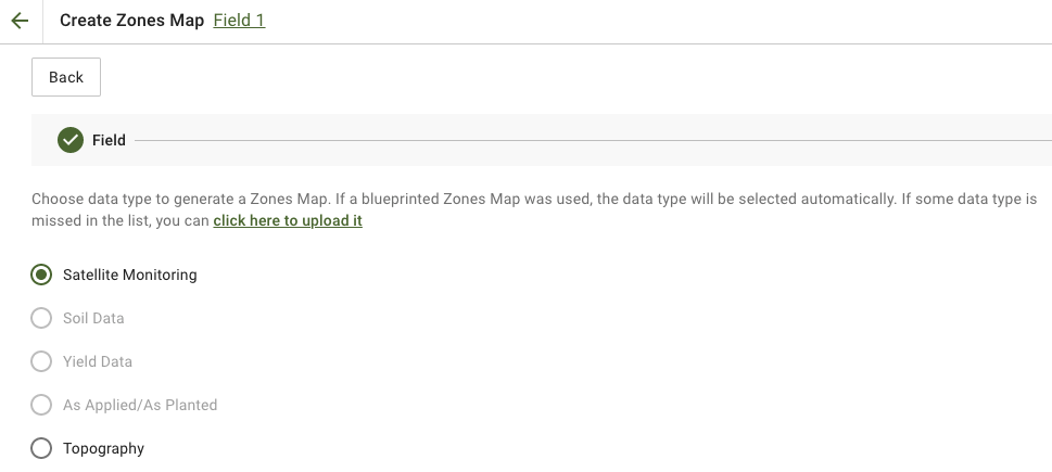
2. Válasszon **Műholdas megfigyelés** adattípust a folytatáshoz.
3. A következő lépésben műholdfelvételt választhat. Szűrhet hónap, év, szolgáltató vagy NDVI alapján, és válthat a különböző képtípusok, például az NIR és az EVI2 között. A **Az alábbiakban röviden bemutatjuk az indexek típusait.** hivatkozás ismerteti az elérhető indexeket. Ha módosítani szeretné az indexet, kattintson a(z) melletti nyílra: **EVI2**. Ezután kattintson a(z) **Tovább**.
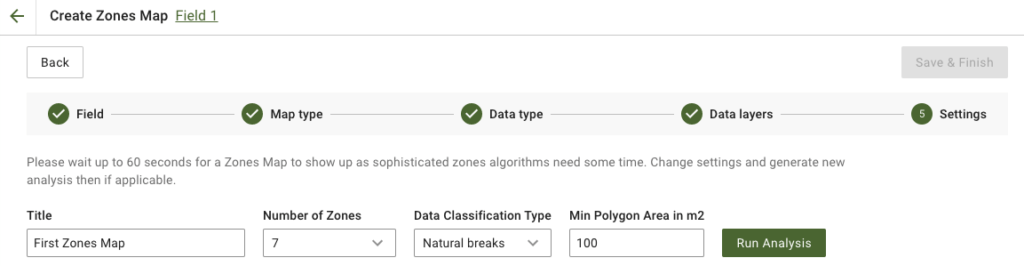
4. A következő lépésben módosíthatja a címet és a zónák számát, [kiválaszthatja az adatbesorolás típusát](https://docs.geopard.tech/geopard-tutorials/hu/termektura-webalkalmazas/zones-maps-and-analytics/using-data-classification.md), valamint meghatározhatja a minimális poligonterületet négyzetméterben. Kattintson a **Elemzés futtatása** gombra a folytatáshoz.
Az elemzés akár 60 másodpercig is tarthat, a megadott paraméterektől függően.
5. Ha elkészült, kattintson a **Mentés és befejezés**.
A mentés után a következő üzenet jelenik meg:
Készíthet egy újabb zónatérképet, hozzárendelhet dózisokat, vagy megnyithatja az imént létrehozott zónatérképet. Megnyitás után hasonló nézet jelenik meg.
---
# Agent Instructions
This documentation is published with GitBook. GitBook is the documentation platform designed so that both humans and AI agents can read, navigate, and reason over technical content effectively. Learn more at gitbook.com.
## Querying This Documentation
If you need additional information that is not directly available in this page, you can query the documentation by asking a question.
Perform an HTTP GET request on the following URL with the `ask` and `goal` query parameters:
```
GET https://docs.geopard.tech/geopard-tutorials/hu/termektura-webalkalmazas/zones-maps-and-analytics/create-a-zones-map-using-satellite-imagery.md?ask=&goal=
```
`ask` is the immediate question: it should be specific, self-contained, and written in natural language.
`goal` is what the user is ultimately trying to achieve, the reason they need the answer. Sharing it helps GitBook give you a better, more relevant answer. A goal is most helpful when it describes the outcome the user wants rather than restating the question. For example, with `ask=how do I create an API token`, a goal like `automate deployments from our CI pipeline` lets GitBook tailor the answer to that use case.
The response will contain a direct answer to the question and relevant excerpts and sources from the documentation.
Use this mechanism when the answer is not explicitly present in the current page, you need clarification or additional context, or you want to retrieve related documentation sections.