> For the complete documentation index, see [llms.txt](https://docs.geopard.tech/geopard-tutorials/llms.txt). Markdown versions of documentation pages are available by appending `.md` to page URLs; this page is available as [Markdown](https://docs.geopard.tech/geopard-tutorials/fin/tuote-esittely-verkkosovellus/vyohykekartat-ja-analytiikka/luo-vyohykekartta-satelliittikuvien-avulla.md).
# Luo vyöhykekartta satelliittikuvien avulla
Rakenna hallintavyöhykkeet satelliittikuvien pohjalta kohdentamaan vaihtelua ja ohjaamaan muuttuvan määrän päätöksiä.
1. Valitse lohko luettelosta ja napsauta **Luo vyöhykekartta** painiketta, valitse **Yksikerroksinen**, ja napsauta sitten **Seuraava**.
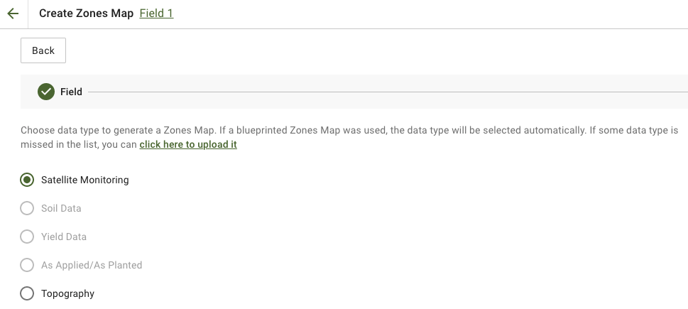
2. Valitse **Satelliittiseuranta** tietotyyppiä jatkaaksesi.
3. Seuraavassa vaiheessa voit valita satelliittikuvan. Voit suodattaa kuukauden, vuoden, tuottajan tai NDVI:n mukaan sekä vaihtaa kuvanäkymien, kuten NIR:n ja EVI2:n, välillä. **Tässä on lyhyt kuvaus indeksityypeistä** linkki selittää käytettävissä olevat indeksit. Jos sinun täytyy vaihtaa indeksiä, napsauta nuolta kohteen **EVI2**. Sitten napsauta **Seuraava**.
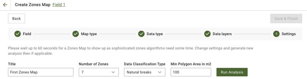
4. Seuraavassa vaiheessa voit muokata otsikkoa, muuttaa vyöhykkeiden määrää, [valita aineistoluokitustyypin](/geopard-tutorials/fin/tuote-esittely-verkkosovellus/vyohykekartat-ja-analytiikka/tietojen-luokittelu.md), ja määrittää vähimmäispolygoni-alan neliömetreinä. Napsauta **Suorita analyysi** jatkaaksesi.
Analyysi voi kestää enintään 60 sekuntia määrittämistäsi parametreista riippuen.
5. Kun se on valmis, napsauta **Tallenna ja viimeistele**.
Kun se on tallennettu, näet seuraavan viestin:
Voit luoda toisen vyöhykekartan, määrittää ajotasoja tai avata juuri luomasi vyöhykekartan. Jos avaat sen, näet samanlaisen näkymän.
---
# Agent Instructions
This documentation is published with GitBook. GitBook is the documentation platform designed so that both humans and AI agents can read, navigate, and reason over technical content effectively. Learn more at gitbook.com.
## Querying This Documentation
If you need additional information that is not directly available in this page, you can query the documentation by asking a question.
Perform an HTTP GET request on the following URL with the `ask` and `goal` query parameters:
```
GET https://docs.geopard.tech/geopard-tutorials/fin/tuote-esittely-verkkosovellus/vyohykekartat-ja-analytiikka/luo-vyohykekartta-satelliittikuvien-avulla.md?ask=&goal=
```
`ask` is the immediate question: it should be specific, self-contained, and written in natural language.
`goal` is what the user is ultimately trying to achieve, the reason they need the answer. Sharing it helps GitBook give you a better, more relevant answer. A goal is most helpful when it describes the outcome the user wants rather than restating the question. For example, with `ask=how do I create an API token`, a goal like `automate deployments from our CI pipeline` lets GitBook tailor the answer to that use case.
The response will contain a direct answer to the question and relevant excerpts and sources from the documentation.
Use this mechanism when the answer is not explicitly present in the current page, you need clarification or additional context, or you want to retrieve related documentation sections.