> For the complete documentation index, see [llms.txt](https://docs.geopard.tech/geopard-tutorials/llms.txt). Markdown versions of documentation pages are available by appending `.md` to page URLs; this page is available as [Markdown](https://docs.geopard.tech/geopard-tutorials/fin/tuote-esittely-verkkosovellus/zones-maps-and-analytics.md).

# Vyöhykekartat ja analytiikka

Luo hallintavyöhykkeitä kuvien, satotietojen, maaperän, topografian ja yhtälöiden avulla parempia vaihteluvälipäätöksiä varten.

Käyttäjät voivat aloittaa vyöhykekartan luomisen kahdella tavalla. Ensimmäinen tapa on käyttää **Luo vyöhykekartta** -painiketta, jonka avulla käyttäjä voi valita, miten vyöhykekartta luodaan. Toinen tapa on **kloonata** olemassa oleva vyöhykekartta, jolloin parametreja ja muutoksia voi kokeilla muuttamatta vyöhykekartan luontitavan valintaa.

{% hint style="info" %}
Katso interaktiivinen hallintavyöhykkeiden ja VRA-karttojen sivu osoitteessa geopard.tech: [Hallintavyöhykkeet ja VRA-kartat](https://geopard.tech/management-zones-vra-maps/)
{% endhint %}

## Näytä vyöhykekartta

Seuraavilla näytöillä esitellään lyhyesti käytettävissä olevat ohjaimet, jotta näet, mitä tietoja näytön eri osissa on.

<figure><img src="https://49925783-files.gitbook.io/~/files/v0/b/gitbook-x-prod.appspot.com/o/spaces%2FYICBELdyAXXebKAzfLOR%2Fuploads%2Fxq40oN6Fp3OTLVB3vxAn%2Fimage.png?alt=media&amp;token=05cbc074-02d2-4219-bdc4-0554998436d9" alt=""><figcaption><p>Vyöhykekartan ohjaimet</p></figcaption></figure>

<figure><img src="https://49925783-files.gitbook.io/~/files/v0/b/gitbook-x-prod.appspot.com/o/spaces%2FYICBELdyAXXebKAzfLOR%2Fuploads%2F6qMbc4RgZYE5WC4KKuAJ%2Fimage.png?alt=media&amp;token=e2bda194-60c7-4e34-baa2-434bc94b3ee9" alt=""><figcaption><p>Vyöhykekartan ohjaimet</p></figcaption></figure>

## Luo vyöhykekartta -painikkeella

Luo pellollesi vyöhykekartta avaamalla pelto peltoluettelosta ja napsauttamalla sitten **Luo vyöhykekartta** -painiketta:

<figure><img src="https://lh5.googleusercontent.com/7IapbLUHoeZR3k-q_yNsfktTcTTbd7sJbLdflCuRCauAHm88Ckro45eeRObbCDU2SvcOj3yzBpRRUHdqYaME8cYYAodwpLQVohl3HloDgzdG4VhIEdD9f6M9gdV4uh2Ogj9ioGG1" alt="This image has an empty alt attribute; its file name is 24-1.png" width="563"><figcaption><p>Aloita vyöhykekartan luonti</p></figcaption></figure>

Siirryt Vyöhykkeiden luontityökaluun, jossa sinun on valittava luotavan vyöhykekartan tyyppi.

<figure><img src="https://lh6.googleusercontent.com/M5yZVRKrPxTeEzqGoNxeTo_pIY8lZhPmRK_CfkaarMSTtUzaTmih2fE_JCN8Xazjj3KeSTeJ7LatqzbInUtWDydLFnyL3Lv4dF65TGC0AS-ivaAleEszHnz8-CjotlhMZAJl4fz9" alt="This image has an empty alt attribute; its file name is image-1.png" width="563"><figcaption><p>Käytettävissä olevat vyöhykekartan luontitavat</p></figcaption></figure>

Eri tyyppien käytöstä kerrotaan tarkemmin seuraavissa osioissa:

1. [Vyöhykekartan luominen satelliittikuvien avulla](https://docs.geopard.tech/geopard-tutorials/fin/tuote-esittely-verkkosovellus/zones-maps-and-analytics/create-a-zones-map-using-satellite-imagery.md)
2. [Vyöhykekartan luominen maaperä-, satotieto- tai levitystiedon avulla](https://docs.geopard.tech/geopard-tutorials/fin/tuote-esittely-verkkosovellus/zones-maps-and-analytics/create-a-zones-map-using-soil-yield-or-as-applied-data.md)
3. [Vyöhykekartan luominen topografiatietojen avulla](https://docs.geopard.tech/geopard-tutorials/fin/tuote-esittely-verkkosovellus/zones-maps-and-analytics/create-a-zones-map-using-topography.md)
4. [Vyöhykekartan luominen mallipohjan avulla](https://docs.geopard.tech/geopard-tutorials/fin/tuote-esittely-verkkosovellus/zones-maps-and-analytics/create-a-zones-map-using-a-template.md)
5. [Tietojen luokittelun käyttö](https://docs.geopard.tech/geopard-tutorials/fin/tuote-esittely-verkkosovellus/zones-maps-and-analytics/using-data-classification.md)
6. [VRA:n määrittäminen](https://docs.geopard.tech/geopard-tutorials/fin/tuote-esittely-verkkosovellus/zones-maps-and-analytics/assign-variable-rates-in-zones-ag-input-rates-distribution-tool.md)
7. [Vyöhykekartan muokkaaminen: yhdistäminen ja jakaminen](https://docs.geopard.tech/geopard-tutorials/fin/tuote-esittely-verkkosovellus/zones-maps-and-analytics/edit-zones-map-merge-and-split.md)
8. [Usean vuoden vyöhykkeet](https://docs.geopard.tech/geopard-tutorials/fin/tuote-esittely-verkkosovellus/zones-maps-and-analytics/multi-year-zones.md)
9. [Monikerrosanalyysi](https://docs.geopard.tech/geopard-tutorials/fin/tuote-esittely-verkkosovellus/zones-maps-and-analytics/multi-layer-analytics.md)

## Olemassa olevan vyöhykekartan kloonaaminen

Voit kloonata olemassa olevan vyöhykekartan napsauttamalla <img src="https://49925783-files.gitbook.io/~/files/v0/b/gitbook-x-prod.appspot.com/o/spaces%2FYICBELdyAXXebKAzfLOR%2Fuploads%2F3vG8QyQkqzewbqEGatt6%2Fimage.png?alt=media&amp;token=740d067b-4388-47b8-b28f-b308efc70c00" alt="" data-size="line"> -painiketta ja valitsemalla **Kloonaa** -vaihtoehdon. Tämän jälkeen siirryt vyöhykekartan luontiin, jossa aiemmin käytetyt asetukset on valmiiksi ladattu. Näitä ovat esimerkiksi tietotasot, vyöhykkeiden määrä ja muut asetukset.
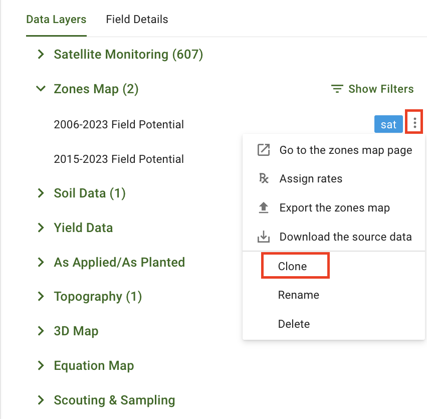
<figure><img src="https://49925783-files.gitbook.io/~/files/v0/b/gitbook-x-prod.appspot.com/o/spaces%2FYICBELdyAXXebKAzfLOR%2Fuploads%2FLZZvkkL1VF7uAFBMBbuR%2Fimage.png?alt=media&amp;token=cf13456d-7817-4ce8-b861-c7d08286e983" alt="" width="563"><figcaption><p>Aloita olemassa olevan vyöhykekartan kloonaaminen</p></figcaption></figure>


---

# Agent Instructions
This documentation is published with GitBook. GitBook is the documentation platform designed so that both humans and AI agents can read, navigate, and reason over technical content effectively. Learn more at gitbook.com.

## Querying This Documentation
If you need additional information that is not directly available in this page, you can query the documentation by asking a question.

Perform an HTTP GET request on the following URL with the `ask` and `goal` query parameters:

```
GET https://docs.geopard.tech/geopard-tutorials/fin/tuote-esittely-verkkosovellus/zones-maps-and-analytics.md?ask=<question>&goal=<user_goal>
```

`ask` is the immediate question: it should be specific, self-contained, and written in natural language.
`goal` is what the user is ultimately trying to achieve, the reason they need the answer. Sharing it helps GitBook give you a better, more relevant answer. A goal is most helpful when it describes the outcome the user wants rather than restating the question. For example, with `ask=how do I create an API token`, a goal like `automate deployments from our CI pipeline` lets GitBook tailor the answer to that use case.

The response will contain a direct answer to the question and relevant excerpts and sources from the documentation.

Use this mechanism when the answer is not explicitly present in the current page, you need clarification or additional context, or you want to retrieve related documentation sections.
