> For the complete documentation index, see [llms.txt](https://docs.geopard.tech/geopard-tutorials/llms.txt). Markdown versions of documentation pages are available by appending `.md` to page URLs; this page is available as [Markdown](https://docs.geopard.tech/geopard-tutorials/fin/tuote-esittely-verkkosovellus/john-deere-operations-center-integration.md).

# John Deere Operations Center -integraatio

Yhdistä GeoPard Operations Centeriin: tuo lohkorajat, satotiedot sekä kylvön ja levityksen toteumatiedot ja lähetä lannoituskartat takaisin tiedostoina tai Work Plan -tehtäväsuunnitelmina.

GeoPard muodostaa kaksisuuntaisen yhteyden John Deere Operations Centeriin. Se tuo järjestelmään lohkorajat, satotiedot, kylvö- ja levitystiedot sekä muokkaustiedot ja lähettää takaisin levityskartat (tiedostoina tai Work Plan -työsuunnitelmina), lohkorajat, karttatasot ja levitystoimenpiteet. Yhdistät palvelut John Deere -kirjautumistiedoillasi ja valitset, minkä organisaatioiden tietoja GeoPard saa lukea. Konsultit voivat yhdistää useiden viljelijöiden organisaatiot yhteen GeoPard-tiliin.

{% hint style="success" %}
Rekisteröidy John Deere -tililläsi ja tarkastele lohkojasi GeoPardissa: [Aloita maksutta](https://app.geopard.tech/auth/sign-up?utm_source=docs\&utm_medium=cta\&utm_campaign=john-deere-operations-center-integration)
{% endhint %}

Jos sinulla on John Deere Operations Center -tili, voit integroida sen helposti GeoPardiin ja ottaa käyttöön lisäominaisuuksia ja -etuja. Aloita siirtymällä osoitteeseen <mark style="color:sininen;">app.geopard.tech</mark> ja rekisteröidy maksuttomaan kokeilujaksoon, johon sisältyy 100 hehtaarin (250 eekkerin) kattavuus.

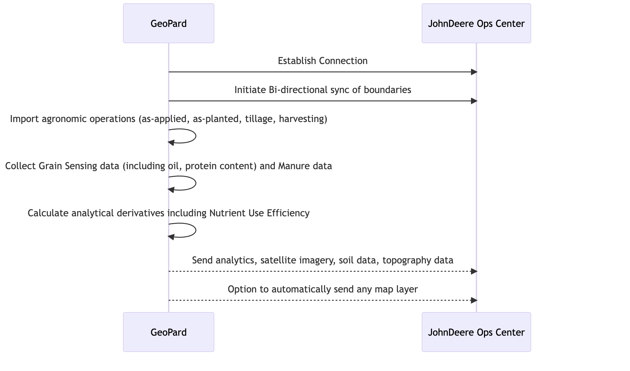
<figure><img src="https://49925783-files.gitbook.io/~/files/v0/b/gitbook-x-prod.appspot.com/o/spaces%2FYICBELdyAXXebKAzfLOR%2Fuploads%2FeuyIJg5ilPzLEn0FQgDq%2FGeoPard%20-%20Ops%20Center%20Connected.png?alt=media&amp;token=1b363e2d-5daf-4c03-84fc-8d110161efdd" alt=""><figcaption><p>GeoPard tarjoaa MyJohnDeere Operation Centerin käyttäjille (viljelijöille ja jälleenmyyjille) edistyksellistä automaattista analytiikkaa</p></figcaption></figure>

Kun olet luonut tilin, voit helposti yhdistää MyJohnDeere-organisaatiosi ja synkronoida tärkeät tiedot, kuten lohkotiedot, sadonkorjuutiedot sekä levitys-, kylvö- ja muokkaustiedot. Voit lisäksi luoda levityskarttoja ja lähettää ilmakuvat, topografiatiedot ja maaperätiedot suoraan John Deere Operations Centeriin, mikä tehostaa viljelytoimiasi entisestään.

Jos käytät mieluummin osoitetta [app.geopard.tech](https://app.geopard.tech), voit silti hyödyntää samaa John Deere Operations Center -integraatiota. Huomaa kuitenkin, ettei maksuton kokeilujakso ole tällöin saatavilla.

Integroimalla GeoPardin John Deere Operations Center -tiliisi voit hyödyntää molempien alustojen tarjoamia mahdollisuuksia, tehostaa viljelytoimiasi ja tehdä perustellumpia päätöksiä kattavien ja ajantasaisten tietojen pohjalta.

### Synkronoinnin ajoitus

Synkronointi käynnistyy tapahtumien perusteella, eikä sitä tehdä ajastetusti. John Deere ilmoittaa GeoPardille, kun uusi toimenpide tulee saataville.

GeoPard pyytää arkiston. John Deere luo sen. GeoPard tuo sen järjestelmään, kun se on valmis. GeoPard tarkistaa arkiston valmiuden 20 minuutin välein.

GeoPard yrittää uudelleen enintään 24 tunnin ajan. Tänä aikana se voi tarkistaa arkiston valmiuden enintään 72 kertaa.

| Arkiston tila                                                        | Aika GeoPardiin siirtymiseen |
| -------------------------------------------------------------------- | ---------------------------- |
| Pieni arkisto                                                        | 15–50 minuuttia              |
| Suuri arkisto                                                        | Enintään 2 tuntia            |
| John Deeren palvelukuormitus kasvukauden huippuaikoina (harvinaista) | Enintään puoli päivää        |

Odotusaika kuluu siihen, että John Deere luo arkiston. GeoPard ei suorita päivittäistä eräajoa. Määrityksiä ei tarvita.

Voit tuoda tiedot uudelleen manuaalisesti milloin tahansa. Jos toimenpide puuttuu vielä 24 tunnin kuluttua, varmista, että se on suljettu ja ladattu Operations Centeriin. Muussa tapauksessa ota yhteyttä tukeen.

### Integraation kaaviokuva

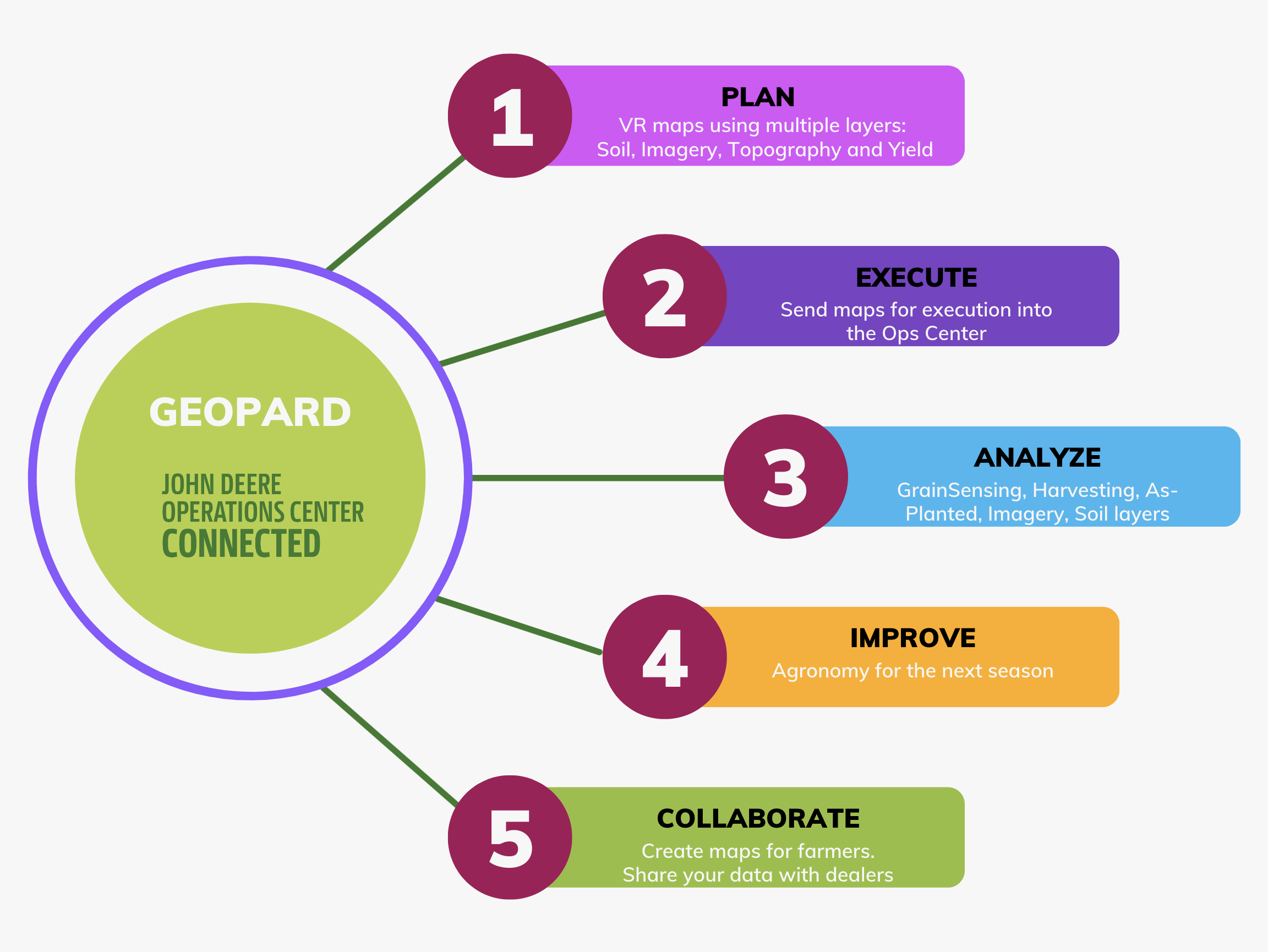
<figure><img src="https://49925783-files.gitbook.io/~/files/v0/b/gitbook-x-prod.appspot.com/o/spaces%2FYICBELdyAXXebKAzfLOR%2Fuploads%2FFZhSfpU72m5pJpKW4SE9%2FScreenshot%202023-06-27%20at%2016.18.10.png?alt=media&amp;token=73e2114e-6453-4689-b230-fcf9094ac25b" alt=""><figcaption><p>Sekvenssikaavio, joka havainnollistaa GeoPardin ja JohnDeere Ops Centerin välistä integraatioprosessia</p></figcaption></figure>

### Automaattisen kaksisuuntaisen integraation tuetut toiminnot

1. [Yhdistä MyJohnDeere Operations Centeriin](https://docs.geopard.tech/geopard-tutorials/fin/tuote-esittely-verkkosovellus/john-deere-operations-center-integration/2.-connect-to-john-deere-operations-center.md) GeoPardilla
2. [Yhdistä MyJohnDeere-organisaatioihin](https://docs.geopard.tech/geopard-tutorials/fin/tuote-esittely-verkkosovellus/john-deere-operations-center-integration/3.-connect-to-john-deere-organizations.md)
3. [Tuo tietoja MyJohnDeere Operations Centeristä ](https://docs.geopard.tech/geopard-tutorials/fin/tuote-esittely-verkkosovellus/john-deere-operations-center-integration/4.-import-into-geopard-from-john-deere-operations-center.md)GeoPardiin
   * Lohkorajat
   * Toimenpidekartat
     * *Kylvö (kylvötiedot)*
     * *Levitystiedot: levitys* lannoitteiden, kasvinsuojeluaineiden ja kasvunsääteiden levityksestä
     * *GrainSensing-tiedot*, mukaan lukien proteiini- ja öljypitoisuus, jotka saadaan laitteesta [John Deere HarvestLab™ 3000](https://www.deere.com/en/technology-products/precision-ag-technology/data-management/harvest-lab-constituent-sensing/)
     * *Lantatiedot*
     * *Sadonkorjuu*
     * *Maanmuokkaus*
     * *Koko historiatietojen arkisto*
4. Vie tietoja GeoPardista John Deere Operations Centeriin
   * [Lohkorajat](https://docs.geopard.tech/geopard-tutorials/fin/tuote-esittely-verkkosovellus/john-deere-operations-center-integration/7.-export-field-boundaries-to-john-deere-operations-center.md)
   * [Synkronoi lohko John Deere Operations Centerin kanssa](https://docs.geopard.tech/geopard-tutorials/fin/tuote-esittely-verkkosovellus/john-deere-operations-center-integration/11.-synchronize-a-field-with-john-deere-operations-center.md)
   * [VRA-kartat työsuunnitelmina](https://docs.geopard.tech/geopard-tutorials/fin/tuote-esittely-verkkosovellus/john-deere-operations-center-integration/8.-export-rx-maps-to-john-deere-operations-center-as-work-plans.md) varten
     * Kylvöreseptit
     * Lannoitusreseptit (tulossa)
     * Kasvinsuojelu (tulossa)
     * Kasvunsääteet (tulossa)
   * [VRA-kartat tiedostoina](https://docs.geopard.tech/geopard-tutorials/fin/tuote-esittely-verkkosovellus/john-deere-operations-center-integration/6.-export-rx-maps-to-john-deere-operations-center-as-files.md) kohteelle
     * Kylvöreseptit
     * Lannoitusreseptit
     * Kasvinsuojelu
     * Kasvunsääteet
   * Hallintavyöhykkeet (esim. lohkon potentiaalikartat)
   * LIDAR- tai GPS-aineistoon perustuvat topografiakartat
   * Näytteenoton tai skannauksen perusteella laaditut maaperäkartat ([Sähkönjohtavuus](https://geopard.tech/blog/k9s011204i-high-density-sensor-data/), Veris/EM38/DualEM, [SoilOptix](https://geopard.tech/blog/brrck2udr1-soiloptix-data-analysis-in-precision-agr/), [TopSoilMapper](https://geopard.tech/blog/agte3p8ec1-analyze-geoprospectors-topsoilmapper-dat/)).
   * Landsat-, Sentinel- ja Planet-palveluntarjoajien satelliittikuvat, joissa näkyvät RBG, NIR ja kontrasti-/korostettu kasvillisuus
   * Yhtälöihin perustuva analytiikka; [lisätietoja](https://geopard.tech/blog/equation-based-analytics-precision/) NUE:sta, ROI-kartoista sekä tavoitteen ja toteutuneen levityksen vertailulaskennasta
5. [Automaattinen tietojen synkronointi](https://docs.geopard.tech/geopard-tutorials/fin/tuote-esittely-verkkosovellus/john-deere-operations-center-integration/5.-configure-automated-data-sync.md)\
   Seuraavat toiminnot voidaan ottaa käyttöön erikseen GeoPardin John Deere -integrointisivulla.
   * GeoPard seuraa jatkuvasti uusia toimintakarttoja: se lataa ne automaattisesti ja liittää ne olemassa oleviin lohkorajoihin.\
     Seurattaviin toimintakarttoihin kuuluvat *Kylvö*, *Levitys*, *Sadonkorjuu*, ja *Muokkaus*.
   * GeoPard siirtää käyttäjän tekemät muutokset *lohkorajoihin* takaisin Operations Centeriin.
   * GeoPard lähettää *topografiakartat*, *maaperäkartat* näytteistä ja skannereista, *hallintavyöhykkeet*, ja *yhtälökartat* visuaalisina karttatasoina John Deere Operations Centeriin.
6. Tietoyhteys Climate FieldView’hun\
   Se mahdollistaa lähes reaaliaikaisen tiedonsiirron GeoPardin ja FieldView’n välillä John Deere Operations Centerin kautta. GeoPard kerää FieldView’hun tallennetut toimenpiteet historiallisine arkistoineen ja lähettää lohkorajat sekä VRA-kartat.

{% hint style="success" %}
Rekisteröidy John Deere -tililläsi ja tarkastele lohkojasi GeoPardissa: [Aloita maksutta](https://app.geopard.tech/auth/sign-up?utm_source=docs\&utm_medium=cta\&utm_campaign=john-deere-operations-center-integration)
{% endhint %}


---

# Agent Instructions
This documentation is published with GitBook. GitBook is the documentation platform designed so that both humans and AI agents can read, navigate, and reason over technical content effectively. Learn more at gitbook.com.

## Querying This Documentation
If you need additional information that is not directly available in this page, you can query the documentation by asking a question.

Perform an HTTP GET request on the following URL with the `ask` and `goal` query parameters:

```
GET https://docs.geopard.tech/geopard-tutorials/fin/tuote-esittely-verkkosovellus/john-deere-operations-center-integration.md?ask=<question>&goal=<user_goal>
```

`ask` is the immediate question: it should be specific, self-contained, and written in natural language.
`goal` is what the user is ultimately trying to achieve, the reason they need the answer. Sharing it helps GitBook give you a better, more relevant answer. A goal is most helpful when it describes the outcome the user wants rather than restating the question. For example, with `ask=how do I create an API token`, a goal like `automate deployments from our CI pipeline` lets GitBook tailor the answer to that use case.

The response will contain a direct answer to the question and relevant excerpts and sources from the documentation.

Use this mechanism when the answer is not explicitly present in the current page, you need clarification or additional context, or you want to retrieve related documentation sections.