> For the complete documentation index, see [llms.txt](https://docs.geopard.tech/geopard-tutorials/llms.txt). Markdown versions of documentation pages are available by appending `.md` to page URLs; this page is available as [Markdown](https://docs.geopard.tech/geopard-tutorials/esp/consejos-rapidos-de-sig/qgis-dividir-shapefiles-multiparcela.md).

# QGIS: Dividir shapefiles multiparcela

Si un archivo shapefile contiene varios polígonos de parcelas, sepáralo antes de importarlo. GeoPard importa un límite de parcela por shapefile. Este flujo de trabajo en QGIS te ayuda a preparar archivos limpios más rápido y evitar problemas de importación.

### Antes de empezar

* Asegúrate de que la capa tenga un nombre o ID de parcela único.
* Crea con antelación una carpeta de salida vacía.
* Elimina `/`, `\`, y caracteres especiales similares de los nombres de parcela.

### Dividir un shapefile con varias parcelas en QGIS

#### 1. Abre el shapefile en QGIS

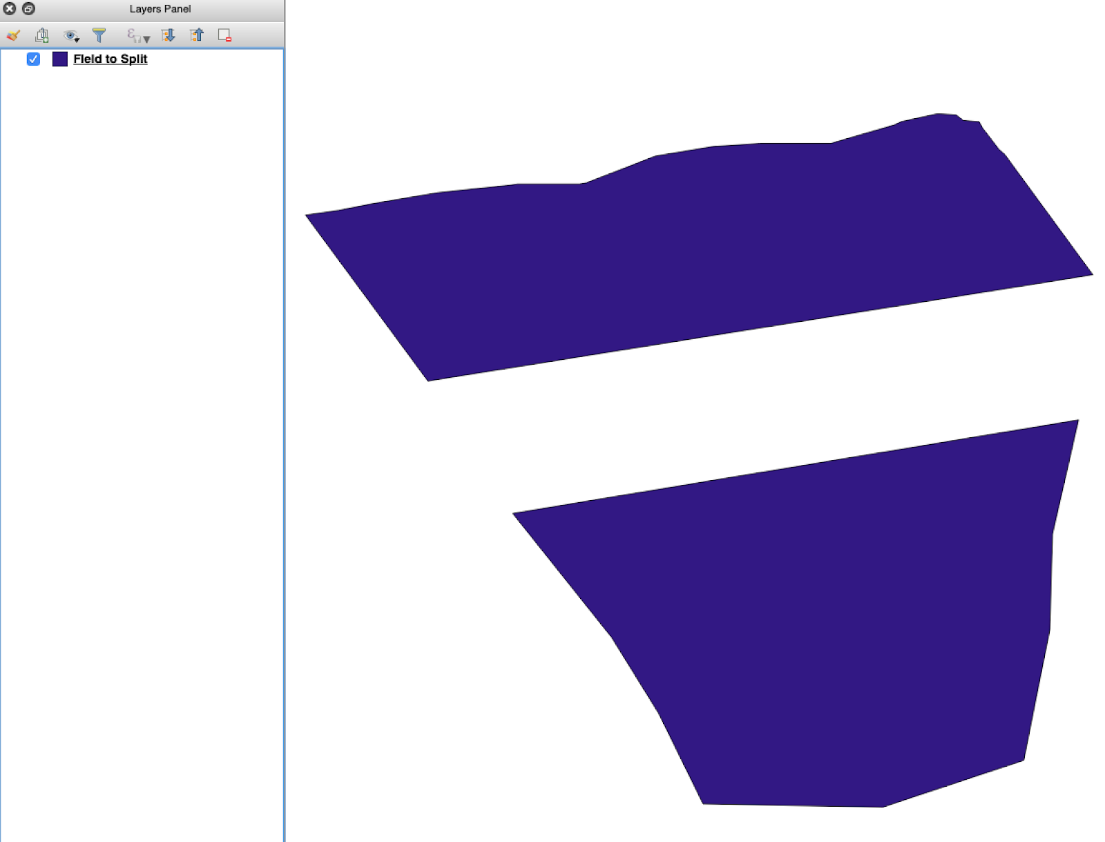
Abre el shapefile de origen en QGIS. Confirma que contiene varios polígonos de parcelas.

<figure><img src="https://lh5.googleusercontent.com/G8ooE_FarMCXvt6CjpvfwgRIiIwLVcSki84FFUiBelII7dZVLJHPN2K_Dj4As-VZNXYsut1q2JGtYEir3GCVfWqwKe4UAI9r9OcIM87jOkDRfiGes_wmD6zTmUyZpUZXgkQBUaW8RCsdaUKY18kaVQ" alt=""><figcaption><p>Capa inicial de límites de parcela con varios polígonos.</p></figcaption></figure>

#### 2. Abre la herramienta de división

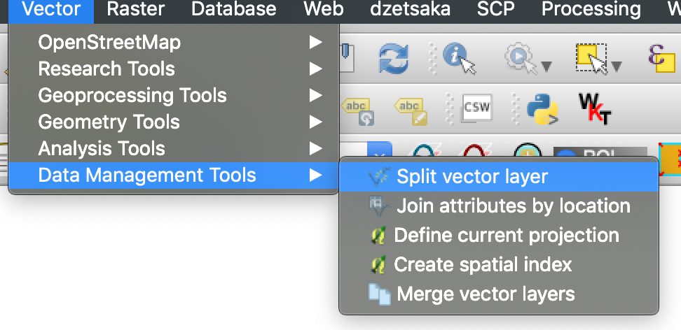
Abre las opciones de la capa y elige **Dividir capa vectorial**.

<figure><img src="https://lh4.googleusercontent.com/g5B3A43gGlRbUBv2hkAt8xVT7UXzLvj06KB99R471uQQAIZLdoHFPmopQfz9ntwflEEN70DDUuMp7LQGqPocfzkBWbVc27Fm3pPCu2kWhbfnaG54TKGKmj4gKJw7sA10NKJf6ezJ62JVLtMlpSAl1Q" alt=""><figcaption><p>Abre el flujo de trabajo de división.</p></figcaption></figure>

#### 3. Elige la capa, el atributo y la carpeta de salida

Configura:

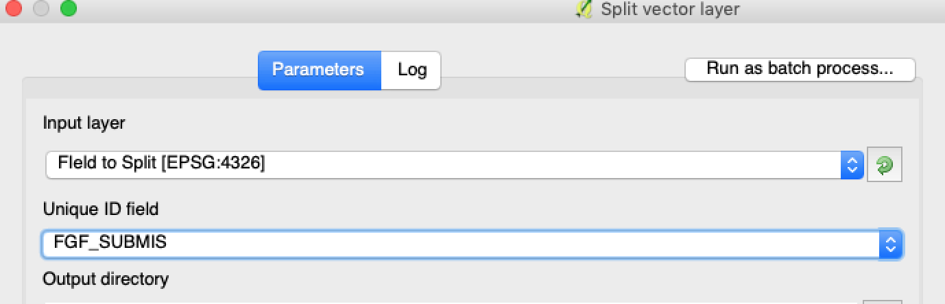
1. La capa a dividir.
2. Un atributo único para cada parcela.
3. El directorio de salida.

<figure><img src="https://lh3.googleusercontent.com/oWwaxwcCPhOp6kIlpDM4z0CK_J_Q6QGCoIdXhr-vMrpQrf_HOLT5ZfHYExEk7J0QIYdPKunOdhe14S9Ay_-FtwGnTnq19GdtnWC4cUcEhEOXIGj7vZdZPsCovszX0sVdz1bF-yraci-5g09ZNJRocw" alt=""><figcaption><p>Selecciona la capa de origen y el atributo de división.</p></figcaption></figure>

#### 4. Configura el formato de salida

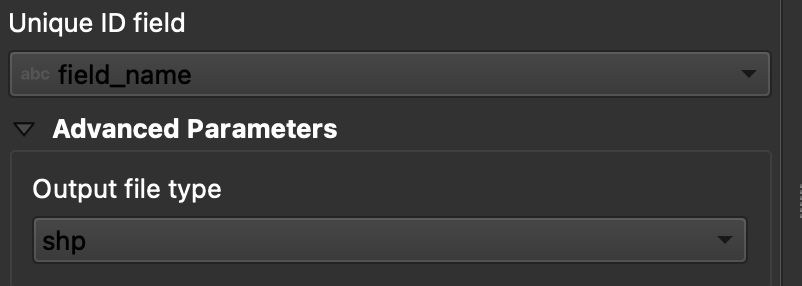
Elige **ESRI Shapefile** como formato de salida.

<figure><img src="https://lh6.googleusercontent.com/tDOJ7vPBHqCy8peu5Xb97FkYz43HZXnniWwYj6-UXcaMyJaEvuWqx6ew40n9OvXM9OGrPGof0rWasEcgQFjh9SEakNXKW4K4n3Ei56B6jwttr_NW30naaD4OYNJERbQeqeX7bE4JJNd_HwYlgdKIqg" alt=""><figcaption><p>Configura la carpeta de salida y el formato shapefile.</p></figcaption></figure>

#### 5. Ejecuta la división

Haz clic en **Ejecutar**. QGIS crea un archivo por polígono. Cada polígono se convierte en un shapefile de límite de parcela independiente.

#### 6. Convierte `.gpkg` a archivos `.shp` si es necesario

Algunas configuraciones de QGIS crean primero archivos `.gpkg` . Si eso ocurre, abre cada archivo y guárdalo de nuevo como **ESRI Shapefile**.

1. Haz clic con el botón derecho en la capa.
2. Selecciona **Exportar** → **Guardar entidades como**.
3. Elige **ESRI Shapefile**.
4. Configura el nombre del archivo y la ubicación.
5. Elimina los atributos que no sean necesarios si hace falta.

### Resultado

Ahora tienes un shapefile por parcela. Cada archivo está listo para cargar los límites de parcela en GeoPard. Esto ahorra tiempo de configuración y reduce retrabajos de importación evitables.

### Guías relacionadas de QGIS

* [QGIS: Convertir CSV a SHP](/geopard-tutorials/esp/consejos-rapidos-de-sig/qgis-convertir-csv-a-shp.md)
* [QGIS: Reproyectar shapefile](/geopard-tutorials/esp/consejos-rapidos-de-sig/qgis-reproyectar-shapefile.md)


---

# Agent Instructions
This documentation is published with GitBook. GitBook is the documentation platform designed so that both humans and AI agents can read, navigate, and reason over technical content effectively. Learn more at gitbook.com.

## Querying This Documentation
If you need additional information that is not directly available in this page, you can query the documentation dynamically by asking a question.

Perform an HTTP GET request on the current page URL with the `ask` query parameter, and the optional `goal` query parameter:

```
GET https://docs.geopard.tech/geopard-tutorials/esp/consejos-rapidos-de-sig/qgis-dividir-shapefiles-multiparcela.md?ask=<question>&goal=<endgoal>
```

`ask` is the immediate question: it should be specific, self-contained, and written in natural language.
`goal` is optional and describes the broader end goal you are ultimately trying to accomplish on behalf of the user. GitBook uses it to tailor the answer towards what is most useful for that goal.

The response will contain a direct answer to the question and relevant excerpts and sources from the documentation.

Use this mechanism when the answer is not explicitly present in the current page, you need clarification or additional context, or you want to retrieve related documentation sections.