> For the complete documentation index, see [llms.txt](https://docs.geopard.tech/geopard-tutorials/llms.txt). Markdown versions of documentation pages are available by appending `.md` to page URLs; this page is available as [Markdown](https://docs.geopard.tech/geopard-tutorials/dnk/produktguide-webapp/export-download/batch-export-of-boundaries-zones-and-scouting-pins.md).
# Batch-eksport af grænser, zoner og scouting-punkter
GeoPard lader dig eksportere datalag og VRA-kort i batches, med en grænse på 100 lag pr. download.
Flyt lagene ind i dit GIS, John Deere Operations Center eller en hvilken som helst maskinstyring med et par klik.
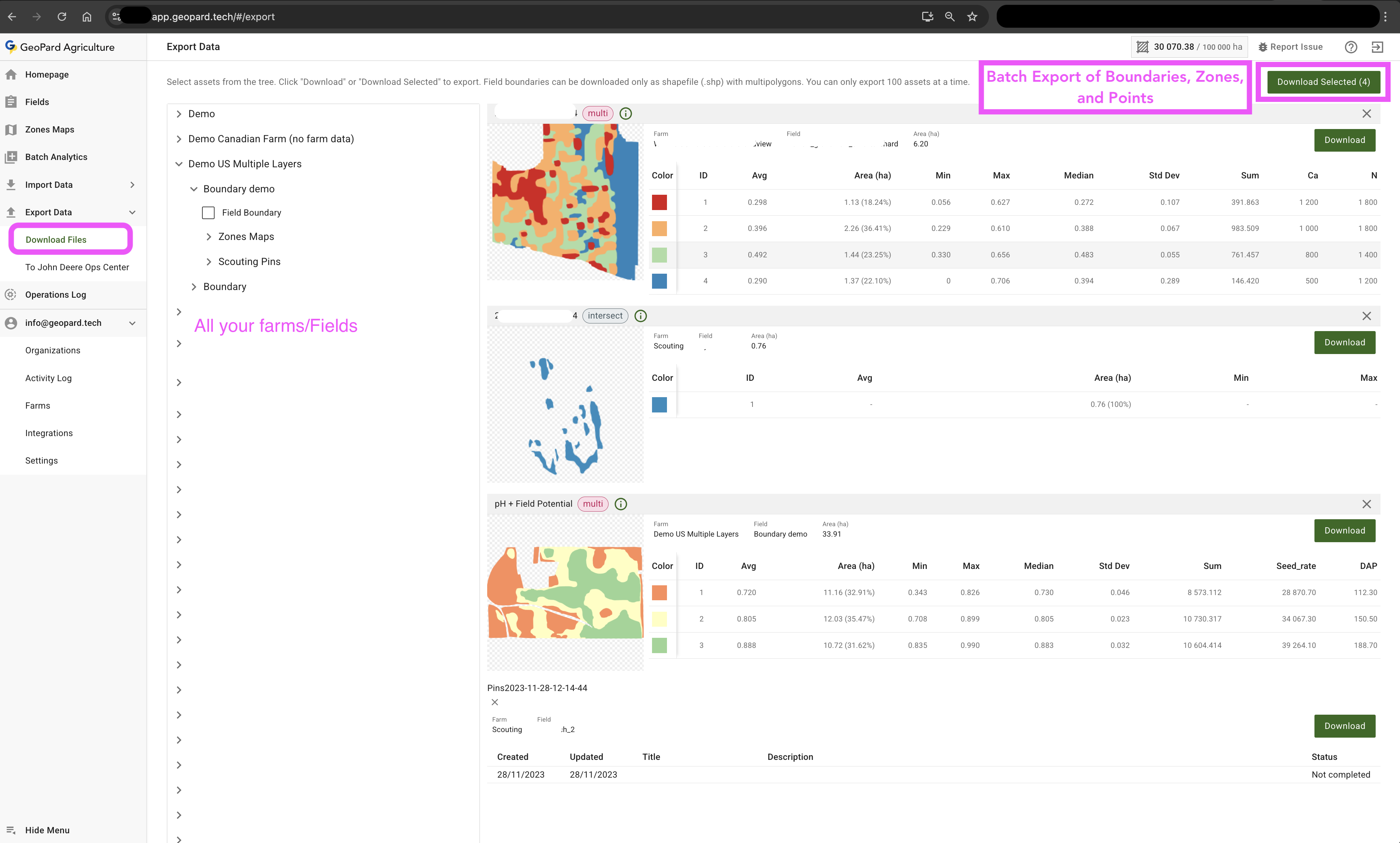
Masseeksport af markgrænser, zoner og scoutingmarkører
### Hurtig vej
* Log ind på [`app.geopard.tech`](https://app.geopard.tech/auth/sign-in) og gå til **Eksportér data**.
* Markér de lag, du har brug for – zoner, scoutingmarkører, markgrænser osv.
* Klik på **Download valgte**.
* Vælg eksporttypen i pop op-vinduet (se nedenfor), og tryk på **Eksportér**.
Eksportmuligheder
### Eksporttyper
| Mulighed | Det får du | Hvornår skal den bruges? |
| ---------------------------------------------- | ----------------------------------------------------------------------------- | -------------------------------------------------------------------------------------------------------------------------------------------------- |
| **Eksportér zoner til John Deere Ops Center** | ZIP-fil med en shapefile med multipolygoner | Direkte upload til John Deere Ops Center som Rx-filer |
| **Download Shapefile (.shp) – multipolygoner** | Én feature pr. klasse, velegnet til de fleste GIS-systemer og maskinstyringer | Klassisk VRA-arbejdsgang |
| **Download Shapefile (.shp) – polygoner** | Hver polygon som sin egen feature | Når du skal bruge rå geometri til redigering. Nogle terminaler har begrænsninger på antallet af polygoner, så multipolygoner er som regel bedre. |
| **Download ISOXML** | ISOXML-opgavefil | Tilgængelig, når kortet har sprøjte-, så- eller gødningsmængder med gyldige enheder. Forudsætning: Angiv enheder og operationstype ved oprettelse. |
| **Kun mængder** (afkrydsningsfelt) | Samme fil, men med kun mængdekolonnen | Til applikation med variabel tildeling, så risikoen for menneskelige fejl minimeres |
### Trin for trin
1. Åbn **Download filer** eller gå direkte til `/export`.
2. Fold bedrifter og marker ud, og markér op til **100** lag.
3. Der vises et forhåndsvisningskort for hvert lag, så du kan kontrollere dem.
4. Klik på **Download valgte** → vælg eksporttype → **Eksportér**.
5. GeoPard opretter en ZIP-fil. Hvert lag bliver til sit eget shapefile-sæt (`.shp`, `.shx`, `.dbf`, `.prj`, `.cpg`). Ingen GeoJSON- eller CSV-filer på nuværende tidspunkt.
6. Arkivet downloades automatisk til browserens standardmappe til downloads.
### Godt at vide
* Filnavne slutter med `_GP`, så du kan spore dem tilbage til GeoPard.
* Alle attributter bevares: zone-id, gennemsnitsværdi, areal, statistik, noter, fotos osv.
### Eksempel på downloadet arkiv
Downloadet arkiv på macOS. Du kan importere SHP-filen til en VRA-terminal eller et andet GIS-værktøj.
### Typiske arbejdsgange
| Formål | Hvad skal du vælge? | Resultat |
| ----------------------------------------------- | --------------------------------------------- | ----------------------------------------------------------------- |
| Udarbejd såningsplaner for foråret | Zonekort fra flere marker | ZIP-fil med shapefiler, klar til sammenlægning i terminalen |
| Del resultaterne fra markbesøget med en agronom | Alle markeringer fra markbesøget på bedriften | Shapefile, som hun kan åbne i QGIS eller uploade til GeoPard igen |
| Opret et rent GIS-grundlag | Markgrænser + vigtige zoner | Komplet pakke for hele bedriften til brug i alle GIS-værktøjer |
---
# Agent Instructions
This documentation is published with GitBook. GitBook is the documentation platform designed so that both humans and AI agents can read, navigate, and reason over technical content effectively. Learn more at gitbook.com.
## Querying This Documentation
If you need additional information that is not directly available in this page, you can query the documentation by asking a question.
Perform an HTTP GET request on the following URL with the `ask` and `goal` query parameters:
```
GET https://docs.geopard.tech/geopard-tutorials/dnk/produktguide-webapp/export-download/batch-export-of-boundaries-zones-and-scouting-pins.md?ask=&goal=
```
`ask` is the immediate question: it should be specific, self-contained, and written in natural language.
`goal` is what the user is ultimately trying to achieve, the reason they need the answer. Sharing it helps GitBook give you a better, more relevant answer. A goal is most helpful when it describes the outcome the user wants rather than restating the question. For example, with `ask=how do I create an API token`, a goal like `automate deployments from our CI pipeline` lets GitBook tailor the answer to that use case.
The response will contain a direct answer to the question and relevant excerpts and sources from the documentation.
Use this mechanism when the answer is not explicitly present in the current page, you need clarification or additional context, or you want to retrieve related documentation sections.