> For the complete documentation index, see [llms.txt](https://docs.geopard.tech/geopard-tutorials/llms.txt). Markdown versions of documentation pages are available by appending `.md` to page URLs; this page is available as [Markdown](https://docs.geopard.tech/geopard-tutorials/de/api-dokumentation/diagrams-with-basic-flows/3.-get-satellite-imagery.md).
# 3. Satellitenbilder abrufen
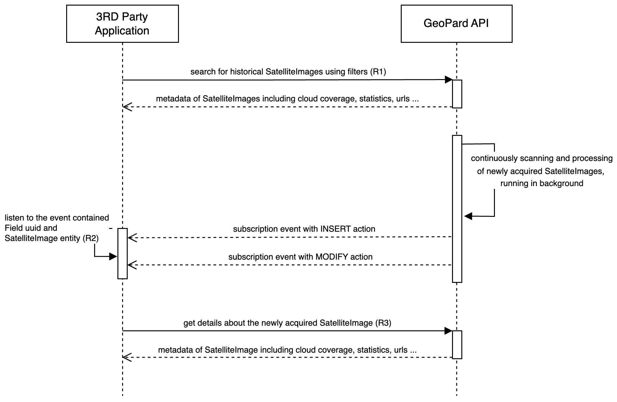
Das folgende Diagramm zeigt, wie Sie historische Satellitenbilder abrufen und neu erfasste Bilder erhalten, sobald sie in GeoPard verfügbar sind.
GeoPard unterstützt mehrere Anbieter, darunter Sentinel-2, Landsat 4/5/7/8/9 und Planet. Sie können Satellitenbilder mit allgemeinen Abfragen wie `getFarms` und `getFields`abrufen; die relevanten Daten befinden sich in der Field-Entität ([Anfrage 1 oder R1](https://docs.geopard.tech/geopard-tutorials/de/api-dokumentation/geopard-api-requests-overview/3.-query-get-satelliteimages.md)). API-Nutzer können Satellitenbilder nach Datumsbereich, Anbieter, Wolkenbedeckungsgrad und gerenderten Geokartentypen filtern.
Um über neu erfasste und verarbeitete Satellitenbilder auf dem Laufenden zu bleiben, sendet die GeoPard API Abonnementereignisse über WebSocket ([Anfrage 2 oder R2](https://docs.geopard.tech/geopard-tutorials/de/api-dokumentation/geopard-api-requests-overview/1.-subscription-get-events.md)). Wenn Sie ein `MODIFY` -Ereignis für ein Satellitenbild auf dem entsprechenden Feld erhalten, kann dieses Bild über seine UUID von der GeoPard API abgerufen werden ([Anfrage 3 oder R3](https://docs.geopard.tech/geopard-tutorials/de/api-dokumentation/geopard-api-requests-overview/4.-query-get-defined-satelliteimage.md)).
). Diese ereignisgesteuerte Architektur stellt sicher, dass API-Kunden zeitnah benachrichtigt werden und auf das neueste Satellitenbild zugreifen können, sobald es verarbeitet und verfügbar ist.
Sequenzdiagramm: Historische und neu erfasste Satellitenbilder abrufen
---
# Agent Instructions
This documentation is published with GitBook. GitBook is the documentation platform designed so that both humans and AI agents can read, navigate, and reason over technical content effectively. Learn more at gitbook.com.
## Querying This Documentation
If you need additional information that is not directly available in this page, you can query the documentation by asking a question.
Perform an HTTP GET request on the following URL with the `ask` and `goal` query parameters:
```
GET https://docs.geopard.tech/geopard-tutorials/de/api-dokumentation/diagrams-with-basic-flows/3.-get-satellite-imagery.md?ask=&goal=
```
`ask` is the immediate question: it should be specific, self-contained, and written in natural language.
`goal` is what the user is ultimately trying to achieve, the reason they need the answer. Sharing it helps GitBook give you a better, more relevant answer. A goal is most helpful when it describes the outcome the user wants rather than restating the question. For example, with `ask=how do I create an API token`, a goal like `automate deployments from our CI pipeline` lets GitBook tailor the answer to that use case.
The response will contain a direct answer to the question and relevant excerpts and sources from the documentation.
Use this mechanism when the answer is not explicitly present in the current page, you need clarification or additional context, or you want to retrieve related documentation sections.