> For the complete documentation index, see [llms.txt](https://docs.geopard.tech/geopard-tutorials/llms.txt). Markdown versions of documentation pages are available by appending `.md` to page URLs; this page is available as [Markdown](https://docs.geopard.tech/geopard-tutorials/cze/dokumentace-api/geopard-api-requests-overview/87.-mutation-save-custom-vectoranalysismap-zonesmap.md).
# 87. Mutace: Uložení vlastní vektorové analytické mapy (zónové mapy)
Níže najdete podrobnosti o tom, jak uložit vlastní mapu zón (ZonesMap) s vlastním barevným schématem.
### 1. Uložení geometrií mapy zón (ZonesMap)
{% hint style="danger" %}
VectorAnalysisMap (ZonesMap) `zonesMapGeojson` atribut musí používat projekci WGS84 (EPSG:4326) a odpovídat specifikaci GeoJSON [specifikaci](https://geojson.org/).
Očekávaný `geojson` typ je `FeatureCollection` s `MultiPolygon`.
{% endhint %}
Přehled mutace `saveVectorAnalysisMap` :
* Atribut `fieldUuid` odkazuje na existující pole.
* Atribut `name` určuje název mapy zón (ZonesMap).
* Typ atributu je hodnota výčtu představující typ operace. Může mít kteroukoli z těchto hodnot: `GENERAL` , `SPRAYING`, `SEEDING`, `FERTILIZING` nebo `IRRIGATION`. Tento atribut je nepovinný.
* Klíčovým atributem, který obsahuje všechny podrobnosti včetně dávek pro variabilní aplikaci (VRA), je `zonesMapGeojson` ve formě řetězce JSON s escapovanými znaky.
* Číslo zóny je uvedeno v `properties` >> `zone`.
* Dávky budou zahrnuty do `properties` >> `attributes`.
Atribut `properties` je objekt JSON, který se rozšiřuje o údaje `zone`, `rates`, `ratesHeaders`, `ratesPrices` a `ratesUnits` .\
Vysvětlení, jak přiřadit dávky, najdete [ZDE](https://docs.geopard.tech/geopard-tutorials/cze/dokumentace-api/geopard-api-requests-overview/85.-mutation-assign-rates-to-vectoranalysismap-zonesmap.md).
{% code overflow="wrap" lineNumbers="true" %}
```json
{
\"zone\":1,
\"attributes\":{
\"rates\":[100],
\"ratesHeaders\":[\"Product1\"],
\"ratesPrices\":[0],
\"ratesUnits\":[\"KG_HA\"]
}
}
```
{% endcode %}
Ukázková mutace bez definovaných dávek:
{% code overflow="wrap" lineNumbers="true" %}
```graphql
mutation saveVectorAnalysisMap {
saveVectorAnalysisMap(
input: {
fieldUuid:"abef3a63-a64b-4d84-aab0-43eaa8fbe0cd"
name:"Custom Zones"
zonesMapGeojson:"{\"type\":\"FeatureCollection\",\"features\":[{\"type\":\"Feature\",\"properties\":{\"zone\":1,\"attributes\":{}},\"geometry\":{\"type\":\"MultiPolygon\",\"coordinates\":[[[[10.426584494429108,52.872847225483895],[10.426789204309529,52.87282914352929],[10.42676923261385,52.87256092698456],[10.42679456306152,52.87240585041315],[10.427391783218683,52.87195386627311],[10.427338425939524,52.872087776901424],[10.427073800972806,52.87238914697767],[10.426899048635903,52.872624214183844],[10.42701887880915,52.872889416681545],[10.427403333950082,52.87288037571423],[10.427498199505067,52.872940648795804],[10.427403333950082,52.8731003720562],[10.42777780324397,52.873242012946434],[10.428022456514952,52.87323297205208],[10.428167251308338,52.8731244811766],[10.42807737867767,52.87286832108788],[10.42809735037332,52.87259407743369],[10.428501777209902,52.872404215426826],[10.428611621536277,52.87250969442229],[10.42882132434022,52.87257900905101],[10.429100928079123,52.87232585943539],[10.429155850242694,52.87216914702836],[10.429205779481066,52.87184065187668],[10.429263945397143,52.87180554285836],[10.42928833,52.87242022],[10.42922193,52.8725049],[10.42915175626986,52.87255993568499],[10.429021041297204,52.872554899627374],[10.428771395100966,52.872708596972984],[10.42838693996012,52.872847225483895],[10.428257123938948,52.87296777165494],[10.428370342208543,52.873172781233286],[10.42795711,52.87349687],[10.42718139841625,52.87321758481732],[10.427228581614003,52.87319078118864],[10.427208609918353,52.87305516741958],[10.42683913354881,52.873015990029785],[10.426664381211879,52.87293763514347],[10.426584494429108,52.872847225483895]]],[[[10.427804124872603,52.871641800637654],[10.42875584,52.87092153],[10.42897875,52.87105982],[10.42921404,52.87137376],[10.429231472601687,52.87152239994234],[10.428951140362273,52.871638731603355],[10.42879635972102,52.87193709107814],[10.428666543698995,52.872057639778546],[10.428371961188788,52.872057639778546],[10.42821218762407,52.87183161069021],[10.427967534352206,52.871708047624395],[10.427804124872603,52.871641800637654]]]]}},{\"type\":\"Feature\",\"properties\":{\"zone\":2,\"attributes\":{}},\"geometry\":{\"type\":\"MultiPolygon\",\"coordinates\":[[[[10.426899048635903,52.872624214183844],[10.427073800972806,52.87238914697767],[10.427338425939524,52.872087776901424],[10.427391783218683,52.87195386627311],[10.427804124872603,52.871641800637654],[10.427967534352206,52.871708047624395],[10.42821218762407,52.87183161069021],[10.428371961188788,52.872057639778546],[10.428666543698995,52.872057639778546],[10.42879635972102,52.87193709107814],[10.428951140362273,52.871638731603355],[10.429231472601687,52.87152239994234],[10.42926357,52.87179608],[10.429263945397143,52.87180554285836],[10.429205779481066,52.87184065187668],[10.429155850242694,52.87216914702836],[10.429100928079123,52.87232585943539],[10.42882132434022,52.87257900905101],[10.428611621536277,52.87250969442229],[10.428501777209902,52.872404215426826],[10.42809735037332,52.87259407743369],[10.42807737867767,52.87286832108788],[10.428167251308338,52.8731244811766],[10.428022456514952,52.87323297205208],[10.42777780324397,52.873242012946434],[10.427403333950082,52.8731003720562],[10.427498199505067,52.872940648795804],[10.427403333950082,52.87288037571423],[10.42701887880915,52.872889416681545],[10.426899048635903,52.872624214183844]]]]}},{\"type\":\"Feature\",\"properties\":{\"zone\":3,\"attributes\":{}},\"geometry\":{\"type\":\"MultiPolygon\",\"coordinates\":[[[[10.428257123938948,52.87296777165494],[10.42838693996012,52.872847225483895],[10.428771395100966,52.872708596972984],[10.429021041297204,52.872554899627374],[10.42915175626986,52.87255993568499],[10.428370342208543,52.873172781233286],[10.428257123938948,52.87296777165494]]],[[[10.42619246,52.87286153],[10.42679456306152,52.872405850413145],[10.42676923261385,52.87256092698456],[10.426789204309529,52.87282914352929],[10.426584494429108,52.872847225483895],[10.426664381211879,52.87293763514347],[10.42683913354881,52.873015990029785],[10.427208609918353,52.87305516741958],[10.427228581614003,52.87319078118864],[10.42718139841625,52.87321758481732],[10.42619246,52.87286153]]]]}}]}"
}
) {
uuid
}
}
```
{% endcode %}
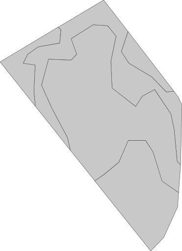
Výchozí zobrazení bez přiřazeného barevného schématu vypadá takto. Uživatelská mapa zón >> `geoMaps` >> `url` je podobná této [https://api.geopard.tech/geo/map/reflect?TRANSPARENT=true\&VIEWPARAMS=uuid:4a3929a5-c166-41d7-b547-da1511a9fa1d\&LAYERS=custom\_zone\_map\_view\&SRS=EPSG:3857\&STYLES=default\_zonesmap\&HEIGHT=64\&BBOX=1160638.4354309493,6959157.496681602,1160983.0667152018,6959632.459385279\&geopardApiKey=\](https://api.geopard.tech/geo/map/reflect?TRANSPARENT=true\&VIEWPARAMS=uuid:4a3929a5-c166-41d7-b547-da1511a9fa1d\&LAYERS=custom_zone_map_view\&SRS=EPSG:3857\&STYLES=default_zonesmap\&HEIGHT=64\&BBOX=1160638.4354309493,6959157.496681602,1160983.0667152018,6959632.459385279\&geopardApiKey=%3Cyour_geopard_api_key%3E).
### 2. Přiřaďte vlastní barevné schéma
Mutace `setGeoMaps` přehled:
* Atribut `fieldUuid` odkazuje na existující pole.
* Atribut `vectorAnalysisMapUuid` odkazuje na právě uloženou mapu zón (VectorAnalysisMap) z prvního kroku.
* Atribut `shortName` určuje styl, který se má upravit.\
Možnosti pro mapu zón jsou `zones` a `thumbnail`.
* Atribut `hexColorCodes` určuje hexadecimální barevné kódy, které se mají nastavit.
{% hint style="danger" %}
Počet barev v atributu `hexColorCodes` musí přesně odpovídat počtu existujících zón`.`
{% endhint %}
Vysvětlení, jak uložit vlastní barvy, najdete [ZDE](https://docs.geopard.tech/geopard-tutorials/cze/dokumentace-api/geopard-api-requests-overview/39.-mutation-set-custom-color-schemas-to-selected-geomaps.md) a jak průběžně použít vlastní barvy, najdete [ZDE](https://docs.geopard.tech/geopard-tutorials/cze/dokumentace-api/geo-endpoints-for-spatial-data-access/wms-get-raster-pictures-of-spatial-data-layers/6.-zonesmap-custom-color-schema.md).
Ukázková mutace:
{% code overflow="wrap" lineNumbers="true" %}
```graphql
mutation setGeoMaps{
setGeoMaps(
input: {
geoMaps:[
{
shortName:"zones"
fieldUuid:"abef3a63-a64b-4d84-aab0-43eaa8fbe0cd"
vectorAnalysisMapUuid:"9799e2eb-06d2-4a42-8f47-38655abf11e1"
hexColorCodes:[
"#ffffbf",
"#66bd63",
"#f46d43"
]
}, {
shortName:"thumbnail"
fieldUuid:"abef3a63-a64b-4d84-aab0-43eaa8fbe0cd"
vectorAnalysisMapUuid:"9799e2eb-06d2-4a42-8f47-38655abf11e1"
hexColorCodes:[
"#ffffbf",
"#66bd63",
"#f46d43"
]
}
]
}
) {
shortName
}
}
```
{% endcode %}
Výsledkem je, že vizuální zobrazení z ZonesMap >> `geoMaps` >> `url` podobné jako [https://api.geopard.tech/geo/map/reflect?TRANSPARENT=true\&VIEWPARAMS=uuid:9799e2eb-06d2-4a42-8f47-38655abf11e1\&LAYERS=custom\_zone\_map\_view\&SRS=EPSG:3857\&STYLES=default\_zonesmap\&HEIGHT=64\&BBOX=1160638.4354309493,6959157.496681602,1160983.0667152018,6959632.459385279\&env=c1:#ffffbf;c2:#66bd63;c3:#f46d43\&geopardApiKey=\](https://api.geopard.tech/geo/map/reflect?TRANSPARENT=true\&VIEWPARAMS=uuid:9799e2eb-06d2-4a42-8f47-38655abf11e1\&LAYERS=custom_zone_map_view\&SRS=EPSG:3857\&STYLES=default_zonesmap\&HEIGHT=64\&BBOX=1160638.4354309493,6959157.496681602,1160983.0667152018,6959632.459385279\&env=c1:#ffffbf;c2:#66bd63;c3:#f46d43\&geopardApiKey=%3Cyour_geopard_api_key%3E) vypadá.
---
# Agent Instructions
This documentation is published with GitBook. GitBook is the documentation platform designed so that both humans and AI agents can read, navigate, and reason over technical content effectively. Learn more at gitbook.com.
## Querying This Documentation
If you need additional information that is not directly available in this page, you can query the documentation by asking a question.
Perform an HTTP GET request on the following URL with the `ask` and `goal` query parameters:
```
GET https://docs.geopard.tech/geopard-tutorials/cze/dokumentace-api/geopard-api-requests-overview/87.-mutation-save-custom-vectoranalysismap-zonesmap.md?ask=&goal=
```
`ask` is the immediate question: it should be specific, self-contained, and written in natural language.
`goal` is what the user is ultimately trying to achieve, the reason they need the answer. Sharing it helps GitBook give you a better, more relevant answer. A goal is most helpful when it describes the outcome the user wants rather than restating the question. For example, with `ask=how do I create an API token`, a goal like `automate deployments from our CI pipeline` lets GitBook tailor the answer to that use case.
The response will contain a direct answer to the question and relevant excerpts and sources from the documentation.
Use this mechanism when the answer is not explicitly present in the current page, you need clarification or additional context, or you want to retrieve related documentation sections.