> For the complete documentation index, see [llms.txt](https://docs.geopard.tech/geopard-tutorials/llms.txt). Markdown versions of documentation pages are available by appending `.md` to page URLs; this page is available as [Markdown](https://docs.geopard.tech/geopard-tutorials/cze/dokumentace-api/diagrams-with-basic-flows/3.-get-satellite-imagery.md).
# 3. Získání satelitních snímků
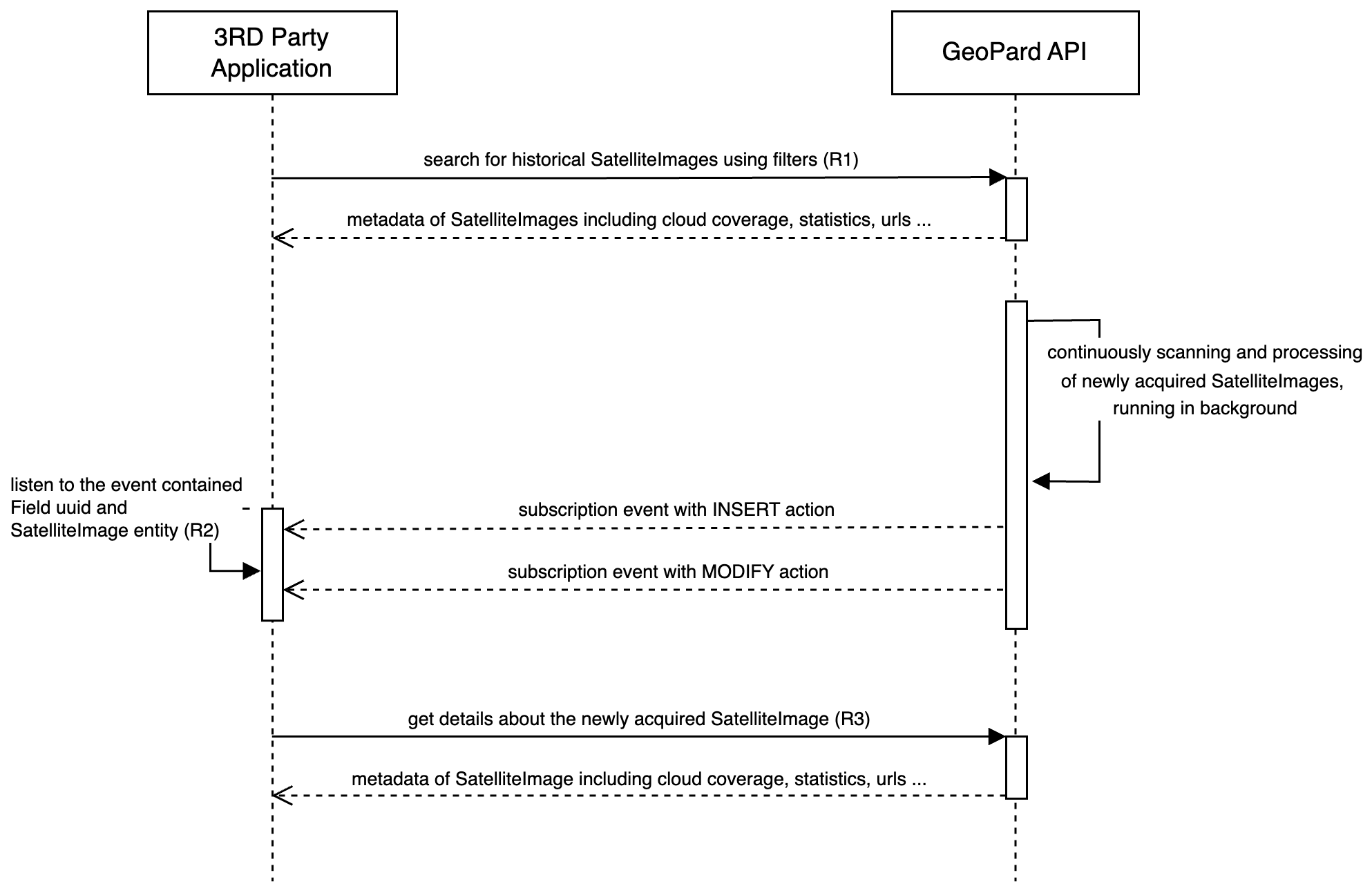
Následující diagram znázorňuje, jak získat historické satelitní snímky a dostávat informace o nově pořízených snímcích, jakmile budou v GeoPardu k dispozici.
GeoPard podporuje několik poskytovatelů, včetně Sentinel-2, Landsat 4/5/7/8/9 a Planet. Satelitní snímky můžete získávat pomocí obecných dotazů, například `getFarms` a `getFields`, přičemž příslušná data se nacházejí v entitě Field ([Požadavek 1 neboli R1](https://docs.geopard.tech/geopard-tutorials/cze/dokumentace-api/geopard-api-requests-overview/3.-query-get-satelliteimages.md)). Uživatelé API mohou satelitní snímky filtrovat podle časového období, poskytovatele, procenta pokrytí oblačností a typů vykreslených mapových podkladů.
Aby vás GeoPard informoval o nově pořízených a zpracovaných satelitních snímcích, posílá prostřednictvím WebSocketu události předplatného ([Požadavek 2 neboli R2](https://docs.geopard.tech/geopard-tutorials/cze/dokumentace-api/geopard-api-requests-overview/1.-subscription-get-events.md)). Když obdržíte událost `MODIFY` pro satelitní snímek na příslušném poli, je snímek připravený k získání z GeoPard API pomocí svého UUID ([Požadavek 3 neboli R3](https://docs.geopard.tech/geopard-tutorials/cze/dokumentace-api/geopard-api-requests-overview/4.-query-get-defined-satelliteimage.md)).
Tato architektura řízená událostmi zajišťuje, že zákazníci API dostávají oznámení bez prodlení a mohou získat nejnovější satelitní snímek, jakmile je zpracovaný a dostupný.
Sekvenční diagram: Získání historických a nově pořízených satelitních snímků
---
# Agent Instructions
This documentation is published with GitBook. GitBook is the documentation platform designed so that both humans and AI agents can read, navigate, and reason over technical content effectively. Learn more at gitbook.com.
## Querying This Documentation
If you need additional information that is not directly available in this page, you can query the documentation by asking a question.
Perform an HTTP GET request on the following URL with the `ask` and `goal` query parameters:
```
GET https://docs.geopard.tech/geopard-tutorials/cze/dokumentace-api/diagrams-with-basic-flows/3.-get-satellite-imagery.md?ask=&goal=
```
`ask` is the immediate question: it should be specific, self-contained, and written in natural language.
`goal` is what the user is ultimately trying to achieve, the reason they need the answer. Sharing it helps GitBook give you a better, more relevant answer. A goal is most helpful when it describes the outcome the user wants rather than restating the question. For example, with `ask=how do I create an API token`, a goal like `automate deployments from our CI pipeline` lets GitBook tailor the answer to that use case.
The response will contain a direct answer to the question and relevant excerpts and sources from the documentation.
Use this mechanism when the answer is not explicitly present in the current page, you need clarification or additional context, or you want to retrieve related documentation sections.