GeoPard Tutorials | Precision Ag Software
  • Introduction to GeoPard
    • GeoPard Platform: Frequently Asked Questions (FAQ)
  • 🖥️Product Tour - Web App
    • Getting Started
      • Create a new farm
      • Draw a new field
      • Upload a field boundary
      • Edit a boundary
      • Edit a field name
      • Add a label
    • 🛰️Satellite Monitoring
      • Order Planet Scope (3m daily) imagery
      • Indices for Crops and Soils
      • 📈Crop Development Index Graph
    • 📊Zones Maps and Analytics
      • Assign Variable Rates in the Zones (Ag inputs Rates Distribution Tool)
      • Creating Zones Map using Satellite Imagery
      • Creating Zones Map using Soil/Yield/As Applied Data
      • Creating Zones Map using Topography
      • Creating Zones Map using a Template
      • Draw Zones Manually, Clone from an existing layer
      • Usage of Data Classification
      • Edit Zones Map: Merge & Split
      • Multi-Year Zones
      • Multi-Layer Analytics
      • Compare layers
      • Heterogeneity factor
      • Relative variation factor
    • 📊Equation-based Analytics
      • Batch Equation analytics
      • Catalog of Predefined Agronomic Equations
      • Catalog of Custom Functions
    • ⛰️Topography
    • ⛰️3D Maps
    • Import
      • Field Boundary
      • Soil Data
      • Yield Data
      • As Applied/As Planted Data
      • Machinery Proprietary Formats
      • Import from MyJohnDeere
    • Export / Download
      • Field Boundary Export
      • Batch Export of Boundaries, Zones and Scouting Pins
      • Zones Map Export as shapefile
      • Satellite Imagery Export as geotiff or geojson
      • Export Scouting Notes as shapefile
      • Export VRA map In ISOXML Format
      • Export to MyJohnDeere
    • 🤖API
    • Operations Log - Track errors/Imports and Analytics
    • Organizations and Roles
    • Farms Sharing between Accounts & Organizations
    • Managing Crop Season information with tags(labels)
      • Case: Managing fields for several clients
      • Case: Season details including crop and year
      • Case: Field operation details
    • ⚙️User Settings
      • Subscriptions, Account limits & Plans
      • Restoring password
      • Order the package
      • Changing preferences
    • 🚜John Deere Operations Center Integration
      • 🚜John Deere Operations Center Integration
        • 1. Create Free Trial Account with you John Deere Account
        • 2. Connect to JohnDeere Operations Center
        • 3. Connect to John Deere Organizations
        • 4. Import into GeoPard from John Deere Operations Center
        • 5. Configure Automated Data Sync
        • 6. Export Rx Maps to John Deere Operations Center as Files
        • 7. Export Field Boundaries into John Deere Operations Center
          • 7a. Organization configuration of export boundary to John Deere Operations Center as File
        • 8. Export Rx Maps to John Deere Operations Center as Work Plans
        • 9. Export Soil, Topography, Satellite or Analytics as Map Layers
      • 🚜John Deere Operations Center Data Sharing
        • 1. "Staff Member" sharing
        • 2. Problem-solving of "Staff Member" sharing
        • 3. "Partner Organization" sharing
        • 4. Problem-solving of "Partner Organization" sharing
        • 5. Problem-solving of import from John Deere to GeoPard
        • 6. Problem-solving of Work Plan creation
        • 7. Sharing Fields/Boundaries Between Partner Organizations in John Deere Ops Center, DataSync config
  • 🚀Changelog & Product Releases
    • Release Notes
      • Release Web May 2025 (Rates Distribution, improved Legends)
      • Release Web March 2025 (Improved Zones, WorkPlans updates, Yield data enhancements)
      • Release Web January 2025 (Free Trial, Usage-based Pricing Plan, USDA Yield Cleaning protocol, Export of calibrated Yield data to John Deere Ops Center, Import of kml)
      • Release Web August 2024 (Data Layer Previews, Spatially localized Zones; Use zones and Equations in new Equations)
      • Release Web July 2024 (Equation Map creation, Spatially localized zones, Seeding and Application Work Plans)
      • Release Web May 2024 (Raw view for Satellite Images, export of Zone Maps as WorkPlan to the John Deere Operations Center, redesign of Batch Analytics)
      • Release Web April 2024 (Batch Equation Maps and enhanced layer transparency)
      • Release Web February 2024 (Per area pricing, units)
      • Release Web January 2024 (many UI improvements)
      • Release Web November 2023 (Clone Polygons, Subscription management)
      • Release Web October 2023 (Yield Calibration, Equation Maps as ISOXML, PDF Export and John Deere Integration)
      • Release Web September 2023 (Cleaning & Calibrating Yield Datasets, more languages support)
      • Release Mobile August 2023 (Mobile app impovements)
      • Release Web July 2023 (Operations Log page, Sum in datasets)
      • Release Web June 2023 (Improved Equations, Operations log v1)
      • Release Mobile May 2023 (Social Login)
      • Release Web May 2023 (John Deere integration improvements)
      • Release Web January 2023 (huge amount of small improvements)
      • Release Web October 2022 (Integration with AgGateway protocols, Isoxml support and more)
      • Release Web April 2022 (3D maps and Zoning Tools)
  • 👨‍🌾Agronomy
    • Precision Agronomy Use Cases & Best Practices Overview
    • Field Management Zones (Productivity Zones) Creation Process
    • Variable Rate Seeding (Planting) Maps
    • Yield Calibration & Cleaning
    • Synthetic Yield Map
    • Create Soil Sampling Zones, Points, Route, export as KML, and execute
    • Evaluate Accuracy of Seeding Application
    • Evaluate Accuracy of Fertilizer Application
    • Field Trial Analytics
    • Nitrogen Use Efficiency & Uptake
    • Comparing Yield Datasets
    • Compare Soil Scanner Data between Years
    • Flood Detection / Insurance report
    • Profit Maps (COMING)
    • VRA/Rx/Prescription Fertilizer Maps (COMING)
    • VRA/Rx/Prescription Nitrogen Maps (COMING)
    • VRA/Rx/Prescription Spraying Maps (COMING)
    • Multi-Layer Field Potential Maps (COMING)
    • VR Lime Application Based on Soil Scanner pH Data (COMING)
    • Merging Yield Datasets Belonging to the Same Field (COMING)
  • 📱Product Tour - Mobile App
    • Installation
    • Logging in
    • Viewing satellite images
    • Viewing zones maps
    • Viewing soil data
    • Viewing yield data
    • Viewing topography maps
    • Viewing as applied datasets
    • Working in the field/Scouting zones maps
    • Working offline
    • Filters
    • Options
    • Settings
  • 🤖API Docs
    • GeoPard API Overview
    • Getting Started
    • Authorization: ApiKey, Credentials or OAuth 2.0
    • Diagrams with Basic Flows
      • 1. Field Registration
      • 2. GraphQL Subscription
      • 3. Grep Satellite Imagery
      • 4. Upload Soil | AsApplied | Yield Datasets
      • 5. Execute Equations
      • 6. Generate ZonesMap
      • 7. Download Gridded Data
      • 8. Download Original Data
    • Data Schema
    • Requests Overview
      • 1. Subscription: Get Events
      • 2. Query: Get "Fields"
      • 3. Query: Get "SatelliteImages"
      • 4. Query: Get defined "SatelliteImage"
      • 5. Query: Get "RasterMaps"
      • 6. Query: Get "ZonesMaps"
      • 7. Mutation: Generate "ZonesMap"
      • 8. Mutation: Generate "RasterMap"
      • 9. Mutation: Generate "ZonesMap" asynchronously
      • 10. Mutation: Generate "RasterMap" asynchronously
      • 11. Mutation: Generate Yield based "ZonesMap" asynchronously
      • 12. Mutation: Generate Soil based "ZonesMap" asynchronously
      • 13. Mutation: Create "Farm"
      • 14. Mutation: Create a "Field" or edit the boundary of the existing field (with optional labels)
      • 15. Query: Get "TopographyMap"
      • 16. Query: Get "YieldDatasets"
      • 17. Query: Get "SoilDatasets"
      • 18. Mutation: Generate zip archive with "ZonesMap" and "Field"
      • 19. Mutation: Delete "Field"
      • 20. Mutation: Delete "Farm"
      • 21. Mutation: Delete "ZonesMap"
      • 22. Mutation: Delete "RasterAnalytisMap"
      • 23. Mutation: Delete "SoilDataset"
      • 24. Mutation: Delete "YieldDataset"
      • Notes (Pins)
        • 25. Mutation: Save "Note" attached to "Field"
        • 26. Mutation: Save "Note" attached to "ZonesMap"
        • 27. Mutation: Save "Note" attached to "SoilDataset"
        • 28. Mutation: Save multiple "Notes", Batch operation
        • 29. Mutation: Delete "Note"
        • 30. Mutation: Delete multiple "Notes"
        • 31. Query: Get all "Notes" related to "Field"
        • 32. Query: Get "Notes" related to "ZonesMap" and type
        • 33. Query: Get "Notes" related to "SoilDataset" and type
        • 34. Query: Get a selected "Note" with all "Comments"
        • 35. Mutation: Add "Comment" to the selected "Note"
        • 36. Mutation: Add multiple "Comments" to the selected "Notes"
      • 37. Query: Get "SatelliteImages" in the defined interval
      • 38. Query: Get "UserData"
      • 39. Mutation: Set custom color schemas to selected "GeoMaps"
      • 40. Query: Get "Labels" on the account level
      • 41. Mutation: Save "Labels" on the account level
      • 42. Mutation: Delete "Label" on the account level
      • 43. Query Get "Fields"
      • 44. Mutation: Set Field Labels
      • 45. Mutation: Save User Data
      • 46. Mutation: Generate multi-layer "ZonesMap" asynchronously
      • 47. Query: Get "ZonesMaps"
      • 48. Query: Get Gridded Data from "TopographyMap"
      • 49. Query: Get Gridded Data from "FieldSatelliteImage"
      • 50. Query: Get Gridded Data from "VectorAnalysisMap"
      • 51. Query: Get Gridded Data from "YieldDataset"
      • 52. Query: Get Gridded Data from "SoilDataset"
      • 53. Query: Get Gridded Data from "AsAppliedDataset"
      • 54. Query: Get Vector Data from "SoilDataset"
      • 55. Upload zip files (over 6 MB)
      • 56. Upload photos
      • 57. Query: Get "Photos" attached to the selected "Note"
      • 58. Query: Get "Photos" attached to "Comments"
      • 59. Query: Get "AsAppliedDatasets"
      • 60. Mutation: Generate As-Applied-based "ZonesMap" asynchronously
      • 61. Mutation: Delete "AsAppliedDataset"
      • 62. Mutation: Share Farms
      • 63. Mutation: Save Organization
      • 64. Mutation: Add Users to Organization
      • 65. Mutation: Delete Users from Organization
      • 66. Mutation: Save Field
      • 67. Mutation: Save Farm
      • 68. Mutation: Refresh "VectorAnalysisMap" Statistics
      • 69. Mutation: Delete "Photo"
      • 70. Mutation: Delete multiple "Photos"
      • 71. Mutation: Generate a zip archive with "Notes"
      • 72. Query: Get Gridded Data as GeoJSON or GeoTIFF
      • 73. Query: Get Gridded Data with the Selected Buffer
      • 74. Mutation: Verify "Equation"
      • 75. Mutation: Generate "EquationMap" asynchronously
      • 76. Query: Get "EquationMap"
      • 77. Mutation: Delete "EquationMap"
      • 78. Query: Find "Fields" by "externalKey"
      • 79. Query: Find "Farms" by "externalKey"
      • 80. Query: Get Original Data
      • 81. Query: Get GeoJSON of "EquationMap"
      • 82. Query: Restore Subscription Events
      • 83. Query: Collect Platform Context
      • 84. Mutation: Calibrate and Clean YieldDataset
      • 85. Mutation: Assign Rates to VectorAnalysisMap (ZonesMap)
      • 86. Query: Get "Farms"
      • 87. Mutation: Save Custom VectorAnalysisMap (ZonesMap)
      • 88. Mutation: Export ZonesMap as Zipped Shapefile
      • 89. Mutation: Export ZonesMap as Zipped ISOXML
    • Geo Endpoints
      • WMS - Get Raster Pictures of Spatial Data Layers
        • 1. LAI
        • 2. RGB
        • 3. Field: boundary
        • 4. Field: thumbnail
        • 5. ZonesMap
        • 6. ZonesMap: custom color schema
        • 7. ZonesMap: thumbnail
        • 8. RasterMap
        • 9. RasterMap: custom color schema
        • 10. RasterMap: thumbnail
        • 11. TopographyMap: elevation in absolute numbers
        • 12. YieldDatasetsMap
        • 13. SoilDatasetsMap
        • 14. SoilDatasetsMap: custom color schema
        • 15. AsAppliedDatasetsMap
        • 16. Satellite Image: cropped by Field boundary
        • 17. Satellite Image: cropped by Field boundary and custom color schema
        • 18. YieldDatasetsMap: custom color schema
        • 19. Satellite Image: 10 colors visualization
      • WFS - Get Spatial Data Layers in Vector format (shp, geojson)
        • 1. Get the Field Boundary as Geojson
        • 2. Get the Zones map as Geojson
        • 3. Get Zones Attributes as JSON
        • 4. Get Soil data as Geojson
        • 5. Get Yield data as Geojson
    • Uploading Files
    • API FAQ
  • 🛣️Platform Roadmap
    • Roadmap
  • GIS quick Hints
    • QGIS: Change String to Number values in the shapefile
    • QGIS: Yield Data Manipulations
    • QGIS: Split Boundaries Into Subfields
    • QGIS: Merge Vector Layers
    • QGIS: Merge Selected Features from Vector Files
    • QGIS: Calculate NDVI for the Drone Geotiff File
    • QGIS: Split Multi-field Shapefiles
    • QGIS: Convert CSV to SHP
    • QGIS: Reproject Shapefile
  • Policies
    • Your Data Stays Yours, Securely Managed By GeoPard
    • Terms & Conditions
    • Privacy Policy
Powered by GitBook

Start Working with GeoPard

  • Go to GeoPard Website
  • Demo Request
  • LinkedIn

This Portal Sections

  • Introduction
  • Product Tour - Web App (incl. video)
  • Product Tour - Mobile App (incl. video)
  • Precision Agronomy Use Cases

Powered by GeoPard Agriculture - Automated precisionAg platform

On this page
  • More Input Options for Equation Map Creation
  • New Spatially Localized Zones Classification
  • Seeding and Application Work Plans for Export
  • Satellite Imagery for Batch Creation of Equation Maps
  • Configure John Deere Subscription with Operation Types
  • Visibility of Unavailable John Deere Actions
  • Select Zones for Operations from the Statistics Block
  • File Type Label in Upload Popup
  • Optimized Tile Sizes for Faster Rendering
  • Dropdown Menus Icons for Better Navigation
  • Additional Enhancements and Fixes

Was this helpful?

  1. Changelog & Product Releases
  2. Release Notes

Release Web July 2024 (Equation Map creation, Spatially localized zones, Seeding and Application Work Plans)

Enhanced Equation Map creation, Spatially localized zones, Seeding and Application Work Plans, satellite imagery for batch analysis, improved John Deere integration and UI navigation.

PreviousRelease Web August 2024 (Data Layer Previews, Spatially localized Zones; Use zones and Equations in new Equations)NextRelease Web May 2024 (Raw view for Satellite Images, export of Zone Maps as WorkPlan to the John Deere Operations Center, redesign of Batch Analytics)

Last updated 8 months ago

Was this helpful?

More Input Options for Equation Map Creation

The GeoPard team has introduced a new functionality that lets you and as input layers when creating a new Equation Map. You can now select these maps directly from the UI, making incorporating them into your calculations easier. The application will also provide detailed information about the Equation Maps and Zones Maps used, ensuring you have a clear view of all the variables involved, just like with other data layers.

New Spatially Localized Zones Classification

The GeoPard team has introduced a new classification type designed to create more manageable zones for agronomic tasks like soil sampling, fertilizing, and seeding. This new classification method clusters data geospatially, resulting in smaller, localized zones that are practical for fieldwork. By avoiding overly large zones, this update helps ensure that your zones are efficient and easy to manage, addressing feedback from growers who found previous classifications too broad.

Seeding and Application Work Plans for Export

Satellite Imagery for Batch Creation of Equation Maps

You can now use Satellite Imagery for batch Equation Map creation. Satellite images are available for manual selection, allowing you to choose multiple images at once for your analysis. Additionally, recommended images can be selected, making it easier to optimize your workflows for both batch and single equation-based processes.

Configure John Deere Subscription with Operation Types

We’ve introduced new controls that allow you to manage and view the operation types collected through your John Deere subscription. On the integration page, you can now configure which dataset types — such as Application, Harvest, and Seeding — will be automatically collected from your John Deere Operations Center account. Once selected, these operation types will be visible in the Field Operations section, making managing your subscriptions alongside your list of organizations easier.

Visibility of Unavailable John Deere Actions

To enhance transparency, all John Deere actions are now visible in the UI, even when they’re unavailable. Actions such as "Export to John Deere as Map Layers" will appear disabled if the required conditions aren't met. Tooltips have been added to guide you on how to unlock these actions, providing clear instructions on what steps are needed to enable the features.

Select Zones for Operations from the Statistics Block

We’ve made it easier to select entire zones during the Draw Manually flow by making zones in the Statistics table clickable. Now, when using tools like "Merge Polygons" or "Change Polygon Color," you can directly select multi-polygons from the Statistics table. Once selected, the corresponding zones will be highlighted on both the map and the table, simplifying zone management and editing.

File Type Label in Upload Popup

We make it easier to identify the type of uploaded files by adding a file type label in the upload popup. This label, displayed next to the file name, allows you to quickly verify the data type of your uploads.

Optimized Tile Sizes for Faster Rendering

We’ve made it easier to experience faster tile rendering by applying various tile sizes based on asset type. This optimization improves loading times and ensures smoother performance when working with different assets.

Dropdown Menus Icons for Better Navigation

We’ve made it easier to distinguish menu items by adding icons to dropdown menus across the app. This update enhances visual clarity, helping you quickly identify and select the right options.

Additional Enhancements and Fixes

  • Selection Limit Highlighting: The asset tree now highlights when you reach the selection limit, making it easier to manage your choices.

  • Automatic Organization Expansion: The first organization in your list will now automatically expand for quicker access.

  • Improved Variable Fetching: Newly generated equation maps will now properly fetch the required variables, ensuring smoother operation.

  • Refined Satellite Image Selection: Satellite image selection for batch analysis has been improved for better usability.

  • Accurate Variable Updates: Variables will now update correctly after changes in the equation-based flow, preventing any inconsistencies.

  • Attributes Search Fix: Fixed an issue where search results were being duplicated, ensuring accurate search results.

  • Custom Equation Saving: Resolved an issue preventing custom equation saving for some users.

  • Event Aggregation Improvement: Zones Maps events are now aggregated more effectively for a better user experience.

Behind-the-scenes updates include improved error logging, the removal of unused code, and enhanced automated test coverage for various GeoPard capabilities.

We’ve expanded your ability to export Zones Maps by introducing Seeding and Application Work Plan types that sync with John Deere. You can now directly from the Equation/Zones Map menu or the Field page top panel, with preselected options based on your map's purpose. This update supports efficient field planning, allowing up to four different application types in a single plan. Units will automatically adjust based on your preferred area unit, ensuring accuracy in your operations.

🚀
create Work Plans
Zones Maps
use your existing Equation Maps
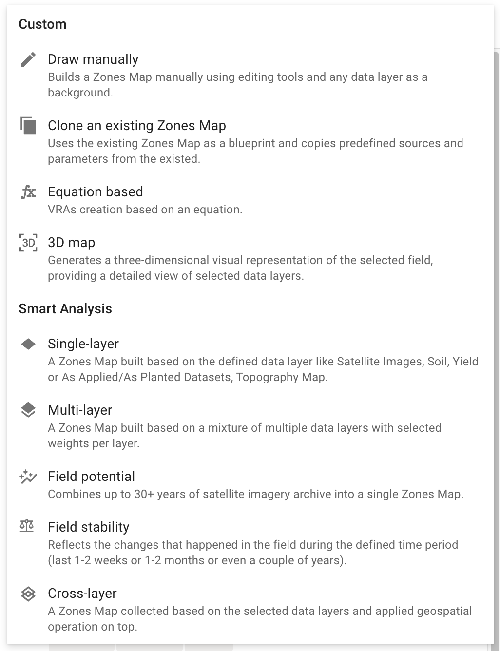
Spatially localized zones allow keeping balance between detailed field variability management zones & grid sampling.
Visibility of Unavailable John Deere Actions
Select Zones for Operations from the Statistics Block
File Type Label in Upload Popup
Optimized Tile Sizes for Faster Rendering
Spatially Localized
Work Plan Capabiltites Overview