> For the complete documentation index, see [llms.txt](https://docs.geopard.tech/geopard-tutorials/llms.txt). Markdown versions of documentation pages are available by appending `.md` to page URLs; this page is available as [Markdown](https://docs.geopard.tech/geopard-tutorials/bg/produktova-obikolka-ueb-prilozhenie/zones-maps-and-analytics.md).

# Карти и анализи на зони

Създавайте зони за управление от изображения, добив, почва, топография и уравнения за по-добри решения за променлива норма.

Потребителите могат да започнат създаването на карта на зони по два начина. Първият е чрез бутона **Създаване на карта на зони** , който им позволява да изберат как да създадат картата на зони. Вторият начин е чрез **Клониране** на съществуваща карта на зони, за да изпробват параметри и промени, без да променят избора на работен процес за създаване на картата.

{% hint style="info" %}
Вижте интерактивната страница за управление на зони и VRA карти на geopard.tech: [Зони за управление и VRA карти](https://geopard.tech/management-zones-vra-maps/)
{% endhint %}

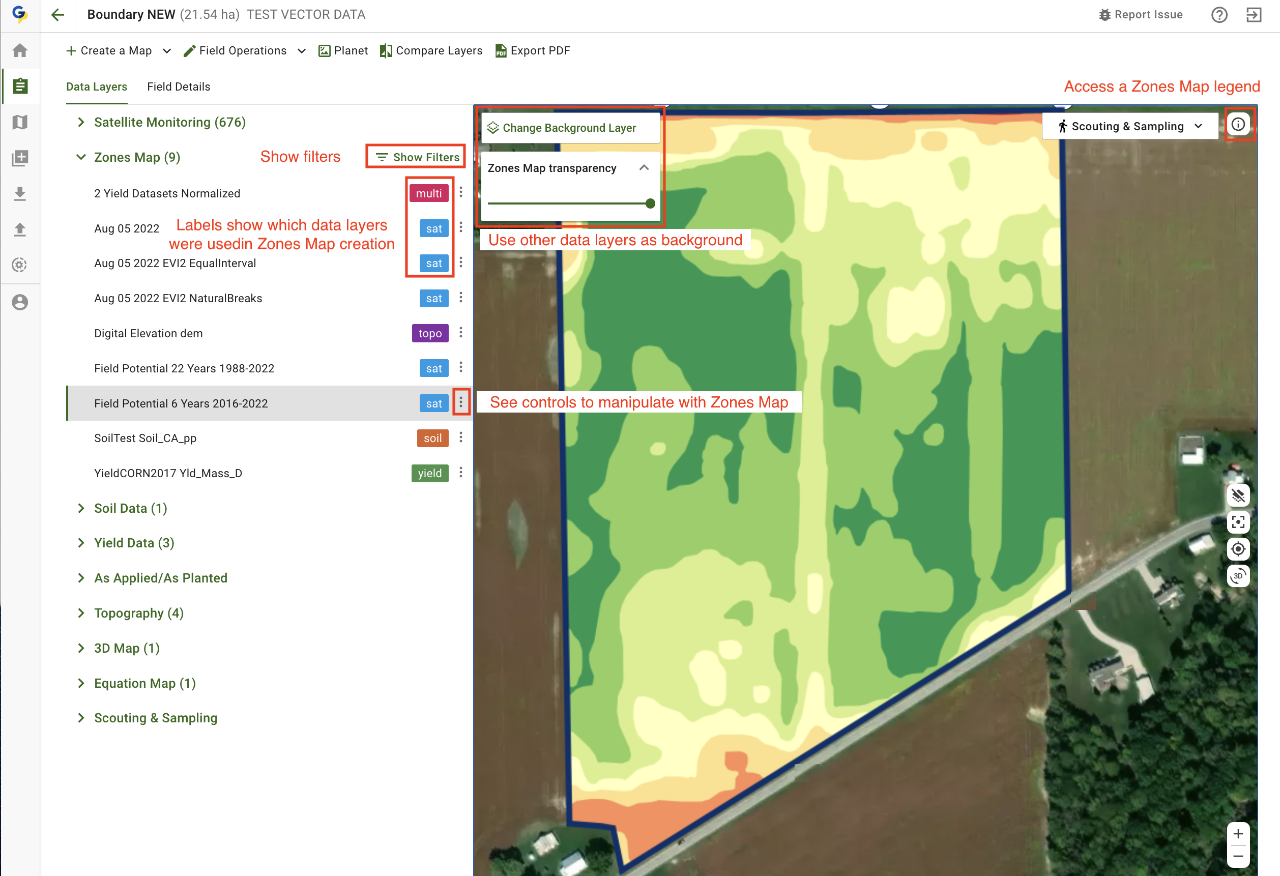
## Преглед на картата на зони

На следващите екрани ще намерите кратък преглед на наличните контроли, който ще ви помогне да разберете каква информация се намира във всяка част на екрана.

<figure><img src="https://190376946-files.gitbook.io/~/files/v0/b/gitbook-x-prod.appspot.com/o/spaces%2FYICBELdyAXXebKAzfLOR%2Fuploads%2Fxq40oN6Fp3OTLVB3vxAn%2Fimage.png?alt=media&amp;token=05cbc074-02d2-4219-bdc4-0554998436d9" alt=""><figcaption><p>Контроли на картите на зони</p></figcaption></figure>

<figure><img src="https://190376946-files.gitbook.io/~/files/v0/b/gitbook-x-prod.appspot.com/o/spaces%2FYICBELdyAXXebKAzfLOR%2Fuploads%2F6qMbc4RgZYE5WC4KKuAJ%2Fimage.png?alt=media&amp;token=e2bda194-60c7-4e34-baa2-434bc94b3ee9" alt=""><figcaption><p>Контроли на картите на зони</p></figcaption></figure>

## Използване на бутона за създаване на карта на зони

За да създадете карта на зони за свое поле, отворете го от списъка с полета и щракнете върху бутона **Създаване на карта на зони** :

<figure><img src="https://lh5.googleusercontent.com/7IapbLUHoeZR3k-q_yNsfktTcTTbd7sJbLdflCuRCauAHm88Ckro45eeRObbCDU2SvcOj3yzBpRRUHdqYaME8cYYAodwpLQVohl3HloDgzdG4VhIEdD9f6M9gdV4uh2Ogj9ioGG1" alt="This image has an empty alt attribute; its file name is 24-1.png" width="563"><figcaption><p>Стартиране на работния процес за създаване на карта на зони</p></figcaption></figure>

Ще преминете към инструмента за създаване на зони, където трябва да изберете какъв тип карта на зони искате да създадете.

<figure><img src="https://lh6.googleusercontent.com/M5yZVRKrPxTeEzqGoNxeTo_pIY8lZhPmRK_CfkaarMSTtUzaTmih2fE_JCN8Xazjj3KeSTeJ7LatqzbInUtWDydLFnyL3Lv4dF65TGC0AS-ivaAleEszHnz8-CjotlhMZAJl4fz9" alt="This image has an empty alt attribute; its file name is image-1.png" width="563"><figcaption><p>Налични типове карти на зони</p></figcaption></figure>

Повече информация за използването на различните типове ще намерите в следващите раздели:

1. [Създаване на карта на зони със сателитни изображения](https://docs.geopard.tech/geopard-tutorials/bg/produktova-obikolka-ueb-prilozhenie/zones-maps-and-analytics/create-a-zones-map-using-satellite-imagery.md)
2. [Създаване на карта на зони с данни за почвата, добива или извършените операции](https://docs.geopard.tech/geopard-tutorials/bg/produktova-obikolka-ueb-prilozhenie/zones-maps-and-analytics/create-a-zones-map-using-soil-yield-or-as-applied-data.md)
3. [Създаване на карта на зони с топографски данни](https://docs.geopard.tech/geopard-tutorials/bg/produktova-obikolka-ueb-prilozhenie/zones-maps-and-analytics/create-a-zones-map-using-topography.md)
4. [Създаване на карта на зони по шаблон](https://docs.geopard.tech/geopard-tutorials/bg/produktova-obikolka-ueb-prilozhenie/zones-maps-and-analytics/create-a-zones-map-using-a-template.md)
5. [Използване на класификация на данните](https://docs.geopard.tech/geopard-tutorials/bg/produktova-obikolka-ueb-prilozhenie/zones-maps-and-analytics/using-data-classification.md)
6. [Как да зададете VRA](https://docs.geopard.tech/geopard-tutorials/bg/produktova-obikolka-ueb-prilozhenie/zones-maps-and-analytics/assign-variable-rates-in-zones-ag-input-rates-distribution-tool.md)
7. [Редактиране на карта на зони: обединяване и разделяне](https://docs.geopard.tech/geopard-tutorials/bg/produktova-obikolka-ueb-prilozhenie/zones-maps-and-analytics/edit-zones-map-merge-and-split.md)
8. [Зони за няколко години](https://docs.geopard.tech/geopard-tutorials/bg/produktova-obikolka-ueb-prilozhenie/zones-maps-and-analytics/multi-year-zones.md)
9. [Многослойни анализи](https://docs.geopard.tech/geopard-tutorials/bg/produktova-obikolka-ueb-prilozhenie/zones-maps-and-analytics/multi-layer-analytics.md)

## Клониране на съществуваща карта на зони

За да клонирате съществуваща карта на зони, щракнете върху бутона <img src="https://190376946-files.gitbook.io/~/files/v0/b/gitbook-x-prod.appspot.com/o/spaces%2FYICBELdyAXXebKAzfLOR%2Fuploads%2F3vG8QyQkqzewbqEGatt6%2Fimage.png?alt=media&amp;token=740d067b-4388-47b8-b28f-b308efc70c00" alt="" data-size="line"> и изберете опцията **Клониране** . Ще преминете към работния процес за създаване на карта на зони, зареден с използваните преди това настройки, като слоеве с данни, брой зони и други параметри.

<figure><img src="https://190376946-files.gitbook.io/~/files/v0/b/gitbook-x-prod.appspot.com/o/spaces%2FYICBELdyAXXebKAzfLOR%2Fuploads%2FLZZvkkL1VF7uAFBMBbuR%2Fimage.png?alt=media&amp;token=cf13456d-7817-4ce8-b861-c7d08286e983" alt="" width="563"><figcaption><p>Стартиране на клонирането на съществуваща карта на зони</p></figcaption></figure>


---

# Agent Instructions
This documentation is published with GitBook. GitBook is the documentation platform designed so that both humans and AI agents can read, navigate, and reason over technical content effectively. Learn more at gitbook.com.

## Querying This Documentation
If you need additional information that is not directly available in this page, you can query the documentation by asking a question.

Perform an HTTP GET request on the following URL with the `ask` and `goal` query parameters:

```
GET https://docs.geopard.tech/geopard-tutorials/bg/produktova-obikolka-ueb-prilozhenie/zones-maps-and-analytics.md?ask=<question>&goal=<user_goal>
```

`ask` is the immediate question: it should be specific, self-contained, and written in natural language.
`goal` is what the user is ultimately trying to achieve, the reason they need the answer. Sharing it helps GitBook give you a better, more relevant answer. A goal is most helpful when it describes the outcome the user wants rather than restating the question. For example, with `ask=how do I create an API token`, a goal like `automate deployments from our CI pipeline` lets GitBook tailor the answer to that use case.

The response will contain a direct answer to the question and relevant excerpts and sources from the documentation.

Use this mechanism when the answer is not explicitly present in the current page, you need clarification or additional context, or you want to retrieve related documentation sections.
