> For the complete documentation index, see [llms.txt](https://docs.geopard.tech/geopard-tutorials/llms.txt). Markdown versions of documentation pages are available by appending `.md` to page URLs; this page is available as [Markdown](https://docs.geopard.tech/geopard-tutorials/bg/produktova-obikolka-ueb-prilozhenie/karti-i-analizi-na-zoni/faktor-na-otnositelna-variaciya.md).
# Фактор на относителна вариация
Количествено определяйте пространствената вариация спрямо средната стойност, за да сравнявате вариабилността между полета и набори от данни.
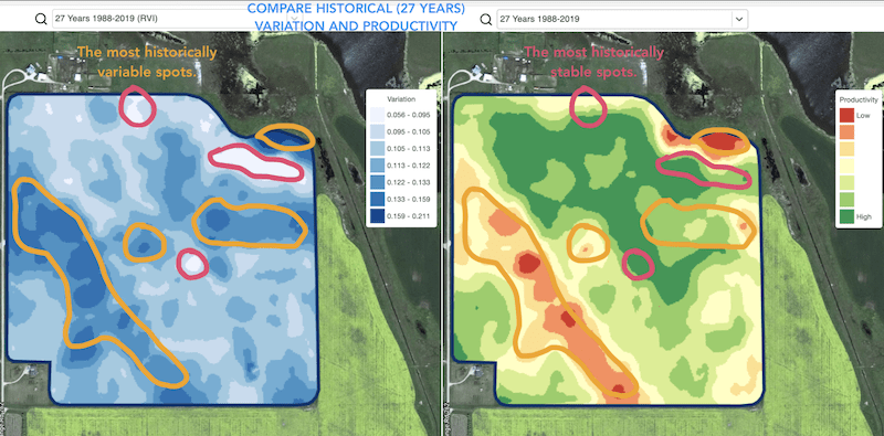
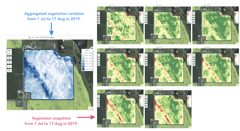
Откриването на промените, настъпили в полето през последните една-две седмици, една-две месеца или дори за няколко години, помага да се получат по-добри насоки за развитието на културите.
Относителният фактор на вариация или Индексът на относителна вариация могат да се използват за:
* локализиране на места с подобно представяне в рамките на 5-10-20 години и поставяне на опитите в зони с подобни условия, за да се намали вероятността от грешка
* проследяване на промените през сезона и оценка на представянето на културите по време на вегетацията
* разпознаване на увредените площи след метеорологично бедствие, болест или нападение от неприятели и изчисляване на увредените площи
* откриване на разликата между последните два образа и контрол на представянето на културите.
Индексът на относителна вариация (RVI) на GeoPard покрива всички тези случаи и много други. RVI ще даде повече насоки за развитието на културите, когато се използва заедно с вегетационни и исторически управленски зони.
Просто изберете вашето поле и сателитни изображения, за да проследите промените в тях и да получите насоки за всяко място във вашето поле.
---
# Agent Instructions
This documentation is published with GitBook. GitBook is the documentation platform designed so that both humans and AI agents can read, navigate, and reason over technical content effectively. Learn more at gitbook.com.
## Querying This Documentation
If you need additional information that is not directly available in this page, you can query the documentation by asking a question.
Perform an HTTP GET request on the following URL with the `ask` and `goal` query parameters:
```
GET https://docs.geopard.tech/geopard-tutorials/bg/produktova-obikolka-ueb-prilozhenie/karti-i-analizi-na-zoni/faktor-na-otnositelna-variaciya.md?ask=&goal=
```
`ask` is the immediate question: it should be specific, self-contained, and written in natural language.
`goal` is what the user is ultimately trying to achieve, the reason they need the answer. Sharing it helps GitBook give you a better, more relevant answer. A goal is most helpful when it describes the outcome the user wants rather than restating the question. For example, with `ask=how do I create an API token`, a goal like `automate deployments from our CI pipeline` lets GitBook tailor the answer to that use case.
The response will contain a direct answer to the question and relevant excerpts and sources from the documentation.
Use this mechanism when the answer is not explicitly present in the current page, you need clarification or additional context, or you want to retrieve related documentation sections.